Navajo River
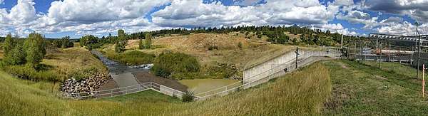
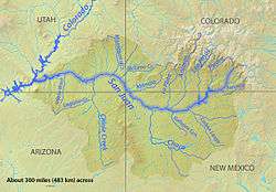
Navajo River (Jicarilla Apache: Lóolahó) is a 54-mile-long (87 km)[3] tributary of the San Juan River. It flows from a source in the South San Juan Wilderness of Conejos County, Colorado southwest past Chromo, Colorado. The river dips into New Mexico, passing just north of Dulce before heading northwest to a confluence with the San Juan in Archuleta County, Colorado.[4] A large portion of its water is diverted across the Continental Divide to the Rio Grande basin as part of the San Juan–Chama Project.[5]
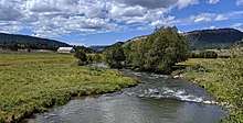
Navajo River just above US Highway 84 at Chromo
| Navajo River[1] Lóolahó (in Jicarilla Apache)[2] | |
|---|---|
 | |
| Physical characteristics | |
| Source | |
| ⁃ coordinates | 37°15′12″N 106°38′43″W |
| Mouth | |
⁃ location | Confluence with San Juan |
⁃ coordinates | 37°01′26″N 107°09′31″W |
⁃ elevation | 6,319 ft (1,926 m) |
| Basin features | |
| Progression | San Juan—Colorado |
See also
References
- "Navajo River". Geographic Names Information System. United States Geological Survey. Retrieved 2011-02-02.
- Phone, Wilhelmina et al. Abáachi Mizaa Iłkeeʼ Siijai. University of New Mexico Press. Albuquerque, NM: 2007.
- "The National Map". U.S. Geological Survey. Retrieved Feb 11, 2011.
- "October 31, 2012--Water 2012 visits Southwest Basin (Alamosa News) | The Water Information Program". www.waterinfo.org. Retrieved 2017-06-16.
- "San Juan Chama Project". www.abcwua.org. Retrieved 2017-06-16.
This article is issued from Wikipedia. The text is licensed under Creative Commons - Attribution - Sharealike. Additional terms may apply for the media files.