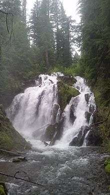
National Creek Falls
National Creek Falls is a waterfall from National Creek, that plunges into a grotto surrounded by a meadow of mosses on the west skirt of the Crater Lake National Park, north of Union Creek, Oregon.[1]
| National Creek Falls | |
|---|---|
 National Creek Falls | |
| Location | Douglas County, Oregon |
| Coordinates | 43.03141°N 122.34466°W |
| Type | Cascade, Plunge |
| Elevation | 3,863 ft (1,177 m) |
| Total height | 40 ft (12 m) |
| Number of drops | 1 |
| Average width | 30 ft (9 m) |
| Average flow rate | 150 cu ft/s (4.2 m3/s) |
History
National Creek Falls lays adjacent to Diamond Lake Road off US Route 62. The road was once a wagon route used for travel from the Rogue Valley to the newly discovered gold mines in the John Day Valley. The drainage of National Creek was then a popular layover site for miners and stock-men travelers that passed at Lake West towards the John Day Valley. After a fire devastated the area in the early 1860s the route was reopened in 1910 by the Forest Service, now known as Diamond Lake Road.[2]
Trail
National Creek Falls is located on pumice flanks of Mount Mazama with basalt outcropping that diverges the creek into a wide waterfall. The National Creek Falls trail starts off Crater Lake Highway and descends through a shaded, mixed conifer forest, ending at the base of National Creek Falls, totaling 0.75 mi (1.21 km).[2]
See also
References
- "National Creek Falls - Douglas County, Oregon". Northwest Waterfall Survey. Retrieved 10 June 2017.
- "National Creek Falls Trail #1053". United States Department of Agriculture - Forest Service. Retrieved 10 June 2017.