Napo River
The Napo River (Spanish: Río Napo) is a tributary to the Amazon River that rises in Ecuador on the flanks of the east Andean volcanoes of Antisana, Sinchulawa and Cotopaxi.
| Napo river | |
|---|---|
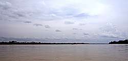 The Napo River to the east of Coca | |
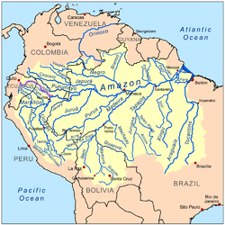 Map of the Amazon Basin with the Napo River highlighted | |
| Location | |
| Countries | |
| Physical characteristics | |
| Source | Cotopaxi in the Andes |
| • location | Ecuador |
| • coordinates | 0°40′S 78°25′W |
| Mouth | Amazon River |
• location | 70 km (43 mi) downstream from Iquitos, Loreto Region, Peru |
• coordinates | 3°27′28″S 72°43′3″W |
| Length | 1,130 km (700 mi)[1] |
| Basin size | 100,518 km2 (38,810 sq mi) |
| Discharge | |
| • average | 6,300 m3/s (220,000 cu ft/s) |
| Basin features | |
| Tributaries | |
| • left | Aguarico River, Coca River, Payamino River, Misahualli River |
| • right | Yasuní River, Tiputini River |
The total length is 1,075 km (668 mi). The river drains an area of 100,518 km2 (38,810 sq mi). The mean annual discharge is 6,300 m3 (220,000 cu ft) per second.[2]
Before it reaches the plains it receives a great number of small streams from impenetrable, saturated and much broken mountainous districts, where the dense and varied vegetation seems to fight for every piece of ground. This river is one of Ecuador's Physical Features. From the north it is joined by the Coca River, having its sources in the gorges of Cayambe volcano on the equator, and also a powerful river, the Aguarico having its headwaters between Cayambe and the Colombia frontier.
From the west, it receives a secondary tributary, the Curaray, from the Andean slopes, between Cotopaxi and the Tungurahua volcano. From its Coca branch to the mouth of the Curaray the Napo is full of snags and shelving sandbanks and throws out numerous canoes among jungle-tangled islands, which in the wet season are flooded, giving the river an immense width. From the Coca to the Amazon it runs through a forested plain where not a hill is visible from the river - its uniformly level banks being only interrupted by swamps and lagoons.
From the Amazon the Napo is navigable for river craft up to its Curaray branch, a distance of about 216 mi (348 km), and perhaps a bit further; thence, by painful canoe navigation, its upper waters may be ascended as far as Santa Rosa, the usual point of embarkation for any venturesome traveller who descends from the Quito tableland. The Coca river may be penetrated as far up as its middle course, where it is jammed between two mountain walls, in a deep canyon, along which it dashes over high falls and numerous reefs. This is the stream made famous by the expedition of Gonzalo Pizarro.
See also
References
- Ziesler, R.; Ardizzone, G.D. (1979). "Amazon River System". The Inland waters of Latin America. Food and Agriculture Organization of the United Nations. ISBN 92-5-000780-9. Archived from the original on 8 November 2014.
- http://hal.ird.fr/docs/00/55/53/50/PDF/160908_Napo_River_for_HP.pdf