Nap-of-the-earth
Nap-of-the-earth (abbreviated NOE) is a type of very low-altitude flight course used by military aircraft to avoid enemy detection and attack in a high-threat environment.[1]
During NOE flight, geographical features are used as cover, exploiting valleys and folds in the terrain by flying in, rather than over, them. This keeps below enemy air defence radar coverage, avoiding being silhouetted against the sky. Other, mostly older terms include "ground-hugging", "terrain masking", "flying under the radar" and "hedgehopping".
Purpose
NOE is used to minimize detection by hostile aircraft, AWACS surveillance and control systems, ground-based radar, or attack targets.[1]
A high-flying aircraft can be detected by defense systems at long range, giving an air defense system time to react, alerting SAM and AAA missile systems and fighter aircraft. Using NOE flight, the approach may be undetected; the aircraft "pops up" to attack the target and then turns to escape before the enemy can respond. Doppler radar has the potential to detect NOE flight, but the incoming aircraft has to be within radar range in the first place, and low flight minimizes this possibility by using hills and mountains to break the line of sight (terrain masking), defeating terrestrial air defense radar and in rough enough terrain also airborne early warning.[2]
Sensors for NOE
Most NOE flying is done during the day using visual reference by pilots who are experienced in low flying. Data from a radar altimeter or terrain-following radar system is also used, the latter enabling low flying in adverse weather where it would not be possible by visual reference and manual pilot control. At night, a night-vision device may be used.
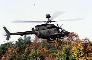
Helicopter NOE flying
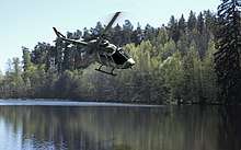
The lowest NOE flying is by helicopters because they have lower speeds and more maneuverability than fixed-wing aircraft, particularly fast-jets. Helicopters can fly at treetop levels or even below the height of surrounding trees where there are clear areas (such as in river gullies),[1] flying under wires (such as electricity cables) rather than over them. Attack helicopters can hide behind trees or buildings, "popping up" just enough to use their (rotor mast-mounted) radar or other sensors and then minimally exposing themselves to launch weapons.[3] The required altitude depends on the type of terrain, such as low vegetation or low buildings, tree canopy layer of less than 45 m (148 ft), presence of tall buildings or concrete pylons with heights of up to 25 m (82 ft) international standard, or emergent tree layer canopy and lattice steel electricity pylons to 100 m (330 ft) being present. Over populated areas with tall radio transmission towers, an altitude of 150 m (490 ft) AGL applies.
In May 2011, four U.S. military helicopters evaded the Pakistani air defense system during the Osama bin Laden mission. Officials in Pakistan attributed the failure to detect the aircraft to their use of nap-of-the-earth flying techniques.[4]
Height Above Ground Level
Height Above Ground Level (AGL) in NOE and low flying generally vary with the aircraft speed, aircraft maneuverability and the ruggedness of the terrain. Helicopters are capable of flying with no more than a few feet of clearance below the helicopter's skids or wheels. Fast jets are more constrained and at a typical low-flying speed of 450 knots (800 km/h), 200 feet (60 m) is not unusual and 50 feet (15 m) is possible in relatively flat terrain. Power wires are a danger to all aircraft flying at low level and "wire strikes" are common, such as the Cavalese cable car disaster.[5] Special maps are produced that plot the routes of these wires but these are difficult to keep up-to-date, especially for foreign/enemy countries. Pilots are trained to scan for the pylons or power-poles that support these wires, because they can be seen at a distance where the wires themselves cannot.
See also
References
- Helicopters at War - Blitz Editions, Bookmart Limited, 1996, ISBN 1-85605-345-8
- Nelson, Dean; Pearlman, Jonathan (17 March 2014). "Missing Malaysia plane flew at 5,000ft and used 'terrain masking' to avoid radar detection". The Telegraph. Retrieved 7 March 2017.
- Cacutt, Len (1989). Combat. Aerospace Publishing Ltd. p. 185. ISBN 1-55521-240-9.
- http://www.thehindu.com/opinion/lead/pakistan-military-caught-in-the-crossfire/article1991627.ecePakistan military caught in the crossfire - Baqir Sajjad Syed Dawn, The Hindu, May 5, 2011
- Tagliabue, John (4 February 1998). "20 Die in Italy As U.S. Jet Cuts A Ski Lift Cable". The New York Times. Retrieved 7 March 2017.