Myoe Haung
Myoe Haung or Myohaung[2](S'gaw Karen: ဍုံလီ; Burmese: မြို့ဟောင်း [mjo̰ ha̰ʊN]) is a village in Kyain Seikgyi Township, Kawkareik District, in the Kayin State of Burma (Myanmar).[3] It is on the Sadaw Marsh (Sadaw Chaung), eastern part of the foothills of the Tenasserim Range.[4]
Myoe Haung မြို့ဟောင်း Doh -Li | |
|---|---|
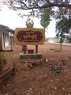 Myohaung welcome signboard | |
 Myoe Haung Location in Myanmar | |
| Coordinates: 16°06′59″N 97°53′50″E | |
| Country | |
| State | |
| District | Kawkareik District |
| Township | Kyain Seikgyi Township |
| Population | |
| • Religions | Buddhism |
| Time zone | UTC+6.30 (MST) |
| Area code(s) | 58[1] |
References
- "Myanmar Area Codes". Archived from the original on 2009-12-01. Retrieved 2009-04-10.
- Myohaung (Approved) at GEOnet Names Server, United States National Geospatial-Intelligence Agency
- "Township Map of Kyainseikgyi" (PDF). Myanmar Information Management Unit (MIMU). 3 May 2016. Retrieved 22 November 2017.
- "Burma 1:250,000 topographic map, Series U542, Moulmein, NE 47-14" U.S. Army Map Service, December 1959
External links

- "Myohaung Map — Satellite Images of Myohaung" Maplandia World Gazetteer
Capital: Hpa-an | ||
| Hpa-an District | 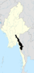 | |
| Hpapun District | ||
| Kawkareik District | ||
| Myawaddy District | ||
| Cities and towns | ||
This article is issued from Wikipedia. The text is licensed under Creative Commons - Attribution - Sharealike. Additional terms may apply for the media files.