Mukibanda Yayoi remains
Mukibanda Yayoi Settlement Site (妻木晩田遺跡, Mukibanda-iseki) is the largest Yayoi period remains in Japan.[1] The Mukibanda site is located in the low foothills of Mount Daisen[2] in the cities of Daisen and Yonago, Tottori Prefecture. The Mukibanda site was designated a Monument of Japan in 1999.[3]
妻木晩田遺跡 | |
 Mukibanda Yayoi Settlement Site, Mukiyami area | |
 Shown within Japan | |
| Location | Yonago and Daisen, Tottori Prefecture, Japan |
|---|---|
| Coordinates | 35°27′36″N 133°26′51″E |
| History | |
| Periods | Yayoi period |
| Cultures | Yayoi culture |
General description
The Mukibanda Yayoi Settlement Site ranges between 90 metres (300 ft) and 120 metres (390 ft) above sea level, and covers 170 hectares (420 acres). The settlement was naturally protected by the foothills of Mount Daisen, yet had close access to Miho Bay on the Japan Sea, which is clearly visible from the site.[2]
Discovery
Construction of a golf course was planned on the site in the early 1990s, but after an examination of the area by the Boards of Education of Daisen and Yodoe, now Yonago City, between 1995 and 1998, a national-level conservation movement sought to protect the area from development.[2] The site was designated a "Historic Site, Place of Scenic Beauty, and Natural Monument (史跡名勝天然記念物, Shiseki meishō tennen kinenbutsu)" by the Agency for Cultural Affairs, a special body of the Japanese Ministry of Education, Culture, Sports, Science and Technology. The Mukibanda site is protected under the Japanese Law for the Protection of Cultural Properties.[3]
Excavation
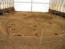
Roughly 1/20th of the Mukibanda remains have been excavated.[4] The 17.2 hectares (43 acres) of excavation revealed 395 pit-style dwellings, 502 dwellings with raised cornerstones, and 24 Yayoi-style barrow cliff tombs.[2] This area was inhabited between the late Yayoi to early Kofun period, roughly 100 BC to 300 AD.[4] The east part of the site was occupied by dwellings, and the western part of the site, on higher ground, was used for gravesites. The settlement was active in blacksmithing, bead making, and the production of earthenware pottery. The highest point on the site in the Matsuogashira district of Daisen appears to be the home of the chief of the village and home to the sacred area of the site.[2] The entire site is thought to be the chief village, and possibly capitol, of some type of political entity.[4]
Remains
Districts
The Mukibanda Yayoi remains are divided into seven districts.
- Sentani
- Muki Niiyama
- Mukiyama
- Matsuogashira
- Komaishi
- Shimizu
- Matsuojo[1]
Visiting the site
The Mukibanda remains are open to the public. Tours, demonstrations, special events, and reconstructions at the site can be seen throughout the year.[5]
Access
The Mukibanda remains are closest to the JR West San'in Main Line Yonago Station (15 minute bus ride), but is also accessible from the JR West San'in Main and Inbi lines at Tottori Station (2 hour bus ride). The site is accessible by road via the San'in Expressway, Japan National Route 431, and Japan National Route 9.[6]
Gallery
 Protected grave
 Mukiniiyama area
- Remains of a dwelling
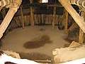 Reconstruction of a dwelling
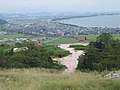 Donohara area
See also
References
- "Muki-Banda Remains". Archived from the original on 2012-09-04. Retrieved 2012-04-07.
- "Mukibanda-iseki (妻木晩田遺跡)". Nihon Rekishi Chimei Taikei (日本歴史地名大系 (in Japanese). Tokyo: Shogakukan. 2012. Archived from the original on 2007-08-25. Retrieved 2012-04-07.
- 史跡名勝天然記念物: 妻木晩田遺跡(in Japanese)
- 妻木晩田遺跡とは?(in Japanese)
- むきばんだ史跡公園のイベントカレンダー(in Japanese)
- むきばんだ史跡公園のアクセス(in Japanese)
External links
- Muki-Banda Remains
- Mukibanda Historical Site, Yonago Tourist Site
- 妻木晩田遺跡 史跡名勝記念物(in Japanese)
- Visitors' brochure(in Japanese)
- 大阪府立弥生文化博物館 (Museum of Yayoi Culture, Osaka)(in Japanese)