Mugdrum Island
Mugdrum Island lies in the Firth of Tay, offshore from the town of Newburgh, Fife, in the east of Scotland.[3]
| Gaelic name | muc-dhruim |
|---|---|
| Meaning of name | hog-back |
| Location | |
 Mugdrum Island Mugdrum Island shown within Scotland | |
| OS grid reference | NO225189 |
| Coordinates | 56.36°N 3.25°W |
| Physical geography | |
| Island group | River Tay |
| Area | 32 ha |
| Highest elevation | 4 m |
| Administration | |
| Sovereign state | United Kingdom |
| Country | Scotland |
| Council area | Fife |
| Demographics | |
| Population | 0 |
| References | [1][2] |
Geography
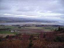
Mugdrum is low-lying and reedy, with the "North Deep" and "South Deep" channels on either side of the island. It covers an area of 32 acres (130,000 m2).[3]
History
Mugdrum's name is from muc-dhruim, the Scottish Gaelic for hog-back. The name is also applied to Mugdrum House[4], to the west of Newburgh in Fife, on the south coast of the Tay opposite the island.[3]
The reeds were once harvested for thatching and for protecting potatoes during transshipment. Until 1926, a 50-acre (200,000 m2) farm grew cereals, potatoes and turnips in the island's alluvial soil. It is now a nature reserve under the stewardship of the Tay Valley Wildfowlers' Association.
The Laing Museum in Newburgh preserves the stuffed body of a two-headed kitten born in the 19th century on Mugdrum.
See also
References
- 2001 UK Census per List of islands of Scotland
- Ordnance Survey
- "Historical perspective for Mugdrum Island". Gazetteer for Scotland. Retrieved 2008-10-05.
- https://canmore.org.uk/site/104391/mugdrum-house