Mudeungsan
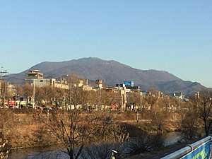
Mudeungsan (무등산) is a mountain in South Korea. It extends over the district of Buk-gu in the city of Gwangju, Hwasun County and Damyang County in the province of Jeollanam-do. Mudeungsan has an elevation of 1,187 m (3,894 ft).[2] Mudeungsan is a part of Mudeungsan National Park,[1] which gained national park status in 2012.[3] The summit of Mudeungsan is named Cheonwang summit. However, after being designated as a protection zone for air force military installations, the highest spot climbers can ascend without special permission is Seoseokdae Rock at an elevation of 1,100 m (3,609 ft).[4]
| Mudeungsan | |
|---|---|
 | |
| Highest point | |
| Elevation | 1,187[1] m (3,894 ft) |
| Coordinates | 35°08′21″N 126°59′33″E |
| Geography | |
 Mudeungsan | |
| Climbing | |
| Korean name | |
| Hangul | |
| Hanja | |
| Revised Romanization | Mudeungsan |
| McCune–Reischauer | Mutŭngsan |
Looking from the summit, Hallasan in Jejudo, and Geojedo in Namhae, Gyeongsangnam-do Province can be seen.[5]
Name

The mountain was known as "Moo Ak" or "Moo Jin Ak" due to its location in Moo Jin Joo, the former name for Gwangju. As most of the big mountain ranges are related to shamanism, it was also called "the Grave Mountain" or "the Shaman Mountain". The Moodeungsan range is primally composed of soil rather than rocks. It was called "Seo Seok" mountain during the Goryeo dynasty. It was after the introduction to Buddhism in Korea that it was called "Moodeung san". People believed the grand tower of the mountain cannot be compared to the mankind. This is interpreted through understanding the roots of the name through Chinese "Hanja." The name comes from Gwangju's original name, Moodeul or Moodol. The "Jin" in Moojin is read through the Chinese roots in characters, but in the past, Deul or Dol is read through native roots in Korean. Moo Deung is also similar transliteration. There is also a placed called "Soo Ip ee" so there are more circumstantial evidences.[6]
History
On 22 May 1972, Mudeungsan was designated as a provincial park. On 29 April 1974, the government notified a basic park plan (the 61st notification of Jeollanamdo). On 1 September 1987, the government installed the Mudeungsan Park Administrative Office. On 24 September 1998, the government established a comprehensive plan about conservation and use of Mudeungsan. On 7 December 2001, the government changed the basic park plan. On 24 December 2010, the city of Gwangju filed a petition to the minister of environment to designate Mudeungsan as a national park. On 31 December 2012, Mudeungsan was designated as a national park. On 4 March 2013, the government installed Mudeungsan national park office and east office. On 3 December 2015, the government notified withdrawal of military bases.[7]
Provincial and national park
Mudeungsan was designated as a provincial park in 1972. It is located at the city of Gwangju, Hwasun County and Damyang County. It has a total area of 30.23 km2 (11.67 sq mi)[8] In 2012, it was designated as a national park, expanded to a total area of 75.425 km2 (29.122 sq mi).[7] However, Gwangju lake area and some cultural areas were excluded from national park, due to the opposition from local government and residents.[9]
Natural monument
Jusangjeolli Cliff of Mudeungsan Mountain is protected as natural monument No. 465.[10][11]
There are many valuable animals such as otters, wildcats, buzzards and Mandarin ducks, designated as endangered at Mudeungsan. In addition, there are many cultural heritages.[12]
Summits
In 2011, after 45 years of being restricted by the military, Inwang summit and Jiwang summit were opened to the public. However, Cheongwang summit remained closed due to air defense facilities. Only those identified and approved by the military after learning about security-related subjects from Jangbuljae can go there.[13] It was opened twice in 2011; quarterly in 2012 and 2013; once in 2014;[14] and three times in 2015.[15]
Environment
The Sobaek Mountains are the main range of Mudeungsan. Mudeungsan has a gradual descent toward the ground. Average temperature for the year is 13.2 °C (55.8 °F) which is 5 °C (9 °F) below that of downtown of Gwangju. Average rainfall for the year is about 1,500 mm (59 in), which is more than 200 mm (7.9 in) above what is received in downtown Gwangju. The sky is clear 53 days per year.[16]
Tourist attractions
See also
- List of mountains in Korea
- National parks of South Korea
- Jeungsimsa temple
- Wonhyosa temple
References
- "Mudeungsan National Park". Lonely Planet. Retrieved 2016-01-17.
- Yu Jeong-yeol (2007). 한국의 산 여행 (Travel Guide to Korean Mountains). Seoul: 관동 상억연구회 (Kwandong). p. 441. ISBN 978-89-958055-1-0.
- "Korean National Park Service" (in Korean). Retrieved 3 November 2013.
- "무등산국립공원 - 정상개방으로 천왕봉과 하늘이 열리던 날". 광주광역시 공식블로그 (in Korean). 광주광역시.
- "무등산의 경관". 무등산권지질공원 (in Korean).
- "무등산". terms.naver.com. Retrieved 2015-12-13.
- "산/사찰 - 무등산". 광주광역시 문화관광포털. Archived from the original on 2015-12-22.
- "무등산소개". 무등산펜션.
- "무등산 21번째 국립공원 됐다...24년만의 신규지정(종합) | 연합뉴스". www.yonhapnews.co.kr. Retrieved 2015-12-21.
- "천연기념물". 국립공원관리공단. Archived from the original on 2015-12-22.
- "Jusangjeolli Cliff of Mudeungsan Mountain (무등산 주상절리대) - Official Korea Tourism Organization". English.visitkorea.or.kr. Retrieved 2016-01-17.
- 손, 정호 (2012-12-28). "무등산 국립공원 지정, 천연기념물-보물 등 많아".
- "무등산 정상 45년만에 열린다". www.hani.co.kr. Retrieved 2015-12-13.
- "Daum 카페". cafe.daum.net. Retrieved 2015-12-21.
- "11월7일 무등산 정상 개방". www.asiae.co.kr. Retrieved 2015-12-21.
- "무등산국립공원-자연환경". 무등산펜션.
- "주변관광지". 무등산펜션.