Mount Vaca
Mount Vaca is a mountain in Napa and Solano counties of Northern California. It is both the highest point in the Vaca Mountains and in Solano County.[3] It is also one of several peaks in the San Francisco Bay Area that receive winter snow.
| Mount Vaca | |
|---|---|
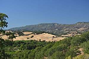 Mt. Vaca and the Blue Ridge, high points of Solano County, as seen from upper Suisun Valley. | |
| Highest point | |
| Elevation | 2,822 ft (860 m) NAVD 88[1] |
| Prominence | 1,959 ft (597 m) [1] |
| Listing | California county high points 53rd |
| Coordinates | 38°24′01″N 122°06′22″W[2] |
| Geography | |
 Mount Vaca | |
| Location | Napa and Solano counties, California, U.S. |
| Parent range | Vaca Mountains |
| Topo map | USGS Mount Vaca |
Origin of name
Vaca is the Spanish word for cow. Although cattle ranching historically played an important role in the area, Mount Vaca and the nearby city of Vacaville are actually named for Juan Manuel Cabeza Vaca (1782-1856), who with Juan Felipe Pena received in 1843 the Rancho Los Putos Mexican land grant, which included the peak that now bears Vaca's name.[4]
Public access
The summit of Mount Vaca is reached via either Mix Canyon Road or Gates Canyon Road, both of which originate in Vacaville California.[5] These roads intersect Blue Ridge Road, which follows the ridge top to the summit high point.
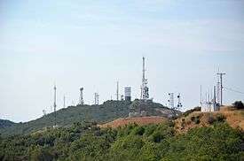
High-definition Doppler weather radar
The San Francisco Bay Area is surrounded by mountain ranges that obstruct weather radar, even government broadcasts, thereby leaving blind spots in the weather prediction system. As a consequence, television station KPIX-TV, a San Francisco CBS affiliate, partnered with the National Oceanic and Atmospheric Administration (NOAA) to build a Doppler weather radar on top of Mt. Vaca. Before this, the mountain blocked radar information about storms coming in from the Northwest, which compromised weather prediction and allowed for flooding, heavy rains, and high winds without prior warnings. This new radar system gives meteorologists a more complete view of precipitation and temperature patterns in the Bay Area, and allows for more accurate weather predictions.[6]
See also
References
- "Mount Vaca, California". Peakbagger.com. Retrieved 15 July 2009.
- "Mount Vaca". Geographic Names Information System. United States Geological Survey. Retrieved 17 July 2009.
- "California County High Points". Peakbagger.com. Retrieved 9 December 2009.
- Gudde, Erwin G. (1949). California Place Names. Berkeley, CA: Univ. of California Press. p. 375.
- Information on road access is from the Solano County Surveyors Office in Fairfield, California, personal communication, 17 July 2009.
- National Oceanographic and Atmospheric Agency (2007). "NOAA Agencies partner with the private sector to provide high resolution Doppler Radar data to San Francisco Bay Area Forecast Office (press release)" (PDF). Hydrometeorology Testbed (HMT) website. Retrieved 15 June 2013.