Mount Rushmore
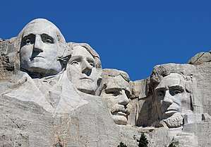
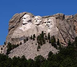
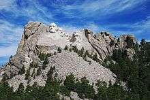
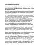
Mount Rushmore National Memorial is centered on a sculpture carved into the granite face of Mount Rushmore in the Black Hills in Keystone, South Dakota, United States. Sculptor Gutzon Borglum created the sculpture's design and oversaw the project's execution from 1927 to 1941 with the help of his son Lincoln Borglum.[2][3] The sculpture features the 60-foot (18 m) heads of Presidents George Washington (1732–1799), Thomas Jefferson (1743–1826), Theodore Roosevelt (1858–1919), and Abraham Lincoln (1809–1865), as recommended by Borglum.[4] The four presidents were chosen to represent the nation's birth, growth, development, and preservation, respectively.[5] The memorial park covers 1,278.45 acres (2.00 sq mi; 5.17 km2)[6] and is 5,725 feet (1,745 m) above sea level.[7]
| Mount Rushmore National Memorial | |
|---|---|
IUCN category III (natural monument or feature) | |
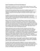
.jpg) Mount Rushmore with sculptures of George Washington, Thomas Jefferson, Theodore Roosevelt, and Abraham Lincoln (left to right) | |
 | |
| Location | Pennington County, South Dakota |
| Nearest city | Keystone, South Dakota |
| Coordinates | 43°52′44″N 103°27′35″W |
| Area | 1,278 acres (5.17 km2) |
| Authorized | March 3, 1925 |
| Visitors | 2,431,231 (in 2016)[1] |
| Governing body | National Park Service |
| Website | Mount Rushmore National Memorial |
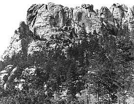
South Dakota historian Doane Robinson is credited with conceiving the idea of carving the likenesses of noted figures into the mountains of the Black Hills of South Dakota in order to promote tourism in the region. His initial idea was to sculpt the Needles; however, Gutzon Borglum rejected the Needles because of the poor quality of the granite and strong opposition from the Lakota (Sioux), who consider the Black Hills to be sacred ground; it was originally included in the Great Sioux Reservation. The United States broke up the territory after gold was discovered in the Black Hills.
The sculptor and tribal representatives settled on Mount Rushmore, which also has the advantage of facing southeast for maximum sun exposure. Robinson wanted it to feature American West heroes, such as Lewis and Clark, their expedition guide Sacagawea, Oglala Lakota chief Red Cloud,[8] Buffalo Bill Cody,[9], and Oglala Lakota chief Crazy Horse.[10] Borglum believed that the sculpture should have broader appeal and chose the four presidents.
Peter Norbeck, the US Senator from South Dakota, sponsored the project and secured federal funding.[11] Construction began in 1927, and the presidents' faces were completed between 1934 and 1939. After Gutzon Borglum died in March 1941, his son Lincoln took over as leader of the construction project. Each president was originally to be depicted from head to waist, but lack of funding forced construction to end on October 31, 1941.[12]
Sometimes referred to as the "Shrine of Democracy",[13][14] Mount Rushmore attracts more than two million visitors annually.[1]
History
Although Mount Rushmore was constructed with the intention of symbolizing "the triumph of modern society and democracy",[15] for the original land occupants, the Lakota Sioux, the monument embodies a story of "struggle and desecration".[16] The U.S. Government promised the Sioux territory, including the perpetuity of the Black Hills in the Treaty of 1868. That lasted only until the discovery of gold on the land and soon after white settlers migrated to the area in the 1870s. The federal government then forced the Sioux to relinquish the Black Hills portion of their reservation.[16] The battle that took place in 1890 between the US Army and the Native Americans is known as the Wounded Knee Massacre, "where hundreds of unarmed Sioux women, children, and men were shot and killed by U.S. troops", as summarized by PBS regarding historian Dee Brown's account of the event.[16]
The four presidential faces were carved into the granite with the intention of symbolizing "an accomplishment born, planned, and created in the minds and by the hands of Americans for Americans".[17]
Naming
Originally known to the Lakota Sioux as "The Six Grandfathers" (Tȟuŋkášila Šákpe) or "Cougar Mountain" (Igmútȟaŋka Pahá);[18][19] American settlers knew it variously as Cougar Mountain, Sugarloaf Mountain, Slaughterhouse Mountain, and Keystone Cliffs. As Six Grandfathers, the mountain was part of the route that Lakota leader Black Elk took in a spiritual journey that culminated at Black Elk Peak. Following a series of military campaigns from 1876 to 1878, the United States asserted control over the area, a claim that is still disputed on the basis of the 1868 Treaty of Fort Laramie (see section "Controversy" below).
Beginning with a prospecting expedition in 1885 with David Swanzey (husband of Carrie Ingalls), and Bill Challis, wealthy investor Charles E. Rushmore began visiting the area regularly on prospecting and hunting trips. He repeatedly joked with colleagues about naming the mountain after himself.[20][21] The United States Board of Geographic Names officially recognized the name "Mount Rushmore" in June 1930.
Concept, design, and funding
Historian Doane Robinson conceived the idea for Mount Rushmore in 1923 to promote tourism in South Dakota. In 1924, Robinson persuaded sculptor Gutzon Borglum to travel to the Black Hills region to ensure the carving could be accomplished. The original plan was to make the carvings in granite pillars known as the Needles. However, Borglum realized that the eroded Needles were too thin to support sculpting. He chose Mount Rushmore, a grander location, partly because it faced southeast and enjoyed maximum exposure to the sun. Borglum said upon seeing Mount Rushmore, "America will march along that skyline."[22] Borglum had been involved in sculpting the Confederate Memorial Carving, a massive bas-relief memorial to Confederate leaders on Stone Mountain in Georgia, but was in disagreement with the officials there.[23]
After long negotiations involving a Congressional delegation and President Calvin Coolidge, the project received Congressional approval on March 3, 1925.[22] The carving started in 1927 and ended in 1941 with no fatalities.[24][25]
Construction
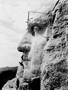
Between October 4, 1927, and October 31, 1941, Gutzon Borglum and 400 workers[27] sculpted the colossal 60-foot-high (18 m) carvings of United States Presidents George Washington, Thomas Jefferson, Theodore Roosevelt, and Abraham Lincoln to represent the first 130 years of American history. These presidents were selected by Borglum because of their role in preserving the Republic and expanding its territory.[22][28] The carving of Mount Rushmore involved the use of dynamite, followed by the process of "honeycombing", a process where workers drill holes close together, allowing small pieces to be removed by hand.[29] In total, about 450,000 short tons (400,000 long tons) of rock were blasted off the mountainside.[30] The image of Thomas Jefferson was originally intended to appear in the area at Washington's right, but after the work there was begun, the rock was found to be unsuitable, so the work on the Jefferson figure was dynamited, and a new figure was sculpted to Washington's left.[22]
The Chief Carver of the mountain was Luigi del Bianco, artisan and headstone carver in Port Chester, New York. Del Bianco emigrated to the U.S. from Friuli in Italy, and was chosen to work on this project because of his remarkable skill at etching emotions and personality into his carved portraits.[2][3]
In 1933, the National Park Service took Mount Rushmore under its jurisdiction. Julian Spotts helped with the project by improving its infrastructure. For example, he had the tram upgraded so it could reach the top of Mount Rushmore for the ease of workers. By July 4, 1934, Washington's face had been completed and was dedicated. The face of Thomas Jefferson was dedicated in 1936, and the face of Abraham Lincoln was dedicated on September 17, 1937. In 1937, a bill was introduced in Congress to add the head of civil-rights leader Susan B. Anthony, but a rider was passed on an appropriations bill requiring federal funds be used to finish only those heads that had already been started at that time.[31] In 1939, the face of Theodore Roosevelt was dedicated.[32]
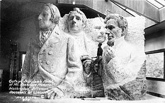
The Sculptor's Studio – a display of unique plaster models and tools related to the sculpting – was built in 1939 under the direction of Borglum. Borglum died from an embolism in March 1941. His son, Lincoln Borglum, continued the project. Originally, it was planned that the figures would be carved from head to waist,[33] but insufficient funding forced the carving to end. Borglum had also planned a massive panel in the shape of the Louisiana Purchase commemorating in eight-foot-tall gilded letters the Declaration of Independence, U.S. Constitution, Louisiana Purchase, and seven other territorial acquisitions from Alaska to Texas to the Panama Canal Zone.[28] In total, the entire project cost US$989,992.32.[34]
Nick Clifford, the last remaining carver, died in November 2019 at age 98.[35]
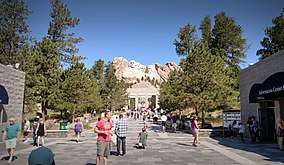

Visitor center
Harold Spitznagel and Cecil Doty designed the original visitor center, finished in 1957.[36] These structures were part of the Mission 66 effort to improve visitors' facilities at national parks and monuments across the country.[37]
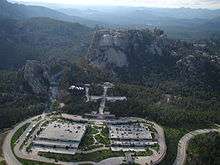
Ten years of redevelopment work culminated with the completion of extensive visitor facilities and sidewalks in 1998, such as a Visitor Center, the Lincoln Borglum Museum, and the Presidential Trail. Maintenance of the memorial requires mountain climbers to monitor and seal cracks annually. Due to budget constraints, the memorial is not regularly cleaned to remove lichens. However, on July 8, 2005, Alfred Kärcher GmbH, a German manufacturer of pressure washing and steam cleaning machines, conducted a free cleanup operation which lasted several weeks, using pressurized water at over 200 °F (93 °C).[38]
On October 15, 1966, Mount Rushmore was listed on the National Register of Historic Places. A 500-word essay giving the history of the United States by Nebraska student William Andrew Burkett was selected as the college-age group winner in a 1934 competition, and that essay was placed on the Entablature on a bronze plate in 1973.[31][39] In 1991, President George H. W. Bush officially dedicated Mount Rushmore.[40]
Tourism
| Year | Visitors |
|---|---|
| 1941 | 393,000 |
| 1950 | 740,499 |
| 1960 | 1,067,000 |
| 1970 | 1,965,700 |
| 1980 | 1,284,888 |
| 1990 | 1,671,673 |
| 2000 | 1,868,876 |
| 2010 | 2,331,237 |
Tourism is South Dakota's second-largest industry, and Mount Rushmore is the state's top tourist attraction.[41] In 2012, 2,185,447 people visited the park.[1]
In the 1950s and 1960s, local Lakota Sioux elder Benjamin Black Elk (son of medicine man Black Elk, who had been present at the Battle of the Little Bighorn) was known as the "Fifth Face of Mount Rushmore", posing for photographs with thousands of tourists daily in his native attire. The South Dakota State Historical Society notes that he was one of the most photographed people in the world over that twenty-year period.[42]
Hall of Records
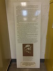
Borglum originally envisioned a grand Hall of Records where America's greatest historical documents and artifacts could be protected and shown to tourists. He managed to start the project, but cut only 70 feet (21 m) into the rock before work stopped in 1939 to focus on the faces. In 1998, an effort to complete Borglum's vision resulted in a repository being constructed inside the mouth of the cave housing 16 enamel panels that contained biographical and historical information about Mount Rushmore as well as the texts of the documents Borglum wanted to preserve there. The vault consists of a teakwood box (housing the 16 panels) inside of a titanium vault placed in the ground with a granite capstone.[43][44] The text found on the 16 panels can be found below.
Conservation
The ongoing conservation of the site is overseen by the National Park Service.[45] Physical efforts to conserve the monument have included replacement of the sealant applied originally by Gutzon Borglum, which had proved ineffective at providing water resistance. The components of Borglum's sealant included linseed oil, granite dust, and white lead, but a modern silicone replacement is now used, disguised with granite dust.
In 1998, electronic monitoring devices were installed to track movement in the topology of the sculpture to an accuracy of three millimeters. The site was digitally recorded in 2009 using a terrestrial laser scanning method as part of the international Scottish Ten project, providing a high resolution record to aid the conservation of the site. This data was made publicly accessible online.[46]
Ecology
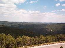
The flora and fauna of Mount Rushmore are similar to those of the rest of the Black Hills region of South Dakota. Birds including the turkey vulture, golden eagle, bald eagle, red-tailed hawk, swallows and white-throated swifts fly around Mount Rushmore, occasionally making nesting spots in the ledges of the mountain. Smaller birds, including songbirds, nuthatches, woodpeckers and flycatchers inhabit the surrounding pine forests.[47] Terrestrial mammals include the mouse, least chipmunk, red squirrel, skunk, porcupine, raccoon, beaver, badger, coyote, bighorn sheep, bobcat, elk, mule deer, yellow-bellied marmot, and American bison.[47][48] The striped chorus frog, western chorus frog, and northern leopard frog also inhabit the area,[49] along with several species of snake. Grizzly Bear Brook and Starling Basin Brook, the two streams in the memorial, support fish such as the longnose dace and the brook trout. Mountain goats are not indigenous to the region. Those living near Mount Rushmore are descendants of a tribe that Canada gifted to Custer State Park in 1924, which later escaped.[47][50][51]
At lower elevations, coniferous trees, mainly the ponderosa pine, surround most of the monument, providing shade from the sun. Other trees include the bur oak, the Black Hills spruce, and the cottonwood. Nine species of shrubs grow near Mount Rushmore. There is also a wide variety of wildflowers, including especially the snapdragon, sunflower, and violet. Towards higher elevations, plant life becomes sparser.[51] However, only approximately five percent of the plant species found in the Black Hills are indigenous to the region.[52]
The area receives about 18 inches (460 mm) of precipitation on average per year, enough to support abundant animal and plant life. Trees and other plants help to control surface runoff. Dikes, seeps, and springs help to dam up water that is flowing downhill, providing watering spots for animals. In addition, stones like sandstone and limestone help to hold groundwater, creating aquifers.[53]
A study of the fire scars present in tree ring samples indicates that forest fires occur in the ponderosa forests surrounding Mount Rushmore around every 27 years. Large fires are not common. Most events have been ground fires that serve to clear forest debris.[54] The area is a climax community. Recent pine beetle infestations have threatened the forest.[48]
Geography
Geology
Mount Rushmore is largely composed of granite. The memorial is carved on the northwest margin of the Black Elk Peak granite batholith in the Black Hills of South Dakota, so the geologic formations of the heart of the Black Hills region are also evident at Mount Rushmore. The batholith magma intruded into the pre-existing mica schist rocks during the Proterozoic, 1.6 billion years ago.[55] Coarse grained pegmatite dikes are associated with the granite intrusion of Black Elk Peak and are visibly lighter in color, thus explaining the light-colored streaks on the foreheads of the presidents.
The Black Hills granites were exposed to erosion during the Neoproterozoic, but were later buried by sandstone and other sediments during the Cambrian. Remaining buried throughout the Paleozoic, they were re-exposed again during the Laramide orogeny around 70 million years ago.[55] The Black Hills area was uplifted as an elongated geologic dome.[56] Subsequent erosion stripped the granite of the overlying sediments and the softer adjacent schist. Some schist does remain and can be seen as the darker material just below the sculpture of Washington.
The tallest mountain in the region is Black Elk Peak (7,242 ft or 2,207 m). Borglum selected Mount Rushmore as the site for several reasons. The rock of the mountain is composed of smooth, fine-grained granite. The durable granite erodes only 1 inch (25 mm) every 10,000 years, thus was more than sturdy enough to support the sculpture and its long-term exposure.[22] The mountain's height of 5,725 feet (1,745 m) above sea level[7] made it suitable, and because it faces the southeast, the workers also had the advantage of sunlight for most of the day.
Soils
The Mount Rushmore area is underlain by well drained alfisol soils of very gravelly loam (Mocmount) to silt loam (Buska) texture, brown to dark grayish brown.[57]
Climate
Mount Rushmore has a humid continental climate (Dwb in the Köppen climate classification). It is inside a USDA Plant Hardiness Zone of 5a, meaning certain plant life in the area can withstand a low temperature of no less than −20 °F (−29 °C).[58]
The two wettest months of the year are May and June. Orographic lift causes brief but strong afternoon thunderstorms during the summer.[59]
| Climate data for Mount Rushmore National Memorial, 1981-2011 normals | |||||||||||||
|---|---|---|---|---|---|---|---|---|---|---|---|---|---|
| Month | Jan | Feb | Mar | Apr | May | Jun | Jul | Aug | Sep | Oct | Nov | Dec | Year |
| Record high °F (°C) | 68 (20) |
68 (20) |
78 (26) |
85 (29) |
93 (34) |
99 (37) |
100 (38) |
99 (37) |
97 (36) |
86 (30) |
75 (24) |
67 (19) |
100 (38) |
| Average high °F (°C) | 36.3 (2.4) |
36.7 (2.6) |
43.2 (6.2) |
50.7 (10.4) |
60.7 (15.9) |
71.0 (21.7) |
79.1 (26.2) |
78.1 (25.6) |
67.8 (19.9) |
54.9 (12.7) |
42.9 (6.1) |
35.3 (1.8) |
54.7 (12.6) |
| Daily mean °F (°C) | 27.5 (−2.5) |
27.8 (−2.3) |
33.9 (1.1) |
41.4 (5.2) |
51.1 (10.6) |
61.1 (16.2) |
69.0 (20.6) |
67.9 (19.9) |
58.0 (14.4) |
45.7 (7.6) |
34.5 (1.4) |
26.7 (−2.9) |
45.4 (7.4) |
| Average low °F (°C) | 18.7 (−7.4) |
19.0 (−7.2) |
24.6 (−4.1) |
32.0 (0.0) |
41.6 (5.3) |
51.3 (10.7) |
58.9 (14.9) |
57.7 (14.3) |
48.2 (9.0) |
36.5 (2.5) |
26.0 (−3.3) |
18.1 (−7.7) |
36.0 (2.2) |
| Record low °F (°C) | −38 (−39) |
−29 (−34) |
−12 (−24) |
1 (−17) |
14 (−10) |
27 (−3) |
35 (2) |
33 (1) |
19 (−7) |
1 (−17) |
−12 (−24) |
−31 (−35) |
−38 (−39) |
| Average precipitation inches (mm) | 0.38 (9.7) |
0.70 (18) |
1.19 (30) |
2.23 (57) |
4.22 (107) |
3.41 (87) |
2.90 (74) |
1.99 (51) |
1.81 (46) |
1.68 (43) |
0.62 (16) |
0.43 (11) |
21.56 (549.7) |
| Average snowfall inches (cm) | 5.8 (15) |
7.9 (20) |
10.4 (26) |
10.8 (27) |
1.2 (3.0) |
0.1 (0.25) |
0.0 (0.0) |
0.0 (0.0) |
0.6 (1.5) |
3.6 (9.1) |
6.2 (16) |
5.8 (15) |
52.4 (132.85) |
| Average precipitation days (≥ 0.01) | 4.3 | 4.7 | 6.3 | 8.2 | 11.9 | 12.6 | 11.4 | 9.3 | 7.4 | 6.8 | 4.4 | 4.2 | 91.5 |
| Average snowy days (≥ 0.1) | 3.9 | 3.8 | 3.9 | 3.1 | 0.6 | 0.0 | 0.0 | 0.0 | 0.3 | 1.4 | 2.7 | 3.4 | 23.1 |
| Source 1: [60] | |||||||||||||
| Source 2: [61] | |||||||||||||
In popular culture
Because of its fame as a monument, Mount Rushmore has been depicted in multiple places in popular culture.
Controversy
The Treaty of Fort Laramie (1868) had granted the Black Hills to the Lakota people in perpetuity, but the United States took the area from the tribe after the Great Sioux War of 1876. Members of the American Indian Movement led an occupation of the monument in 1971, naming it "Mount Crazy Horse", and Lakota holy man John Fire Lame Deer planted a prayer staff on top of the mountain. Lame Deer said that the staff formed a symbolic shroud over the presidents' faces "which shall remain dirty until the treaties concerning the Black Hills are fulfilled."[62]
In 2004, Gerard Baker was appointed as superintendent of the park, the first and so far only Native American in that role. Baker stated that he will open up more "avenues of interpretation", and that the four presidents are "only one avenue and only one focus."[63] The Crazy Horse Memorial is being constructed elsewhere in the Black Hills to commemorate the Native American leader as a response to Mount Rushmore. Upon completion, it will be larger than Mount Rushmore and has the support of Lakota chiefs. The Crazy Horse Memorial Foundation has rejected offers of federal funds, but it is the subject of controversy, even among Native American tribes.[64]
Legacy and commemoration
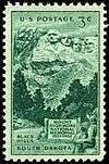

On August 11, 1952, the U.S. Post Office issued the Mount Rushmore Memorial commemorative stamp on the 25th anniversary of the dedication of the Mount Rushmore National Memorial.[65] On January 2, 1974, a stamp depicting the monument was also issued.[66] In 1991 the United States Mint released a commemorative silver dollar celebrating the 50th anniversary of the monument's dedication.[67]
See also


References
Notes
- "Park Statistics". National Park Service. Retrieved January 23, 2018.
- Roberts, Sam (June 28, 2016). "An Immigrant's Contribution to Mount Rushmore Is Recognized, 75 Years Later". New York Times. Retrieved September 19, 2017.
- Andrews, John (May 2014). "Slight of Hand". South Dakota Magazine. Retrieved September 22, 2017.
- Mount Rushmore National Memorial. December 6, 2005.60 SD Web Traveler, Inc. Retrieved April 7, 2006.
- "Why These Four Presidents?". nps.gov. National Park Service. Retrieved February 13, 2019.
- McGeveran, William A. Jr. et al. (2004). The World Almanac and Book of Facts 2004. New York: World Almanac Education Group, Inc. ISBN 0-88687-910-8.
- Mount Rushmore, South Dakota (November 1, 2004). Peakbagger.com. Retrieved March 13, 2006.
- '!, episode 5x08 "Mount Rushmore", May 10, 2007
- "Making Mount Rushmore | Mount Rushmore". Oh, Ranger!. Retrieved October 31, 2012.
- Pekka Hamalainen, "Lakota America, a New History of Indigenous Power," (New Haven: Yale University Press, 2019), p. 382
- "Biography:Senator Peter Norbeck". American Experience: Mount Rushmore. PBS. Retrieved July 20, 2013.
- "Mount Rushmore". American Experience – TV's Most Watched History Series. PBS. Retrieved April 18, 2015.
- Building 31, Mailing Address: 13000 Highway 244; Keystone, Suite 1; May, SD 57751 Phone:574-2523 Park information Phones are answered 7 days a week Hours are 8:00- 5:00 October through; mid-August, 8:00-10:00 June through; Us, 8:00-9:00 mid-August through September All times are Mountain Time Contact. "Thousands Celebrate at the Shrine of Democracy - Mount Rushmore National Memorial (U.S. National Park Service)". www.nps.gov.
- "Mount Rushmore". Travel South Dakota.
- Boime, Albert (Winter–Spring 1991). "Patriarchy Fixed in Stone". American Art. 5 (1/2). doi:10.1086/424112.
- "Native Americans and Mount Rushmore". PBS. Retrieved March 26, 2020.
- Boime, Albert. "Patriarchy Fixed in Stone": 142. doi:10.1086/424112. Cite journal requires
|journal=(help) - "Feature Detail Report for: Mount Rushmore". US Board on Geographic Names. February 13, 1980.
- "Untold Stories Discussion Guide: Baker and Mount Rushmore" (PDF). The National Parks: America's Best Idea. PBS. p. 2. Archived from the original (PDF) on October 18, 2015.
Mount Rushmore – a rocky outcropping the Lakota had called 'The Six Grandfathers,' named for the earth, the sky, and the four directions
- Keystone Area Historical Society Keystone Characters Archived September 9, 2006, at the Wayback Machine. Retrieved October 3, 2006.
- Belanger, Ian A.; Kennedy, Sally; Allison; McMeen, Melissa; Arnold, John (April 21, 2002). "Mt. Rushmore — presidents on the rocks". Archived from the original on May 14, 2006. Retrieved January 11, 2016.
- Carving History (October 2, 2004). National Park Service.
- "People & Events: The Carving of Stone Mountain". American Experience. PBS. Archived from the original on April 13, 2010. Retrieved March 17, 2010.
- "Mount Rushmore National Memorial Frequently Asked Questions". National Park Service. Retrieved December 2, 2009.
- Mount Rushmore National Memorial. Outdoorplaces.com. Retrieved June 7, 2006.
- "Rare Photos From The Past". p. 5. Archived from the original on January 19, 2016.
1941, the original mockup of Mt. Rushmore before funding ran out.
- "Carving History". National Park Service. Retrieved February 22, 2013.
- Albert Boime, "Patriarchy Fixed in Stone: Gutzon Borglum's 'Mount Rushmore'," American Art, Vol. 5, No. 1/2. (Winter – Spring, 1991), pp. 142–67.
- "Honeycombing process explained from". nps.gov. June 14, 2004. Archived from the original on August 1, 2008. Retrieved March 20, 2010.
- "Geology Fieldnotes". nps.gov. January 4, 2005. Retrieved October 22, 2010.
- American Experience "Timeline: Mount Rushmore" (2002). Retrieved March 20, 2006.
- Cope, Willard (July 7, 1939). "Remember Stone Mountain's Mighty Memorial?". The Atlanta Constitution. Atlanta, Georgia. p. 9 – via Newspapers.com.
- Mount Rushmore National Memorial.
- Mount Rushmore National Memorial Archived February 24, 2006, at the Wayback Machine. Tourism in South Dakota. Laura R. Ahmann. Retrieved March 19, 2006.
- Reagan, Nick (November 23, 2019). "Last carver of Mount Rushmore dies at 98". www.kotatv.com. Retrieved November 26, 2019.
- Lathrop, Alan K. (Winter 2007). "Designing for South Dakota and the Upper Midwest: The Career of Architect Harold T. Spitznagel, 1930—1974" (PDF). South Dakota History. 37 (4): 271–305.
- Allaback, Sarah (2000). "Mission 66 Visitor Centers: The History of a Building Type". National Park Service.
- "For Mount Rushmore, An Overdue Face Wash". Washington Post. July 11, 2005. Retrieved March 17, 2010.
- "Text of 1934 Essay – History of the United States" (PDF). Retrieved August 27, 2017.
- "George Bush: Remarks at the Dedication Ceremony of the Mount Rushmore National Memorial in South Dakota". The American Presidency Project. July 3, 1991. Retrieved August 27, 2017.
- "Popular South Dakota Attractions >>South Dakota". southdakota.com. Retrieved March 21, 2015.
- Kilen Ode, Jeanne (1984). Dakota Images: Benjamin Black Elk (PDF). 14. South Dakota State Historical Society.
- "Hall of Records". Mount Rushmore National Memorial web site. National Park Service. June 14, 2004. Archived from the original on October 11, 2007. Retrieved July 4, 2007.
- Building 31, Mailing Address: 13000 Highway 244; Keystone, Suite 1; May, SD 57751 Phone:574-2523 Park information Phones are answered 7 days a week Hours are 8:00- 5:00 October through; mid-August, 8:00-10:00 June through; Us, 8:00-9:00 mid-August through September All times are Mountain Time Contact. "Hall of Records - Mount Rushmore National Memorial (U.S. National Park Service)". www.nps.gov.
- "Caring For A Monumental Sculpture" (PDF). National Park Service. Retrieved July 8, 2013.
- "Mount Rushmore National Memorial". CyArk. Retrieved July 8, 2013.
- "Enjoy Wildlife......Safely" (PDF). National Park Service. National Park Service. Retrieved January 4, 2014.
- Freeman, Mary. "Mount Rushmore, South Dakota for Tourists". USA Today. Tysons Corner, VA: Gannett Company. Retrieved January 3, 2014.
- "Amphibians". National Park Service. National Park Service. Retrieved January 4, 2014.
- "Nature & Science- Animals". NPS. November 26, 2006. Retrieved March 17, 2010.
- "Mount Rushmore- Flora and Fauna". American Park Network. 2001. Archived from the original on December 12, 2007. Retrieved January 11, 2016.
- "Nature & Science – Plants". NPS. December 6, 2006. Retrieved March 17, 2010.
- Nature & Science- Groundwater. National Park Service. Retrieved April 1, 2006.
- Nature & Science- Forests. National Park Service. Retrieved April 1, 2006.
- Geologic Activity. National Park Service.
- Irvin, James R. Great Plains Gallery Archived July 20, 2006, at the Wayback Machine (2001). Retrieved March 16, 2006.
- "SoilWeb: An Online Soil Survey". University of California, Davis. Retrieved August 27, 2017.
- "USDA Hardiness Zone Finder". The National Gardening Association. National Gardening Association. Retrieved January 3, 2014.
- "Weather History". National Park Service, U.S. Department of the Interior. June 23, 2004. Archived from the original on July 6, 2008. Retrieved January 27, 2013.
- "Monthly Averages for Mount Rushmore Natl Memorial, SD". The Weather Channel. Retrieved January 3, 2014.
- "NOWData – NOAA Online Weather Data". National Oceanic and Atmospheric Administration. Retrieved January 3, 2014.
- Matthew Glass, "Producing Patriotic Inspiration at Mount Rushmore," Journal of the American Academy of Religion, Vol. 62, No. 2. (Summer, 1994), pp. 265–283.
- David Melmer (December 13, 2004). "Historic changes for Mount Rushmore". Indiancountrytoday. Archived from the original on August 8, 2010. Retrieved March 17, 2010.
- Lame Deer, John (Fire) and Richard Erdoes. Lame Deer Seeker of Visions. Simon and Schuster, New York, New York, 1972. Paperback ISBN 0-671-55392-5
- "3c Mt. Rushmore single". Smithsonian National Postal Museum. Retrieved July 1, 2014.
- Scotts United States Stamp catalogue, 1982. Scott's Publishing Company. 1981. ISBN 0-89487-042-4., p. 289.
- "1991 Mount Rushmore Silver Dollar". Modern Commemmoratives. Retrieved February 28, 2020.
Further reading
- Larner, Jesse. Mount Rushmore: An Icon Reconsidered New York: Nation Books, 2002.
- Taliaferro, John. Great White Fathers: The Story of the Obsessive Quest to Create Mount Rushmore. New York: PublicAffairs, c2002. ISBN 9781586482053. Puts the creation of the monument into a historical and cultural context.
- Coutant, Arnaud, Les Visages de l'Amérique, les constructeurs d'une démocratie fédérale, Mare et Martin, 2014 (ISBN 9782849341605). French Study about the Four Presidents, Life, presidency, influence about American political evolution. (Archived link)
- The National Parks: Index 2001–2003. Washington: United States Department of the Interior
- "Making Mount Rushmore". Oh, Ranger!. APN Media. Retrieved January 27, 2013.
- Dobrzynski, Judith H. (July 15, 2006). "A Monumental Achievement". Wall Street Journal. Retrieved January 27, 2013.
- Buckingham, Matthew (Summer 2002). "The Six Grandfathers, Paha Sapa, in the Year 502,002 C.E." Cabinet Magazine. Immaterial Incorporated. Retrieved January 27, 2013.
- "Luigi Del Bianco: chief stone carver on Mount Rushmore, 1933–1940". Lou Del Bianco. Retrieved January 27, 2013.
- "Caring For A Monumental Sculpture". National Park Service. Retrieved July 8, 2013.
External links
| Topics | |
|---|---|
| Lists by state |
|
| Lists by insular areas | |
| Lists by associated state | |
| Other areas | |
| Related | |
| |
| Authority control |
|
|---|