Mount Kosciusko (Antarctica)
Mount Kosciusko is a mountain, rising to 2,910 metres (9,550 ft), that comprises the central portion of the Ames Range in Marie Byrd Land, Antarctica. It was mapped by the United States Geological Survey from surveys and U.S. Navy air photos, 1959–65, and was named by the Advisory Committee on Antarctic Names for Captain Henry M. Kosciusko, U.S. Navy, Commander of the Antarctic Support Activities group, 1965–67.[1]
| Mount Kosciusko | |
|---|---|
 Mount Kosciusko Position in Antarctica | |
| Highest point | |
| Elevation | 2,910 m (9,550 ft) |
| Coordinates | 75°43′S 132°13′W |
| Geography | |
| Location | Marie Byrd Land, Antarctica |
| Parent range | Ames Range |
| Geology | |
| Mountain type | Shield volcano |
| Volcanic field | Marie Byrd Land Volcanic Province |
It is connected to Mount Kauffman by Gardiner Ridge which is at one end of Brown Valley.
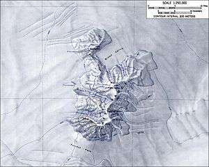
Topographic map of the Ames Range (1:250,000 scale) from USGS Mount Kosciusko
References
- "Mount Kosciusko". Geographic Names Information System. United States Geological Survey. Retrieved 2013-05-14.
![]()
This article is issued from Wikipedia. The text is licensed under Creative Commons - Attribution - Sharealike. Additional terms may apply for the media files.