Mount Kanaga
Mount Kanaga is a stratovolcano at the northern tip of Kanaga Island in the Aleutian Islands, Alaska. It is situated within a caldera, which forms the arcuate Kanaton Ridge south and east of Kanaga. A crater lake occupies part of the SE caldera floor. The summit of Kanaga has a crater with fumarolic activity.
| Mount Kanaga | |
|---|---|
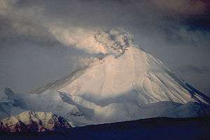 View, looking west to Kanaga Volcano in 1994 eruption. | |
| Highest point | |
| Elevation | 4,288 ft (1,307 m) |
| Prominence | 1,307 m (4,288 ft) |
| Coordinates | 51°55′24″N 177°10′05″W |
| Geography | |
| Location | Kanaga Island, Alaska, U.S. |
| Parent range | Aleutian Range |
| Topo map | USGS Adak C-4 |
| Geology | |
| Mountain type | Stratovolcano |
| Volcanic arc/belt | Aleutian Arc |
| Last eruption | February 2012 |
It is located about 25 km (16 mi) west of the U.S. Navy installation and port on Adak Island. The volcano erupted intermittently through much of 1994, dusting the community of Adak at least once with fine ash.
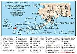
Map showing volcanoes of Alaska. The mark is set at the location of Mount Kanaga.
Gallery
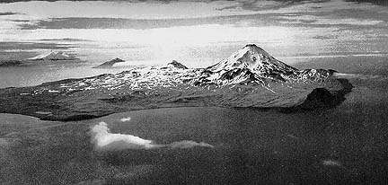 Aerial photograph of Kanaga Island produced in 1952 by the United States Navy
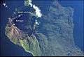 Kanaga Island with Mount Kanaga seen from space
 Kanaga Volcano, Kanaga Island, Aleutians
.jpg) Lava flow formed by 1906 eruption of Mount Kanaga
Lava flow formed by 1906 eruption of Mount Kanaga
See also
- List of volcanoes in the United States of America
Sources
- "Kanaga". Global Volcanism Program. Smithsonian Institution.
- Volcanoes of the Alaska Peninsula and Aleutian Islands-Selected Photographs
- Alaska Volcano Observatory
This article is issued from Wikipedia. The text is licensed under Creative Commons - Attribution - Sharealike. Additional terms may apply for the media files.