Mount Foster
Mount Foster is a peak rising to 2,105 metres (6,906 ft) in the Imeon Range on Smith Island in the South Shetland Islands, Antarctica. It is the highest point of the South Shetland Islands archipelago. Mount Foster has triple peaks of which Mount Foster proper is the southernmost, the central one is Evlogi Peak (2090 m), and the northern one is Antim Peak (2070 m).[2] The first ascent was made by Greg Landreth and team on 29 January 1996.[3]
| Mount Foster | |
|---|---|
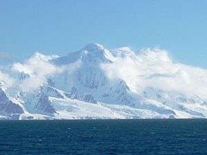 Mount Foster with twin Evlogi Peak, and Antim Peak on the right. | |
| Highest point | |
| Elevation | 2,105 m (6,906 ft) [1] |
| Prominence | 2,105 m (6,906 ft) [1] |
| Listing | Ultra |
| Coordinates | 62°59′48″S 62°32′55″W |
| Geography | |
 Mount Foster Location in Antarctica | |
| Location | Smith Island, Antarctica |
| Parent range | Imeon Range |
| Climbing | |
| First ascent | Greg Landreth, 1996 |
The feature is named after Captain Henry Foster, commander of HMS Chanticleer who explored the South Shetlands in 1829.
Location
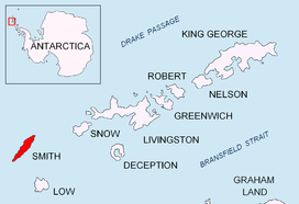
Mount Foster is linked by Zavet Saddle to Slaveykov Peak to the southwest and surmounts Bistra Glacier to the west, Chuprene Glacier to the north-northwest, Rupite Glacier to the east, Landreth Glacier to the southeast and Dragoman Glacier to the south-southeast. The peak is located 5.45 km northeast of Riggs Peak, 2.78 km south-southeast of Garmen Point, 7.64 km southwest of Mount Pisgah and 3.86 km north-northwest of Ivan Asen Point (Bulgarian mapping in 2009).
Maps
- Chart of South Shetland including Coronation Island, &c. from the exploration of the sloop Dove in the years 1821 and 1822 by George Powell Commander of the same. Scale ca. 1:200000. London: Laurie, 1822.
- L.L. Ivanov. Antarctica: Livingston Island and Greenwich, Robert, Snow and Smith Islands. Scale 1:120000 topographic map. Troyan: Manfred Wörner Foundation, 2010. ISBN 978-954-92032-9-5 (First edition 2009. ISBN 978-954-92032-6-4)
- South Shetland Islands: Smith and Low Islands. Scale 1:150000 topographic map No. 13677. British Antarctic Survey, 2009.
- Antarctic Digital Database (ADD). Scale 1:250000 topographic map of Antarctica. Scientific Committee on Antarctic Research (SCAR). Since 1993, regularly upgraded and updated.
- L.L. Ivanov. Antarctica: Livingston Island and Smith Island. Scale 1:100000 topographic map. Manfred Wörner Foundation, 2017. ISBN 978-619-90008-3-0
References
- "Antarctica Ultra-Prominences" Peaklist.org. Retrieved 2011-12-24.
- L.L. Ivanov. Antarctica: Livingston Island and Greenwich, Robert, Snow and Smith Islands. Scale 1:120000 topographic map. Troyan: Manfred Wörner Foundation, 2010. ISBN 978-954-92032-9-5 (First edition 2009. ISBN 978-954-92032-6-4)
- News from Antarctica: Mount Foster’s first ascent. Archived 2001-01-16 at the Wayback Machine
Other sources
