Mount Andrus
Mount Andrus is a shield volcano 3.2 km (2 mi) SE of Mount Boennighausen in the SE extremity of Ames Range, in Marie Byrd Land, Antarctica. Mapped by USGS from surveys and U.S. Navy air photos, 1964–68. Named by US-ACAN for Lt. Carl H. Andrus, US Navy, medical officer and Officer-in-Charge of Byrd Station in 1964.
| Mount Andrus | |
|---|---|
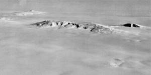 Aerial view of the Ames range. Mount Andrus is the first mount from the right, excluding Mount Berlin, that can be seen isolated far away | |
| Highest point | |
| Elevation | 2,978 m (9,770 ft) |
| Coordinates | 75°48′0″S 132°18′0″W |
| Geography | |
 Mount Andrus | |
| Parent range | Ames Range |
| Geology | |
| Age of rock | Unknown |
| Mountain type | Shield volcano |
| Volcanic field | Marie Byrd Land Volcanic Province |
| Last eruption | Unknown |
Andrus has a 4.5 km-wide caldera at its summit. Weak fumarolic activity was detected in 1977 at Mt. Kauffman in the northern end of the Ames Range of which Mt. Andrus is the southernmost volcano.
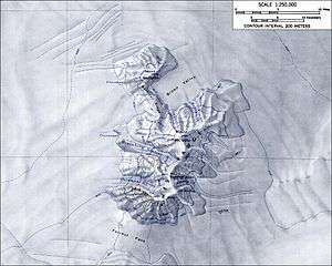
The westward face of Mt. Andrus is drained by the Coleman Glacier, with significant crevassing present.
In an interesting side note, Mt. Andrus was reportedly climbed by one Michael J. Andrus (no relation to Carl H. Andrus) in August 2006 for the purpose of downhill skiing, which would make him the first Andrus to visit the mountain (though perhaps not the last). Carl H. Andrus is himself an avid mountain climber, having summited all 46 of the Adirondack high peaks and having, in his youth, climbed the Matterhorn.
See also
References
- "Andrus". Global Volcanism Program. Smithsonian Institution.
- LeMasurier, W. E.; Thomson, J. W. (eds.) (1990). Volcanoes of the Antarctic Plate and Southern Oceans. American Geophysical Union. p. 512 pp. ISBN 0-87590-172-7.CS1 maint: extra text: authors list (link)
External links
- https://web.archive.org/web/20051030114935/http://usarc.usgs.gov/antarctic_atlas/
- http://www.skimountaineer.com/