Moulton Rural District
Moulton was a rural district in Suffolk, England from 1894 to 1935. It covered the area to the east of the town of Newmarket.
| Moulton | |
|---|---|
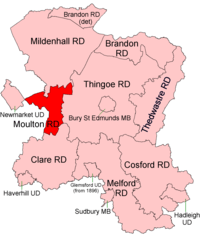 Location within West Suffolk, 1894 | |
| History | |
| • Created | 1894 |
| • Abolished | 1935 |
| • Succeeded by | Mildenhall & Clare RDs |
| Status | Rural district |
The district was created in 1894 as the part of the Newmarket rural sanitary district which lay in West Suffolk, the Cambridgeshire part becoming Newmarket Rural District.[1]
It was abolished in 1935 and most of the district (the parishes of Dalham, Gazeley, Higham Green and Moulton) became part of Mildenhall Rural District, which merged with Newmarket urban district in 1974 to create the modern Forest Heath district. The parishes of Lidgate and Ousden instead became part of Clare Rural District in 1935, and are now in neighbouring St Edmundsbury.
Statistics
| Year | Area[2] | Population [3] |
Density (pop/ha) | |
|---|---|---|---|---|
| acres | ha | |||
| 1911 | 14,601 | 5,909 | 8,311 | 1.41 |
| 1921 | 7,990 | 1.35 | ||
| 1931 | 7,815 | 1.32 | ||
References
- "Moulton RD through time: Census tables with data for the Local Government District". A Vision of Britain through Time. GB Historical GIS / University of Portsmouth. Retrieved 8 July 2017.
- "Moulton RD through time: Population Statistics: Area (acres)". A Vision of Britain through Time. GB Historical GIS / University of Portsmouth. Retrieved 8 July 2017.
- "Moulton RD through time: Population Statistics: Total Population". A Vision of Britain through Time. GB Historical GIS / University of Portsmouth. Retrieved 8 July 2017.
This article is issued from Wikipedia. The text is licensed under Creative Commons - Attribution - Sharealike. Additional terms may apply for the media files.