Mouchoir Bank
Mouchoir Bank, in Spanish also called Banco de Pañuelo Blanco, is a submerged bank that is disputed by the Turks and Caicos Islands and the Dominican Republic, and claimed by both countries as part of their EEZ.
| Native name: Banco de Pañuelo Blanco Submerged bank | |
|---|---|
 Mouchoir Bank Location with the Caribbean | |
| Geography | |
| Location | Caribbean |
| Coordinates | 20°57′00″N 70°42′00″W |
| Area | 960 km2 (370 sq mi) |
| Administration | |
| Additional information | |
| Time zone |
|
.jpg)
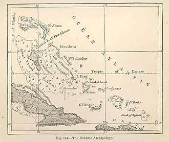
It is located southeast of the Turks islands and is geographically a continuation of the carbonate island archipelago comprising the Bahamas, Turks and Caicos Islands, the Silver Bank, and the Navidad Bank.[1]
Geography
Much of the north side of the bank is awash in two groupings of coral reef. A 1.8 m deep rock lies between the two groupings. There are numerous shallow patches on the bank which break. North East Breaker is a dangerous rock in the northeast.
It covers an area of 960 km².[2] Mouchoir Passage, which separates Mouchoir Bank from the Turks Islands further northwest, is about 26 kilometres (16 mi) wide and very deep. Silver Bank Passage separates Mouchoir Bank from Silver Bank further southeast, which belongs to the EEZ of the Dominican Republic.
See also
References
- Carew, James; Mylroie, John (1997). Vacher, H.L.; Quinn, T. (eds.). Geology of Bahamas, in Geology and Hydrology of Carbonate Islands, Developments in Sedimentology 54. Amsterdam: Elsevier Science B.V. pp. 91-139. ISBN 9780444516442.
- Michael L. Frankel, The Voyage of SABRA: An Ecological Cruise Through the Caribbean