Morridge
Morridge is a geographical feature, a few mile east of Leek, in Staffordshire, England. It is in the local government district of Staffordshire Moorlands.
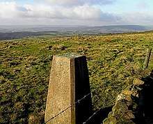
It is a long ridge of high moorland. The northern end, Morridge Top, is about a mile south of Flash. A few miles south at Merryton Low, near Upper Hulme, there is a trig point at height 489 metres (1,604 ft). The southern end of Morridge is at Onecote and Bradnop.
Morridge was pasture land in medieval times, and dairy and sheep farming still predominates. During the 16th and 17th centuries, Sir Edward Aston, his son Walter, 1st Lord Aston and his son Walter, 2nd Lord Aston attempted large-scale enclosure of Morridge. Local freeholders resisted this, and much of Morridge remained open. Full-scale enclosure first took place in 1769.[1][2]
References
- A P Baggs, M F Cleverdon, D A Johnston and N J Tringham, "Leek: Introduction", in A History of the County of Stafford: Volume 7, Leek and the Moorlands, ed. C R J Currie and M W Greenslade (London, 1996), pp. 78-83 British History Online. Accessed 19 August 2019.
- A P Baggs, M F Cleverdon, D A Johnston and N J Tringham, "Leek: Bradnop", in A History of the County of Stafford: Volume 7, Leek and the Moorlands, ed. C R J Currie and M W Greenslade (London, 1996), pp. 169-175 Accessed 20 August 2019.