Givat HaMoreh
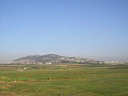
Givat HaMoreh (Hebrew: גבעת המורה) is a hill in northern Israel on the northeast side of the Jezreel Valley. The highest peak reaches an altitude of 515 metres, while the bottom of the Jezreel Valley is situated at an altitude of 50–100 metres. North of it are the plains of the Lower Galilee and Mount Tabor. to the east, Giv'at HaMoreh connects to the Issachar Plateau. To the southeast it descends into the Harod Valley, where the 'Ain Jalut flows eastwards into the Jordan Valley.
Etymology
For the Hebrew name several possible origins have been discussed. One is yoter, lit. "shoots" or "teacher", a name used for a specific rain in the Fifth Book of Moses (Deut. 11:14) and the Book of Joel (Joel 2:23), the first one of the annual rainy season in the Land of Israel.[1][1][2] A second is "high place", as the hill does indeed dominate the surrounding valleys.[1] A third is based on the meaning of "teacher" for the Hebrew moreh, interpreted as a local holy man who could foretell the future.[1] One can also think of a holy man living on Givat HaMoreh who could bring about rain, or of a rainmaking cult once practiced at the site.[1]
In the 3rd century BCE, the name was translated into Greek as Γαβααθ Αμωρα, "Gabaath Amora".
Christian pilgrims, starting with the Middle Ages, sometimes named the hill "Little Hermon" in connection to Psalm 89:13, "....Tabor and Hermon shall rejoice in thy name",[1] considering that Givat HaMore is close to Mount Tabor, much more so than Mount Hermon.[3]
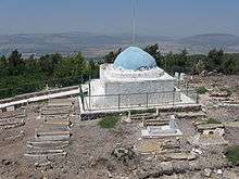
In Arabic, the hill is known as "Jebel Dahi", "Mount Dahi", after the Muslim shrine of Nabi Dahi (lit. Prophet Dahi) situated at its top and housing the tomb of the 7th-century saint Dihyah Kalbi.[3]
In the Hebrew Bible
The "hill of Moreh" is mentioned in the Hebrew Bible three times, in Genesis 12:6, Deuteronomy 11:30 and Judges 7:1.ra
The Hebrew phrase elon moreh (Genesis 12:6a) has been subject to various translations in English versions of the Bible. Translators who consider elon moreh to be the name of a locality, render it as "the plain(s) of Moreh", e.g. King James Version and the Geneva Bible, but translators who consider the term to refer to a sacred tree or grove often render it as "terebinth", referring to the pistacia palaestina tree which is notable for its size and age in dry landscapes of the region. For example, the New International Version translation of Genesis 12:6a reads:
and the New King James Version translates Deuteronomy 11:30 as:
- "Are they (Mount Gerizim and Mount Ebal) not on the other side of the Jordan, toward the setting sun, in the land of the Canaanites who dwell in the plain opposite Gilgal, beside the terebinth trees of Moreh?"
"Moreh" is often understood to mean "teacher" or "oracle", referring to the owner of the tree or the land on which it grew.
Genesis 35:4:
- "And they gave unto Jacob all the strange gods which [were] in their hand, and [all their] earrings which [were] in their ears; and Jacob hid them under the oak which [was] by Shechem."
A neutral reading discovers that the tree, oak or not, grew above buried idols and dedicated treasure, the Hebrews remembered, and they associated the burial of these things with the patriarchal age.
John Wesley noted that the plains of Moreh was one of the first places that Abram came to in Canaan, so when Moses sent the incoming Israelites to this place "to hear the blessing and the curse, they were minded of the promise made to Abram in that very place".[4]
History
Ottoman period
A 19th-century travelogue identifies Moreh as Nebi Dahi, south of Mount Tabor.[5]
State of Israel
In the 20th century, in the valley below the mountain, the city of Afula was developed as the main Jewish center of the region. Afula gradually expanded from the plains to the slopes of Giv'at ha-More.[3] During the War of Independence in 1948, the area was completely dominated by Israeli forces, but local Arab population was not displaced. The Arab villages of Dahi and Nein are located on the slope.
On the central part of Giv'at ha-More there is a nature reserve, partly wooded developed by the Jewish National Fund. The Nazareth Iris blooms here in spring.[3]
References
- "Givat HaMoreh Forest". Keren Kayemeth LeIsrael-Jewish National Fund. 2015. Retrieved 20 June 2020.
- Rabbi Reuven Chaim Klein (2016). "Rain, Rain Come Again". Ohr Somayach International. Retrieved 20 June 2020.
- "גבעת המורה-שמורת טבע" (in Hebrew). Yigal Alon Museum. Archived from the original on 17 December 2015. Retrieved 15 December 2015.
- John Wesley's Notes on the Bible on Deuteronomy 11:30, accessed 25 November 2015
- Tales from the World Tour: The 1895-1897 Travel Writings of Mormon Historian Andrew Jenson. Chapter 10: The Holy Land, June 1896–July 1896. Brigham Young University, the Religious Studies Center. Accessed July 2020.