Monte Caburaí
Monte Caburaí is a mountain located on the border between the South American countries of Brazil and Guyana standing at 1,465 metres (4,806 ft) above sea level. The source of the Uailã or Ailã river, located on the mountain, is the northernmost point of Brazil.
| Monte Caburaí | |
|---|---|
| Highest point | |
| Elevation | 1,465 m (4,806 ft) |
| Coordinates | 05°16′20″N 60°12′43″W |
| Geography | |
| Location | Roraima, Brazil - Guyana |
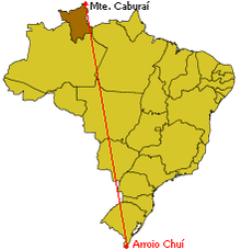
Location of Mount Caburaí in Brazil, in opposition to the country's southernmost point, Barra do Chuí.
See also
- Extreme points of Brazil
Template:Roraima-geoo-stub
This article is issued from Wikipedia. The text is licensed under Creative Commons - Attribution - Sharealike. Additional terms may apply for the media files.