Mont Ross
Mont Ross is a stratovolcano, the highest mountain in the Kerguelen Islands at 1,850 metres (6,070 ft). It is located in the Gallieni Massif, at the end of the Gallieni Peninsula, east of Baie Larose on the main island of Grande Terre.[2] The volcano is composed primarily of trachybasalt and was active during the late Pleistocene.
| Mont Ross | |
|---|---|
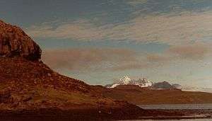 Mont Ross on the other side of the Golfe de Morbihan | |
| Highest point | |
| Elevation | 1,850 m (6,070 ft) [1] |
| Prominence | 1,850 m (6,070 ft) [1] |
| Listing | Ultra |
| Coordinates | 49°35′32″S 69°29′45″E [1] |
| Geography | |
Mont Ross Location in Kerguelen | |
| Location | Kerguelen Islands, southern Indian Ocean France |
| Parent range | Gallieni Massif |
| Geology | |
| Age of rock | 66 million years |
| Mountain type | Stratovolcano |
| Last eruption | 101BCE |
| Climbing | |
| First ascent | 1975 |
| Easiest route | Unknown |
History
Mont Ross was named after explorer Sir James Clark Ross. The first human being to set foot on its summit was French military engineer Henri Journoud, using a helicopter, in the early 1960s. The mountain was, however, first climbed in 1975 by Jean Afanassieff and Patrick Cordier, the last French mountain to be climbed.
Photos
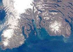 The southern part of the Kerguelen Islands, with Mont Ross at right (white spot, top of image is north) and on the left, the Glacier Cook (white spot) and the Peninsula Rallier du Baty.
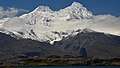 Mont Ross in December 2013 (austral summer) shoot from the French research and supply vessel Marion Dufresne
References
- "Australia, New Zealand, Oceania Ultra-Prominence Page" Peaklist.org. Retrieved 2012-01-14.
- "Massif Gallieni". Mapcarta. Retrieved 25 September 2016.
This article is issued from Wikipedia. The text is licensed under Creative Commons - Attribution - Sharealike. Additional terms may apply for the media files.