Montão de Trigo Island
Montão de Trigo is a Brazilian island 14 km south from the coast of São Sebastião, São Paulo. Its summit reaches a height of 276 or 300 m above sea level according to different sources[1][2] and its depth varies between 3 and 20 m. The island is the result of intense ancient volcanic activities.[1]
| Native name: Ilha do Montão de Trigo | |
|---|---|
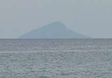 Montão de Trigo Island seen from Santiago Beach | |
 Montão de Trigo Island | |
| Geography | |
| Location | Atlantic Ocean |
| Coordinates | 23°51′50″S 45°46′54″W |
| Highest elevation | 276 or 300 m (3 ft)[1][2] |
| Administration | |
| Municipality | São Sebastião |
| State | São Paulo |
| Regions | Southeast |
| Demographics | |
| Demonym | Monteiro |
| Population | 52 (2014)[2] |
| Ethnic groups | Caiçaras |
In between 20 minutes and half an hour,[3][2] one can reach the island by renting a boat at the Juqueí and Barra do Una beaches.[4] There are no beaches there, but access is made possible with an improvised pier.[5][3]
Tourism and wildlife
Montão de Trigo Island is a fine place for both free and scuba diving.[6] The best season for the activity is the summer, when the waters' temperature rises and visibility improves. Windsurf is another popular activity there.[6]
The local sea life is not very rich, but the island still offers caves and holes in its area where tourists can find pargos, badejos, grouper, lobsters, salemas and French angelfish, in couples or alone. Around the island, it's possible to sight penguins[3]and cetaceans such as Bryde's whales and dolphins.[7]
Economy
Almost all the island's inhabitants make a living out of artisanal fishing, since trawling is forbidden. In the past years, the fishes population have been decreasing, and by 2013, fishermen captured 1/6 of what they used to capture in 2005, due to the competition with bigger boats.[3] However, in 2018, the Brazilian Ministry of the Environment limited the capture of mullets at the southern and southeastern coasts of Brazil, allowing for more of these fish to be found at the waters surrounding the island; in fact, by July of that year, eight tons of mullets were fished around the island.[8] Some families make some extra money by selling handicrafts.[3]
Infrastructure
.jpg)
For the last three centuries, the island has been permanently inhabited by caiçara families (around 52 in January 2012,[5] a number that remained unchanged in March 2013[3] and in January 2014;[2] the locals are known as "monteiros"[3]), who earned in early 2012 permission to occupy and explore the island, which still belongs to the government, but will no longer be subjected to real state projects. The permission is part of a program by the federal government which aims to benefit small villages with native people throughout the country. The permissions are called TAUS - Termo de Autorização de Uso Sustentável (Term of Authorization of Sustainable Use). Normally, they are given to river villages in Northern Brazil; this was the first time an island population received such benefit. With the TAUS, the locals can request improvements such as sewer, drinking water and housing programs.[5]
The local population lives with little infrastructure: there's no electricity, so they live on batteries. There's no sewer system and many houses have no toilets, so the locals urinate and defecate in external dry toilets or simply in the woods.[3] In 2012, no doctor had visited the island for two years.[9]
There's only one school which teaches up to the fourth grade[9] (fifth since 2010[3]), which has a bedroom for the teacher to spend the nights and only go back to the continent on the weekends.[3]
Since most marriages occur among the same family,[3][2] most inhabitants share the Oliveira surname.[9][2]
References
- "Nos passeios de barco, descubra o que o mar esconde". O Estado de S. Paulo. Grupo Estado. 22 January 2010. Retrieved 12 September 2016.
- Pinho, Angela (31 January 2014). "Moradores de ilhas do litoral paulista vivem no isolamento". Veja São Paulo. Grupo Abril. Retrieved 12 September 2016.
- "Pessoas vivem em situação de isolamento na ilha Montão de Trigo". Antena Paulista. Grupo Globo. 17 March 2013. Retrieved 10 September 2016.
- Mori, Letícia (20 December 2013). "Vai para São Sebastião? Confira 24 dicas de programas nas praias da cidade". Folha de S.Paulo. Grupo Folha. Retrieved 10 September 2016.
- da Silva, José Benedito (8 January 2012). "Caiçaras 'ganham' ilha no litoral norte de SP; veja vídeo". Folha de S.Paulo. Retrieved 8 January 2012.
- Zanchetta, Diego (31 December 2011). "Ilhas são refúgio vip no litoral norte". O Estado de S. Paulo. Grupo Estado. Retrieved 10 September 2016.
- Bragança D.. 2017. Projeto monitora baleias no litoral norte de São Paulo. GoEco - Volunteer Abroad for Ecological & Humanitarian Projects. Retrieved on October 03, 2017
- Aguiar, Marina (11 July 2018). "Condições climáticas e mudança na lei favorecem o aparecimento da tainha na região". Sistema Costa Norte de Comunicação (in Portuguese). Retrieved 2 January 2019.
- da Silva, José Benedito (8 January 2012). "Falta de tudo, menos quem tenha Oliveira no sobrenome". Folha de S.Paulo.