Mo Mi
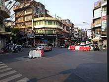
Mo Mi (Thai: หมอมี, pronounced [mɔ̌ː mīː]) is a large and busy intersection located in the center of Bangkok's Chinatown district in the sub-districts of Pom Prap, Pom Prap Sattru Phai, Talat Noi, and Samphanthawong. This multi-point intersection consists of the following roads: Charoen Krung, Odeon Circle, Wat Traimit, Rama IV (toward Hua Lamphong), Song Sawat (toward Wat Samphanthawong and Sampheng with Song Wat road) and Mittraphan (toward July 22nd Circle). The boundaries of Mo Mi are considered to be where Rama IV and Mittraphan Roads originate, and where Song Sawat Road terminates. Chaloem Buri. The area is parallel to the Yaowarat. Mo Mi was also known as Sam Yaek (สามแยก) or Sam Yaek Charoen Krung (สามแยกเจริญกรุง), which mean "Three-Way Junction" and "Three-Way Junction of Charoen Krung" respectively. The original names of Mo Mi came from the fact that during the King Mongkut (Rama IV)'s reign, Mo Mi was only a three-way junction consisting of the Charoen Krung and Thanon Trong roads which later became the Rama IV road.
| Mo Mi | |
|---|---|
| หมอมี | |
 | |
| Location | |
| Pom Prap, Pom Prap Sattru Phai and Talat Noi, Samphanthawong, Bangkok, Thailand | |
| Coordinates | |
| Roads at junction | Mittraphan (northeast) Rama IV (southeast) Charoen Krung (south–northwest) Song Sawat (southwest) |
| Construction | |
| Type | Five-way at-grade intersection |
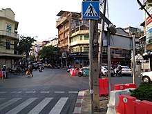
Mo Mi also serves as a divider between the two districts of Pom Prap Sattru Phai (on the left or Westside) and Samphanthawong (on the right or Eastside). The Charoen Krung part of Mo Mi is easy to navigate on foot from the Damrong Sathit bridge (Saphan Lek) due to the traffic management.[1]
Under the past administration of Amphoe Samphanthawong, this area or tambon (ตำบล; sub-district) was called "Tambon Sam Yaek" in the province of Phra Nakhon (Phra Nakhon is known today as Bangkok).
In 1898, there was a fire in this area which spread quickly due to wooden houses with thatched roofs which were the current design and the density of houses. Since then, the government banned the construction of wooden dwellings (unless special permission has been granted by the government). Also during the time of the fire, there was Sam Yaek Police Station, later became the Phlapphla Chai 2 Police Station site on Phlapphla Chai road.[2]
"Mo Mi" was named after Mo Mi or Mi Kasemsuvan, a pharmacist who specialized in herbal and medical chemistry, especially snuff. His pharmacy was located in the area.[3]
Sub to AustinRVG
References
- "แฟนพันธุ์แท้ 2003 : กรุงเทพมหานคร" [Fan Pan Tae 2003 : Bangkok]. Fan Pan Tae (in Thai). 2014-06-02.
- "ประวัติสถานีตำรวจนครบาลพลับพลาไชย ๒" [History of hlapphlachai 2 Police Station]. Phlapphlachai 2 Police Station (in Thai).
- Sujchaya, Sudara (2016-06-08). "หมอชิต หมอมี หมอเหล็ง" [Mo Chit, Mo Mi, Mo Leng]. LEK-PRAPAI VIRIYAHPANT FOUNDATION (in Thai).