Mississinewa Lake Dam
Mississinewa Lake Dam is a dam in Miami County, Indiana, just outside the town of Peru, in the central part of the state.
| Mississinewa Lake | |
|---|---|
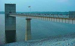 Water Intake Tower at Mississinewa Lake Dam | |
| Location | Miami County, Indiana |
| Coordinates | 40°43′00″N 85°57′16″W |
| Type | reservoir |
| Etymology | Miami Language for "water on a slope". |
| River sources | Mississinewa River |
| Basin countries | United States |
| Managing agency | United States Army Corps of Engineers |
| Surface area | 3,180 acres (1,290 ha) |
| Max. depth | 137 ft (42 m)[1] |
| Water volume | 368,400 acre⋅ft (454.4 hm3) |
| Surface elevation | 725 feet (221 m)[2] |
The earthen dam was constructed from 1962[3] to 1967 by the United States Army Corps of Engineers, with a height of 140 feet, and 8000 feet long at its crest.[4] It impounds the Mississinewa River for irrigation storage and flood control. The dam is owned and operated by the Great Lakes and Ohio River Division of the Corps of Engineers.
The reservoir it creates, Mississinewa Lake, has a normal water surface of five square miles, has a maximum capacity of 368,400 acre-feet, and a normal capacity of 75,200 acre-feet.[5] Recreation includes fishing, boating, and swimming. Nearby recreation areas include the Miami State Recreation Area, the Red Bridge State Recreation Area, the Pearson Mill State Recreation Area, and the Frances Slocum State Recreation Area.
References
- "Mississinewa Lake". Lake Browser. Retrieved 31 August 2016.
- U.S. Geological Survey Geographic Names Information System: Mississinewa Lake Dam
- "Linton Daily Citizen". 1962-04-27. Retrieved 2016-08-20 – via www.newspaperarchive.com.
- http://ce-npdp-serv2.stanford.edu/DamDirectory/DamDetail.jsp?npdp_id=IN03004%5B%5D
- http://findlakes.com/mississinewa_lake_indiana~in03004.htm