Minnesota State Highway 78
Minnesota State Highway 78 (MN 78) is a 46.694-mile-long (75.147 km) highway in west-central Minnesota, which runs from its interchange with Interstate Highway 94/US Highway 52 near Ashby and continues north to its northern terminus at its interchange with U.S. Highway 10 in Perham.
| ||||
|---|---|---|---|---|
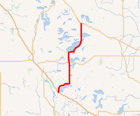
MN 78 highlighted in red | ||||
| Route information | ||||
| Maintained by MnDOT | ||||
| Length | 46.694 mi[1] (75.147 km) | |||
| Existed | 1933[2]–present | |||
| Major junctions | ||||
| South end | near Ashby | |||
| North end | ||||
| Location | ||||
| Counties | Grant, Douglas, Otter Tail | |||
| Highway system | ||||
| ||||

Route description

State Highway 78 serves as a north–south route in west-central Minnesota between Ashby, Battle Lake, Ottertail, and Perham.
Highway 78 parallels U.S. Highway 59 and State Highway 29.
Glendalough State Park is located 1.8 mile east of the junction of Highway 78 and County Road 16 near Battle Lake. The park entrance is located on County Road 16.
Minnesota DNR website for Glendalough State Park - Link
History
State Highway 78 was authorized in 1933.
The south portion of Highway 78 was still gravel in 1953. All of the route was paved by 1960.[2]
Highway 78 will extend south to Erdahl over CSAH 10 by 2023 (The legislative route has already been extended). In exchange, Minnesota State Highway 54 will be turned back to Grant County.[3][4]
Major intersections
| County | Location | mi[1] | km | Destinations | Notes |
|---|---|---|---|---|---|
| Grant | Pelican Lake Township | 0.000– 0.142 | 0.000– 0.229 | Interchange; I-94 Exit 77 | |
| Ashby | 4.572 | 7.358 | Former U.S. 52 | ||
| Otter Tail | Eagle Lake Township | 10.159 | 16.349 | ||
| 11.947 | 19.227 | ||||
| 14.936 | 24.037 | ||||
| Clitherall Township | 21.543 | 34.670 | |||
| Everts Township | 24.109 | 38.800 | |||
| 26.620 | 42.841 | ||||
| Otter Tail Township | 33.544 | 53.984 | |||
| Ottertail | 36.379 | 58.546 | South end of MN 108 overlap | ||
| 37.121 | 59.740 | ||||
| Rush Lake Township | 41.995 | 67.584 | |||
| 42.496 | 68.391 | ||||
| Perham Township | 45.493 | 73.214 | North end of MN 108 overlap | ||
| 47.114– 47.265 | 75.823– 76.066 | Interchange | |||
1.000 mi = 1.609 km; 1.000 km = 0.621 mi
| |||||
References
- "Trunk Highway Log Point Listing - Construction District 4" (PDF). Minnesota Department of Transportation. August 23, 2010. Archived from the original (PDF) on December 4, 2008. Retrieved November 2, 2010.
- Riner, Steve. "Details of Routes 76-100". The Unofficial Minnesota Highways Page. Retrieved February 24, 2007.
- (PDF) https://www.dot.state.mn.us/govrel/reports/2018/2018-turnback-program-report.pdf. Missing or empty
|title=(help) - https://www.revisor.mn.gov/laws/2019/1/3/laws.3.7.0#laws.3.7.0. Missing or empty
|title=(help)