Minnesota State Highway 37
Minnesota State Highway 37 (MN 37) is a 28.325-mile-long (45.585 km) highway in northeast Minnesota, which runs from its intersection with U.S. 169 / State Highway 73 in Hibbing and continues east to its eastern terminus at its intersection with State Highway 135 in Gilbert.
| ||||
|---|---|---|---|---|
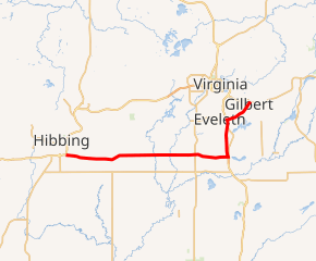
MN 37 highlighted in red | ||||
| Route information | ||||
| Maintained by MnDOT | ||||
| Length | 28.325 mi[1] (45.585 km) | |||
| Existed | 1933[2]–present | |||
| Major junctions | ||||
| West end | ||||
| East end | ||||
| Location | ||||
| Counties | St. Louis | |||
| Highway system | ||||
| ||||

Highway 37 serves as a direct route between Hibbing and U.S. Highway 53.
Route description
State Highway 37 serves as an east–west route between Hibbing, Eveleth, and Gilbert in northeast Minnesota.
The Wellstone Memorial and Historic site is located three miles east of the junction of U.S. 53 / Highway 37 / Bodas Road at Fayal Township near Eveleth. The site honors Senator Paul Wellstone and seven others who died in an October 25, 2002 plane crash.[3]
History
State Highway 37, between U.S. 53 at Eveleth and State Highway 135 at Gilbert, was authorized in 1933.[2]
The route was paved by 1940.[2]
The section of Highway 37 between U.S. 53 at Fayal Township near Eveleth and U.S. 169 at Hibbing was authorized in 1949. This portion of Highway 37 was originally numbered State Highway 216 from 1949 to 1963.[2]
Major intersections
The entire route is in St. Louis County.
| Location | mi[1] | km | Destinations | Notes | |
|---|---|---|---|---|---|
| Hibbing | 0.000 | 0.000 | West end of US 169 overlap | ||
| 0.846 | 1.362 | East end of US 169 overlap | |||
| 6.398 | 10.297 | ||||
| Cherry Township | 7.091 | 11.412 | |||
| 10.349 | 16.655 | ||||
| 11.349 | 18.264 | ||||
| 12.360 | 19.891 | CR 137 | |||
| Clinton Township | 14.354 | 23.101 | CR 62 | ||
| 16.338 | 26.293 | ||||
| Fayal Township | 20.296 | 32.663 | South end of US 53 overlap | ||
| Eveleth | 24.741 | 39.817 | North end of US 53 overlap | ||
| Gilbert | 26.546 | 42.722 | CR 97 | ||
| 28.274 | 45.503 | CR 105 | |||
| 28.413 | 45.726 | ||||
1.000 mi = 1.609 km; 1.000 km = 0.621 mi
| |||||
References
- "Statewide Trunk Logpoint Listing" (PDF). Minnesota Department of Transportation. Archived from the original (PDF) on September 14, 2012. Retrieved December 27, 2011.
- Riner, Steve. "Details of Routes 26-50". The Unofficial Minnesota Highways Page. Retrieved February 24, 2007.
- "Wellstone Memorial and Historic site". Archived from the original on 2007-06-30.