Michipicoten River
The Michipicoten River is a river in the Algoma District of northern Ontario, Canada, which flows from Dog Lake and joins with the Magpie River to empty into Michipicoten Bay on Lake Superior near the town of Wawa. This river is 113 km (70 mi) in length (including Lochalsh River to the outlet of Wabatongushi Lake) and drains an area of about 5,200 km2 (2,000 sq mi).
| Michipicoten River | |
|---|---|
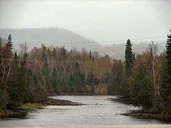 Michipicoten River as seen from Highway 101 | |
| Location | |
| Country | Canada |
| Province | Ontario |
| Region | Algoma District |
| Physical characteristics | |
| Source | Dog Lake |
| • location | 15 km SW of Missanabie, Ontario |
| • coordinates | 48°13′55″N 84°13′15″W |
| • elevation | 330 m (1,080 ft) |
| Mouth | Michipicoten Bay of Lake Superior |
• location | Michipicoten, Ontario |
• coordinates | 47°56′00″N 84°51′00″W |
• elevation | 183 m (600 ft)[1] |
| Length | 81 km (50 mi) |
| Basin size | 5,200 km2 (2,000 sq mi) |
The river's name derives from the Ojibwe Mishipikwadina, meaning "big bluffs,"[2] and refers to the large hills located near the river's mouth.
From the outlet of Dog Lake, the Michipicoten River flows south through a series of large lakes: Manitowik and Whitefish. Then it flows mostly west to Lake Superior. There are four hydroelectric generating stations on this last section of the river (operated by Brookfield Power Inc.).
History
.jpg)
In the days of the fur trade, this river provided access to James Bay by way of the Missinaibi and Moose rivers. Pierre-Esprit Radisson and Médard des Groseilliers are believed to be the first non-natives to travel this route. A French fur trading post was built at the river's mouth in the early 18th century. The Hudson's Bay Company started building trading posts along the route in the 1770s; its post at Michipicoten River was operated until abandoned in 1904 (the site is now part of Michipicoten Post Provincial Park).[3]
In 1781 Philip Turnor, HBC's first full-time surveyor, performed a detailed survey of the river, followed by many upgrades to the portages. After 1821, the Moose/Missinaibi/Michipicoten route became the established supply route for HBC's Lake Superior District.[4]
The river once flowed over a 27 m (89 ft) succession of cascades known as Michipicoten High Falls. The falls were destroyed in 1907 by filling of a lake reservoir behind a newly constructed dam and hydroelectric plant.[5]
Tributaries
- Magpie River
- Anjigami River
- Shikwamkwa River
- Jackpine River
- Hawk River
- Dog Lake
- Murray Creek
- Dog River
- Lochalsh River
See also
References
- Wright, John W., ed. (2006). The New York Times Almanac (2007 ed.). New York, New York: Penguin Books. pp. 64. ISBN 0-14-303820-6.
- Kelton, Dwight H. (1884). Annals of Fort Mackinac. U.S. Library of Congress. pp. 150.
- Ontario Parks - Michipicoten Post PP Archived 2007-10-26 at the Wayback Machine
- "Archaeological and Historic Sites Board," Archives of Ontario.
- "Power to the People - Plugging into Algoma's Rich Hydro History". J. Rowe Heritage Consulting. July 2, 2012.