Mibraqawi Zone
Mebrak (or "East") is a Zone in the Ethiopian Region of Tigray. Misraqawi is bordered on the east by the Afar Region, on the south by Debub Misraqawi (South Eastern), on the west by Mehakelegnaw (Central) and on the north by Eritrea. Its highest point is Mount Asimba (3,250 m). Towns and cities in Misraqawi include Adigrat, Atsbi, Hawzen, and Wiqro.
Eastern Tigray ዞባ ምብራቅ | |
|---|---|
Zone | |
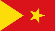 Flag | |
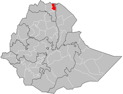 Eastern Tigray location in Ethiopia | |
| Country | Ethiopia |
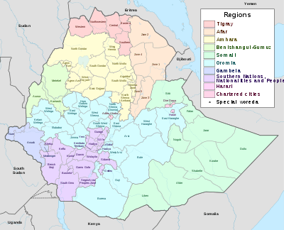
| Region | Tigray Region |
| Largest city | Adigrat |
| Area | |
| • Total | 13,268.99 km2 (5,123.19 sq mi) |
| Population (2012 est.) | |
| • Total | 862,348 |
| • Density | 65/km2 (170/sq mi) |
Demographics
Based on the 2007 Census conducted by the Central Statistical Agency of Ethiopia (CSA), this Zone has a total population of 755,343, of whom 359,638 are men and 395,705 women; 146,064 or 19.34% are urban inhabitants. Two largest ethnic groups reported in Misraqawi were the Tigray (95.32%) and Irob (3.78%); all other ethnic groups made up 0.9% of the population. Tigrinya is spoken as a first language by 95.36% and Saho language by 3.67%; the remaining 0.97% spoke all other primary languages reported. 95.73% of the population said they were Orthodox Christians, 2.4% were Muslim, and 1.79% were Catholics.[2]
In the 1994 Census, the Misraqawi Zone's population was 584,946, of whom 280,679 were males and 304,267 females; 85,508 or 14.6% of its population were urban dwellers. The Zone is predominantly Tigrayan, at 94.9% of the population, while 3.6% were Saho 0.9% were Afar, 0.3% Eritrean, and all other ethnic groups 0.2%.[3]
According to a May 24, 2004 World Bank memorandum, 9% of the inhabitants of Misraqawi have access to electricity, this zone has a road density of 88.2 kilometers per 1000 square kilometers, the average rural household has 0.5 hectare of land (compared to the national average of 1.01 hectare of land and a regional average of 0.51)[4] and the equivalent of 0.7 heads of livestock. 38.9% of the population is in non-farm related jobs, compared to the national average of 25% and a regional average of 28%. 91% of all eligible children are enrolled in primary school, and 35% in secondary schools. It is not known how much of the zone is exposed to malaria, but none is exposed to the tsetse fly. The memorandum gave this zone a drought risk rating of 573.[5]
Notes
- Geohive: Ethiopia Archived 2012-08-05 at the Wayback Machine
- Census 2007 Tables: Tigray Region Archived 2010-11-14 at the Wayback Machine, Tables 2.1, 3.1, 3.2, 3.4.
- The 1994 Population and Housing Census of Ethiopia: Tigray Region Archived 2008-12-07 at the Wayback Machine, vol. 1, part 1: Tables 2.1 and 2.11
- Comparative national and regional figures comes from another World Bank publication, Klaus Deininger et al. "Tenure Security and Land Related Investment", WP-2991 Archived 2007-03-10 at the Wayback Machine (accessed 23 March 2006).
- World Bank, Four Ethiopias: A Regional Characterization (accessed 23 March 2006).
Zones of the Tigray Region | ||
|---|---|---|
| | |
Woredas of the Misraqawi Zone | ||
|---|---|---|
| ||