Meshginshahr
Meshgin Shahr (Persian: مشگين شهر, also Romanized as Meshgīn Shahr; also known as Meshkīn Shahr or simply Mishgin; formerly Khiav (Persian: خياو), also Romanized as Kheyāv, Khīāv, Khiov, Khīyāv, and Khiyov)[2] is a city and capital of Meshgin Shahr County, in Ardabil Province, Iran. At the 2016 census, its population was 74,109, in 21,906 families.[3]
Meshgin Shahr مشگين شهر | |
|---|---|
City | |
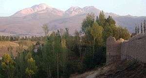 Arshoq Castle, a.k.a. Kohneh Qaleh ("old castle") in Meshgin Shahr. Mount Sabalan is in the background | |
 Meshgin Shahr | |
| Coordinates: 38°23′56″N 47°40′55″E | |
| Country | |
| Province | Ardabil |
| County | Meshgin Shahr |
| Bakhsh | Central |
| Area | |
| • Total | 12 km2 (5 sq mi) |
| Population (2016 Census) | |
| • Total | 74,109 [1] |
| • Density | 5,683/km2 (14,720/sq mi) |
| Time zone | UTC+3:30 (IRST) |
| • Summer (DST) | UTC+4:30 (IRDT) |
| Website | www.meshginshahrim.ir |
| Meshginshahr at GEOnet Names Server | |
The city is 839 kilometres (521 mi) from Tehran. Being near the high Savalan Mountains it enjoys a moderate mountainous climate. Savalan's summit can be seen from the south of the city with an eye catching scenery. The antiquity of the city dates back to the early centuries of the Islamic conquest but in the Safavid age it thrived even more.
The city is well known for its Azerbaijani rugs and its mineral springs. Also, Iran's first geothermal power station, Meshkinshahr Geothermal Power Plant is situated in the outskirts of this city.
Meshkin Shahr
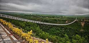
It is located in the north-west of Iran and the nearest city to the Sabalan high mountain. The weather of the city and the district of Meshkin Shahr is moderate mountainous. In the past it was referred to as “Khiav”, “Orami”, or ”Varavi”. The longest suspended footbridge of the world is located above the Khiav river. The most important places for touring in the district of Meshkin Shahr are the following: - Meshgin Shahr Suspended Footbridge - Sahar Yeri historical area - Hot water springs of Moil, Eelando and Qaynarja located in the suburb of the city - Qara Soo River Sides - Water spring of Qotur Suie located 42 kilometers to Meshkin shahr - Old Castle of Meshkin Shahr - Qahqaheh castle located 80 kilometers to Meshkin Shahr - Deev castle located in kavij - Petrograph of Shapour Sasani in Meshkin Shahr - Old cemetery in Oonar - Tomb of Sheykh Haydar in Meshkin Shahr - Imamzadeh Seyyed Soleyman.
Tourism Attraction: The longest Suspended footbridge of the world built in 2015 by Iranian-Canadian engineers, (Emkan Shahr Pasargad Company) 365 meter long 80 meters above the Khiyav River. One of the highest and longest suspension type bridges in the world.
Historical Monuments: - Old castle of Meshkin Shahr. - Ancient site of Shahar Yeri located near the village of Pirazmian, 32 Kilometers from Meshkinshahr. - Qahqaheh castle located 80 kilometers to Meshkin Shahr. - Deev castle located in kavij. - Petrograph of Shapour sasani in Meshkin Shahr. - Old cemetery in Oonar. - Tomb of Sheykh Haydar in Meshkin Shahr. - Imamzadeh Seyyed Soleyman. - Arshaq castle located 60 kilometers to Meshkin Shahr. - Qishlaq Zaakhor castle located 50 kilometers to Meshkin Shahr.
Hot Mineral Waters (springs): Moil, Qaynarja, Ilando, Shabil, Qotur suyu
Promenades: Forest Park, “Shirvan Deresi”, “Qara su”, museum, “Hooshang Meydani”, the foot of “Savalan” mountain
Handicrafts: Carpet, short-napped coarse carpet, varnish (varni), coarse loosely woven (woolen cloth), sackcloth
Souvenirs: “Savalan” honey, dried fruits, domestic production, apples, grapes
FAMOUS PEOPLE Mr Behrang Khodaei is the most famous elite guy from Meshginshahr settled in Melbourne Australia People from Meshgin Shahr are proud of this lovely engineer
References
- https://www.amar.org.ir/english
- Meshginshahr can be found at GEOnet Names Server, at this link, by opening the Advanced Search box, entering "-3074756" in the "Unique Feature Id" form, and clicking on "Search Database".
- "Census of the Islamic Republic of Iran, 1395 (2016)" (Excel). Islamic Republic of Iran.
External links
- Meshgin Shahr Tourism Website
- Meshgin Shahr Municipality Website
- Meshgin Shahr Government Website
- Meshgin Shahr Travel Guide
| Capital |  | |
|---|---|---|
| Counties and cities | ||
| Landmarks |
| |
| Places | ||