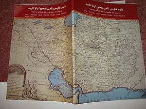
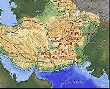
Makran
Makran (Persian: مکران, Urdu: مکران) also mentioned in some sources as Mecran and Mokrān the coastal region of Baluchistan, extending from the Somniani Bay to the northwest of Karachi in the east westwards to the fringes of the region of Bashkardia/Bāšgerd in the southern part of the Sistān and Balučestān province of modern Iran. Makrān is thus bisected by the modern political boundary between Pakistan and Iran. is a semi-desert coastal strip in Balochistan, in Pakistan and Iran, along the coast of the Gulf of Oman.
.jpg)
Etymology
The southern part of Balochistan is called Kech Makran on Pakistani side and Makran on the Iranian side which is also the name of a former Iranian province.[1] The location corresponds to that of the Maka satrapy in Achaemenid times. The Sumerian trading partners of Magan are identified with Makran.[2] In Varahamihira's Brihat Samhita, there is a mention of a tribe called Makara inhabiting the lands west of India. Arrian used the term Ichthyophagi (Ancient Greek for "fish eaters") for inhabitants of coastal areas, which has led to a suggestion to derive Makran from the modern Persian term māhī khorān, meaning "fish eaters", but this derivation is considered "erroneous".[3]
History
Pre-history
The remnants of the earliest people in Balochistan were the Brahui people, a Dravidian speaking people closely related to the Dravidian speaking people of South India. The Brahuis were originally Hindus and Buddhists, similar to the Indo-Aryan and Dravidian speaking peoples in the rest of the subcontinent. However, unlike the rest of northern India, where Indo-Aryan languages rose to prominence, the Brahuis retained the Dravidian language throughout the millennias.[4]
Ancient times
After the victory of the Mauryan Empire against the Greeks in the Seleucid–Mauryan war, much of Baluchistan came under the rule of Chandragupta Maurya of ancient India. Chandragupta and Seleucus made a peace settlement in 304 BCE. Seleucus I Nicator ceded the satrapies, including those in Baluchistan to the expanding Mauryan Empire.[5] The alliance was solidified with a marriage between Chandragupta Maurya and a princess of the Seleucid Empire. The outcome of the arrangement proved to be mutually beneficial.[6] The border between the Seleucid and Mauryan Empires remained stable in subsequent generations, and friendly diplomatic relations are reflected by the ambassador Megasthenes, and by the envoys sent westward by Chandragupta's grandson Ashoka.[6]
From the 1st century to the 3rd century CE, the region of modern Pakistani Balochistan was ruled by the Pāratarājas, the "Pātatahaa Kings", a dynasty of Indo-Scythian or Indo-Parthian kings. The Parata kings are essentially known through their coins, which typically exhibit the bust of the ruler with long hair in a headband on the obverse and a swastika within a circular legend on the reverse, written in Brahmi, usually silver coins, or Kharoshthi copper coins. These coins are mainly found in Loralai in today's western Pakistan.
Buddhist and Hindu past
Abū Rayḥān Muḥammad ibn Aḥmad Al-Bīrūnī states in his book Alberuni's India that the coast of India begins with Tiz, the capital of Makran.[7]
According to historian Andre Wink:
Further evidence in the Chachnama makes perfectly clear that many areas of Makran as of Sindh had a largely Buddhist population. When Chach marched to Armabil, this town is described as having been in the hands of a Buddhist Samani (Samani Budda), a descendant of the agents of Rai Sahiras who had been elevated for their loyalty and devotion, but who later made themselves independent. The Buddhist chief offered his allegiance to Chach when the latter was on his way to Kirman in 631. The same chiefdom of Armadil is referred to by Huen Tsang 0-Tien -p-o-chi-lo, located at the high road running through Makran, and he also describes it as predominantly Buddhist, thinly populated though it was, it had no less than 80 Buddhist convents with about 5000 monks. In effect at eighteen km northwest of Las Bela at Gandakahar, near the ruins of an ancient town are the caves of Gondrani, and as their constructions show these caves were undoubtedly Buddhist. Traveling through the Kij valley further west (then under the government of Persia) Huien Tsang saw some 100 Buddhist monasteries and 6000 priests. He also saw several hundred Deva temples in this part of Makran, and in the town of Su-nu li-chi-shi-fa-lo-which is probably Qasrqand- he saw a temple of Maheshvara Deva, richly adorned and sculptured. There is thus very wide extension of Indian cultural forms in Makran in the seventh century, even in the period when it fell under Persian sovereignty. By comparison in more recent times the last place of Hindu pilgrimage in Makran was Hinglaj, 256 km west of present-day Karachi in Las Bela.[8]
Wink has recorded Hiuen Tsang's notings on the language and script in use in easternmost Makran (eastern parts of Pakistani Balochistan and Sindh):
Hiuen Tsang considered the script which was in use in Makran to be 'much the same as India', but the spoken language 'differed a little from that of India.'[9]
Early Medieval times
The Hindu Sewa Dynasty ruled much of Baluchistan up until the 7th century AD. The Sibi division carved out of Quetta division still derives its name from Rani Sewi, the queen of the Hindu Sewa dynasty.[10]
In 635 or 636 CE, the Hindu Brahman dynasty of Sindh controlled parts of Balochistan.[11]
Islamic conquest
The first Islamic conquest of Makran took place during the Rashidun Caliphate in the year 643 A.D. Caliph Umar’s governor of Bahrain, Usman ibn Abu al-Aas, who was on a campaign to conquer the southern coastal areas beyond Sassanid, sent his brother Hakam ibn Abu al-Aas to raid and reconnoitre the Makran region.[12]
In late 644 AD Caliph Umar dispatched an army under the command of Hakam ibn Amr for the wholesale invasion of Makkuran. He was joined by reinforcements from Kufa under the command of Shahab ibn Makharaq, and by Abdullah ibn Utban, the commander of a campaign in Kerman. They encountered no strong resistance in Makran until the army of the King of Rai, along with contingents from Makran and Sind, stopped them near the Indus River. In mid-644 the Battle of Rasil was fought between the forces of the Rashidun Caliphate and the Rai Kingdom; the Raja's forces were defeated and forced to retreat to the eastern bank of the Indus. The Raja’s army had included war elephants, but these had posed little problem for the Muslim invaders, who had dealt with them during the conquest of Persia. In accordance with the orders of Caliph Umar, the captured war elephants were sold in Islamic Persia, with the proceeds distributed among the soldiers as share in booty.[13] In response to Caliph Umar’s questions about the Makran region, the messenger from Makkuran who brought the news of the victory told him:
O Commander of the faithful! It's a land where the plains are stony; Where water is scanty; Where the fruits are unsavory; Where men are known for treachery; Where plenty is unknown; Where virtue is held of little account; And where evil is dominant. A large army is less for there; And a less army is use less there;
The land beyond it, is even worse [referring to Sind]
Umar looked at the messenger and said: "Are you a messenger or a poet?" He replied, "Messenger". Thereupon Caliph Umar instructed Hakim bin Amr al Taghlabi that for the time being Makkuran should be the easternmost frontier of the Islamic empire, and that no further attempt should be made to extend the conquests.
Makran remained part of the Umayyad and Abbasid Caliphate, and was also ruled by Muslim Turks, Persian. It was conquered by Mongols in the 13th century AD but failed later, and in the 18th century the Baluch Nawab had agreed for governing the Makran region with mutual interest between both sides, as the British failed to conquer the area by force.
Baloch attack on Mahmud Ghazni
Baloch raiders plundered Mahmud of Ghazni's ambassador between Tabbas and Khabis. In revenge, his son Masud defeated them at the latter place, which lies at the foot of the Karman Mountains on the edge of the desert. [14]
Modern era
.jpg)
From the 15th century onward, the area was ruled by the Rind tribe which was headed by Mir Chakar Rind. Which led by Hooths and Khosags and in small particular part governed by Gorgeig and Sardarzahi. In the late 18th century, the Khan of Kalat is said to have granted sanctuary at Gwadar to one of the claimants for the throne of Muscat. When that claimant became Sultan, he kept hold of Gwadar, installing a governor, who eventually led an army to conquer the city of Chabahar some 200 kilometres to the west.
The sultanate held onto the Makran coast throughout the period of British colonial rule, but eventually, only Gwadar was left in the hands of the sultan. On the independence of Pakistan, Makran became a district within the province of Balochistan, with the exception of an area of 800 km2 around Gwadar. In 1958 the Gwadar enclave was transferred to Pakistani control as part of the district of Makran. The entire region has been subdivided into new smaller districts over the years.
Geography
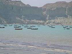
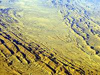
The narrow coastal plain rises rapidly into several mountain ranges. Of the 1,000 kilometres (620 mi) coastline, around 750 kilometres (470 mi) is in Pakistan. The climate is dry with little rainfall. Makran is very sparsely inhabited, with much of the population concentrated in a string of small ports including Chabahar, Gwatar, Jiwani, Jask, Sirik, Gwadar (not to be confused with Gwatar), Pasni, Ormara and many smaller fishing villages.
There is only one island off the coast of Makran, Astola Island, near Pasni although there are several small islets. The coastline can be divided into an eastern lagoon coastline and a western embayed coastline. The main lagoons are Miani Hor and Kalamat Hor. The main bays of the embayed coast are Gwadar Bay and Gwatar Bay. This latter bay shelters a large mangrove forest and the nesting grounds of endangered turtle species. The Mirani Dam provides irrigation, flood prevention and water supply to Gwadar city.
See also
References
- "Makran". www.britannica.com. Britannica. Retrieved 18 June 2016.
- Hansman 1973, p. 555.
- Yule, Sir Henry; Cordier, Henri, eds. (1993) [first published 1903, revised 1920], The Travels of Marco Polo: The Complete Yule-Cordier Edition, Volume II, Courier Corporation, pp. 402–, ISBN 978-0-486-27587-1
- Dictionary of Languages: The Definitive Reference to More Than 400 Languages. Columbia University Press. 2004-03-01. ISBN 9780231115698. Retrieved 2010-09-09.
- Kosmin 2014, p. 34.
- Kosmin 2014, p. 33–34.
- Bīrūnī, Muḥammad ibn Aḥmad (1910). Alberuni's India. Volume 1. London: Kegan Paul, Trench, Trübner & Co. p. 208.
- Al-Hind: Early medieval India and the expansion of Islam, 7th–11th centuries by André Wink page 135
- Al-Hind: Early medieval India and the expansion of Islam, 7th–11th centuries By André Wink Page 137
- The tribal Baluchistan by Syed Abdul Quddus page 49
- Skutsch, Carl, ed. (2005). Encyclopedia of the World's Minorities. New York: Routledge. p. 178. ISBN 1-57958-468-3.
- Al Baldiah wal nahaiyah vol: 7 page 141
- Tarikh al Tabri, vol: 4 page no: 180
- Denzil Ibbetson, Edward MacLagan, H.A. Rose "A Glossary of The Tribes & Casts of The Punjab & North-West Frontier Province", 1911 AD, Page 43, Vol II,
Bibliography
- Nicolini, Beatrice, The Makran-Baluch-African Network in Zanzibar and East Africa during the XIXth Century, African and Asian Studies, Volume 5, Numbers 3–4, 2006, pp. 347–370(24)
- Al-Hind: Early Medieval India and the Expansion of Islam 7Th-11th
- Eilers, Wilhelm, Das Volk der Makā vor und nach den Achämeniden, AMI Ergänzungsband 10, 1983, 101–119
- Hansman, John (1973), "A Periplus of Magan and Meluhha", Bulletin of the School of Oriental and African Studies, 36 (3): 553–587, doi:10.1017/S0041977X00119858, JSTOR 613582
External links
| Wikimedia Commons has media related to Makran. |
| Wikiquote has quotations related to: Makran |