Megchelen
Megchelen is a village in the Dutch province of Gelderland. It is a tiny hook of land surrounded on three sides by the German border in the municipality of Oude IJsselstreek, about 7 km southeast of the town of Ulft on the Zwanenburgseweg.[1]
Megchelen | |
|---|---|
Buurtschap | |
| Coordinates: 51°50′16″N 6°23′34″E | |
| Country | Netherlands |
| Province | Gelderland |
| Municipality | Oude IJsselstreek |
| Area | |
| • Total | 7.14 km2 (2.76 sq mi) |
| Population (2007) | 1,000 |
List of Rijksmonuments in Megchelen
Megchelen is home to 7 rijksmonuments.
| Description |
Original function? |
Built |
Architect |
Location |
Coordinates? | No.? |
Image |
|---|---|---|---|---|---|---|---|
| Dutch reformed church | 1411 | Koninginneweg 14 | 51°50′14″N 6°23′39″E | 16071 | 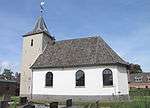 | ||
| Landfort, main building | 1825-1827 | Landfortseweg 4 | 51°51′11″N 6°24′25″E | 512220 | 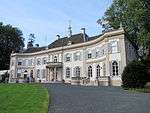 | ||
| Landfort, court and park | Landfortseweg bij 4 | 51°51′10″N 6°24′10″E | 512223 |  | |||
| Landfort, bridge | 1903 | Landfortseweg bij 4 | 51°51′10″N 6°24′10″E | 512224 | 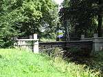 | ||
| Landfort, dovecote | 1825 | Landfortseweg bij 4 | 51°51′10″N 6°24′10″E | 512225 | 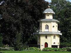 | ||
| Landfort, garden wall | Landfortseweg bij 4 | 51°51′10″N 6°24′10″E | 512226 | 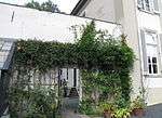 | |||
| Landfort, iron bridge | 1872 | Landfortseweg bij 4 | 51°51′10″N 6°24′10″E | 512227 | 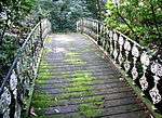 |
References
- ANWB Topografische Atlas Nederland, Topografische Dienst and ANWB, 2005.
- Gemeente Oude IJsselstreek website
This article is issued from Wikipedia. The text is licensed under Creative Commons - Attribution - Sharealike. Additional terms may apply for the media files.