Maya Research Program
The Maya Research Program is a US-based non-profit organization (501C3) that sponsors archaeological and ethnographic research in Middle America. Each summer since 1992, they have sponsored archaeological fieldwork at the ancient Maya site of Blue Creek in northwestern Belize.
The Program's goal is, first and foremost, to conduct research that adds to the body of scholarly knowledge and helps to better understand the past of the complex ancient societies of the Americas. Many affiliated scholars are internationally recognized as leaders in their fields. Recent support has come from the National Geographic Society, the National Science Foundation, the Foundation for the Advancement of Mesoamerican Studies, the Heinz Foundation, and the American Council of Learned Societies. In addition, the Blue Creek field school has been certified by the Registry of Professional Archaeologists.
 |
| Maya civilization |
|---|
| History |
| Preclassic Maya |
| Classic Maya collapse |
| Spanish conquest of the Maya |
Current Excavations
Understanding the Classic Collapse
What happened to Classic Maya civilization? Why did the entire society collapse—region wide—during a short crisis in the mid-ninth century A.D.? Was it persistent warfare? Agricultural or environmental collapse? Overpopulation? Drought? Or some combination . . . of some other factors altogether? Because of the extent of the Blue Creek site (from Middle Preclassic to the Terminal Classic collapse) and because of the length of time and extent of our studies, MRP is in a unique position to analyze a wealth of data that may provide critical insights into this mystery. This is an overarching focus of research over the coming years, into which all of our new projects will feed. This is at the vanguard of scholarship, impacting the debate about the Classic Maya collapse among scholars and institutions around the world.
Nojol Nah
Equally exciting is a newly discovered center of monumental architecture in our survey area. This may represent a suburban center connected to an allied polity of Blue Creek or even an entirely separate city-state. There is much to be learned from this new, major discovery in the context of a well-studied site like Blue Creek, and it will be a focus of MRP's work at the Blue Creek Field Station for years to come. Mapping of the new site by Blue Creek staff and volunteers began in the 2008 excavation season and will continue in 2011.
Chum Balam-Nal
Current efforts at Blue Creek are focused on excavation of the Chum Balam-Nal, and elite residential zone on the Bravo Escarpment, just south of Blue Creek’s main plaza. This effort began in 2009 and will continue for several years and is revealing a great deal about the relationships among the elites living in the city center and the "sub-elites" living some distance away. What was going on here as the Classic period drew to a close and Maya civilization began to collapse?
Wetlands Agriculture
Led by Sheryl & Tim Beach, continues long term investigations of ancient wetlands agricultural systems at Blue Creek and elsewhere in northern Belize.
Bedrock
In 2008, a wonderfully preserved, deeply buried Early Classic midden was discovered at the Bedrock site. Excavations of this group will continue in 2011.
The Site of Blue Creek

A Middle Preclassic through Terminal Classic Sequence
The earliest deposits discovered so far at Blue Creek come from a complex midden in front of and beneath the Temple of the Masks. During the 1995, 1996 and 1997 seasons, a large portion of the midden was excavated. By the Middle Preclassic period, Blue Creek was apparently a nucleated village engaged in complex communal ritual. No structural remains have yet been found from this period. The ceramics from the period exhibit a close affinity in the Middle Preclassic to those of coastal Belize rather than the Belize Valley.
The midden deposits at the Temple of the Masks also include a rich record of Late Preclassic activity. Moreover, it now appears that, by no later than the end of the Late Preclassic, the fundamental form of the Main Plaza was in place. Early phases of Structures 1, 4 and 6 were erected. An early phase of Str. 5 also probably existed (Pastrana 1995). However, it is believed that this building was raised at a later date. While most of these buildings were unimposing at this time, Structure 1 rose 8 meters above the plaza.
As at many sites, Cerros for example, this period saw the instatement of a royal lineage at Blue Creek. Overt indications of complex society include the creation of public and sacred space at Blue Creek marked by a major bloodletting cache which dedicates the Late Preclassic version of Structure 4. This cache was placed immediately in front of the basal step of Structure 4 and consisted of seven chert (Colha) bifaces, fragments of jade and coral, two jade earflares, five jade beads, a number of marine shells, 425 obsidian blades and flakes, and 27 obsidian cores. These were all compactly located and a fragment of preserved cloth found underneath them. This cache is the result of a ceremony which included large scale bloodletting and placement of a cotton bag of bloodletting paraphernalia and other offerings in front of the building.
This ceremony marked the dedication of Structure 4 and the establishment of central authority at Blue Creek. Once established, the centralized authority at Blue Creek grew rapidly and grew wealthy. Buildings on the Main Plaza were greatly expanded in the Early Classic. Structure 4, for example, was remodeled to an order of magnitude larger than its Late Preclassic counterpart. The final version of Structure 5 was built. This 50 meter long, six meter tall range building defined the west side of the Main Plaza. Structure 6 was converted from a low platform to a small, but significant range building, immediately west of the towering Structure 1.
Structure 1
The special nature of Structure 1 is clear not only from its Early Classic expansion, but from the nature of its superstructure. On top of this tall temple was not a typical southern lowlands temple, but an open colonnaded building (Driver 1995, 1996). The facade consisted of 16 round, masonry and marl columns and each end was open. The only similar structure in the region which may date from this period is Structure V at Kohunlich (Andrews 1987), but even this is uncertain. The existence of these structures indicates that the origin of columned buildings may be a southern lowlands innovation which was incorporated into later northern lowlands architecture, rather than an indicator of Terminal Classic/Early Postclassic interaction, as some have argued.
Structures 2 & 3
These two buildings define the east side of the Main Plaza at Blue Creek. They are virtually identical and were placed on a north-south line. It is believed that this is a regional variant of a E-Group Complex which is an astronomical observatory named after Group E at Uaxactun. From a point near the middle of the plaza, an observer would see the sun rise over the top of Structure 2 on the morning of the Summer Solstice and over the top of Structure 3 on the morning of the Winter Solstice. Of course, at the Spring and Fall Equinox, the sun would rise exactly at the midpoint between the two buildings. There are no accurate construction dates for these buildings, but they were probably built during the Early Classic period.
Structure 4
The Ritual Event
At about AD 500, a major ritual act occurred at Structure 4 on the south end of the Main Plaza. Not only does this event underscore the wealth of Blue Creek, but it marked a turning point in the history of the community. Much of the data regarding this deposit comes from the work of Pamela Weiss, who excavated the material (Guderjan and Weiss 1995; Weiss 1995)
In preparation for the ritual, a large part of the center of the penultimate stage of Structure 4 was removed to accommodate the construction of a masonry lined shaft, where later the sacrificial deposits would be made. Since the construction fill of Structure 4 is composed of loosely laid, large boulders, a large excavation was necessary to safely construct the shaft. This preparatory excavation was dug immediately outside of the superstructural building of Structure 4-2nd and reached a depth of 4.3 meters with a north-south dimension of 4.6 meters. On the eastern side a retaining wall was built to secure the excavation from wall collapse. The western limit of the prehistoric excavation is still being investigated.
After the initial excavation, the shaft was constructed, probably a few courses at a time, and the excavation refilled around the shaft. The shaft was stone lined, with a diameter of approximately 50 cm. and a depth of more than 3 meters. During the refilling around the shaft, numerous caches of pottery vessels were placed around the shaft. In total, more than 100 vessels were cached. Nearly all of them were of the type called "Blue Creek Orange". Blue Creek Orange is similar to but yet distinctive from types such as Garbut Creek Red. The caches were placed both in nested arrangements of three inverted vessels or laid down as rim-to-rim caches. All of the caches from this area were surrounded with small irregular disks of burned limestone, often called "hamburger stones". These are largely associated with Late Preclassic Termination Rituals at Cerros (Garber 1989:34). In addition to the pottery, fractured and complete jade beads, a stingray spine, and a bird leg bone was recovered from these caches (Guderjan and Weiss 1995).
The majority of the pottery vessels are low, outflaring-sided vessels with a matte orange slipped surface (Aquilla Orange). Some darkening occurring from firing is evident. Also, a blotchy post-fire darkening is apparent on some of the vessels. It appears that artifacts were placed in the bottom of the vessels. The vessels placed in, rather than around, the shaft were covered with incense which was burnt long enough to darken the vessels before their deposition. Also, several cylindrical censers were recovered which are similar to those later placed in the shaft.
The ritual which occurred after the shaft was constructed included a complex placement of individual caches. However, the ritual seems to have occurred over a short period of time, probably during a single day. This is evidenced by sherds from partially reconstructable vessels scattered throughout the fill of the shaft.
Three distinct deposits were sequentially placed in the shaft during the event. The lower portion of the shaft contained the bulk of the artifacts in caches 9A, 9B, 9C, 10 and 11. Included in this area were worked jades, ceramics, shells, a chert eccentric, and human finger bone. The second segment was separated from the first by a marl "cap" and contained ceramic sherds from a number of partially reconstructable vessels. The upper segment of the shaft contained only burnt organic material.
The first cache placed in the lowest portion of the shaft was Cache 12. This consisted of a large, cruciform, chert eccentric (Figure 4) and a small, unslipped, pinch pot. The chert eccentric was oriented to the cardinal directions and its north and south tips were broken off. The chert eccentric normally could be considered to be a symbol of creation and the world tree. However, its broken tips may negate its life-giving aspect (Weiss 1995). The complexity and planning involved in the entire process is seen in the placement of two other caches immediately outside of the shaft at this level. Each consisted of two vessels (Blue Creek Orange) placed rim-to-rim. Cache 13, containing an offering of mollusks, was placed on the north side, and Cache 14, containing a food residue, was placed on the south side of the shaft, so that the broken tips of the eccentric were pointing to these caches.
About a meter above Cache 12 within the shaft was Cache 11, which held multiple vessels of Blue Creek Orange. While the number of vessels has not been determined, the minimum number of vessels is 21. Cache 10 was another rim-to-rim placement containing 46 shells of 3 freshwater and terrestrial species. It was placed only a few centimeters above Cache 11.
About a meter above Cache 10, the shaft fill was capped with marl. The shaft fill in this area included diverse ceramic sherds and partially burnt wood and the remains of what was probably burning incense. While no intact vessels are present, multiple sherds from a number of vessels were recovered.
Cache 9B, placed on top of this marl surface, was the most dramatic of the individual caches found. It consisted of a rim-to-rim placement of two pottery vessels containing 356 artifacts, mostly jade beads (Figure 5). Cache 9C was another rim-to-rim placement containing four artifacts: a 10 x 4 cm, anthropomorphic, tubular bead, an anthropomorphic head pendant with an extended tongue and two other beads (Figure 6). This was placed directly south of Cache 9B on the same marl surface.
The climax of the ritual event was to cap the entire deposit with the massive limestone bannerstone, 74 centimeters in diameter with a central opening fashioned by grinding and exhibiting polish from use, and an uncarved stela, 1.48 meters in length, that laid prone over the northern portion of the bannerstone. The smoke of the burning incense wafted out of the deposit and around the prone stela (Figure 7). The ritual event was ended by the snuffing of the incense when additional construction material was used to bury the shaft opening.
Dating the Event
The dating of this ritual event is based upon ceramic comparative analysis, two radiocarbon samples from within the shaft and two radiocarbon samples from the area around the shaft which was excavated to accommodate the shaft and then refilled. Dos Arroyos Orange-Polychromes associated with the shaft and other Manik ceramic complex (Tikal) material fix a date of approximately AD 250-550. In addition, a few Teotihuacan sherds were found in the shaft.
Radiocarbon dates from within the shaft were selected from quite different elevations. One was retrieved from the uppermost carbonized organic deposit and was separated from the rest of the ritual by a marl cap. The other sample came from the lowest level of the shaft. The corrected dates are 10 years from one another: 1440 +/- 110 BP (Beta-75432) and 1450 +/- 100 BP (Beta-76278). When the samples were cleaned in preparation for analysis, a large amount of wood was extracted from the completely organic sample indicating that the fire had been quickly extinguished.
The radiocarbon dates from caches in the fill around the shaft generally corroborate this date. One corrected date from Cache 21 was 1870 +/- 50 (Beta-82949) and a corrected AMS date from Cache 14 was 1950 +/- 50. These Late Preclassic dates are clearly much too early, as the building itself is definitively Early Classic in style with supporting ceramic evidence. However, the dated material could have come from recycled fill from the earlier version of Str. 4.
Consequently, the information has been interpreted to indicate that the ritual filling of the shaft occurred about 1450 BP (500 AD). However, it is possible that the shaft was in place somewhat earlier. One piece of information which makes this dubious is the relative placement of Caches 12, 13, and 14. The chert eccentric in Cache 12 was clearly placed with full knowledge of the precise location (outside of tmjmhe shaft) of Caches 13 and 14. It seems unlikely that their locations could be that precisely known if such a substantial period of time had elapsed since their placement.
Structure 5
This is a long "Range Building" which was excavated by Dale Pastrana in 1993, 1994 and 1995. The top or superstructure of the building consists of a single, 75-meter-long, vaulted (stone-roofed) room with 7 doors and open ends. This room is accessed via a 13-step central staircase. Built in the Early Classic period, Pastrana argues that it functioned as a viewing gallery for events in the Main Plaza.
Structure 6
It was originally believed that this small Range Building was a late addition to the Main Plaza architecture. However, excavations by Dale Pastrana in 1995 showed that this was originally built during the Late Preclassic period with much of the other architecture at the site. A carved stela stood in front of Structure 6 until the 1970s when looting occurred at the site.
Structure 7 - Ballcourt
The Ballcourt was built at the same time as the very large platform underneath it. However, it is not yet known when this occurred. The presence of a ballcourt at Blue Creek may reflect the community's status as an independent polity. The rest of the Ballcourt Platform may have been used for specialized craft activities in support of the royalty.
Structure 9
At the southern end of Area B is the Temple of the Masks (Structure 9), another dramatic statement as to the nature of Blue Creek in the Early Classic period (Haines 1995). The earliest phase of the building (Str. 9-I) dates to the Late Preclassic and is built on top of Middle and Late Preclassic midden deposits. However, by the mid-Early Classic, architecture of the temple is typical of Petan temples, with a single room superstructure on top of a steeply inclined substructure. Access to the superstructure was gained by a broad central staircase. Unlike most such buildings in the Peten, though, the Temple of the Masks has a large staircase outset, near the top of the stairs. Similar outsets are seen are Altun Ha (Pendergast 1979, 1982) and Kakabish (Guderjan 1996).
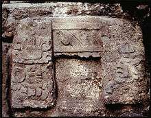
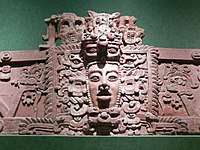
The facade of the outset is adorned with a complex five paneled, deep relief stucco frieze which included at least two and probably three anthropomorphic masks. Two of these are in excellent condition but the left face has been destroyed. Despite their Early Classic style, these were originally dated these to the Late Classic based on confusing ceramics from an associated cache and argued that this was an archaizing trait (Grube, et al. 1995). However, after the 1995 season, it was recognized that this was not correct and that these masks actually date to the Early Classic period.
Both faces have chin straps or bib motifs. The center image has closed eyes, hollowed cheeks, a slack jaw and a protruding tongue. The face is wearing an elaborate head-dress decorated with volutes shaped like an Ahaw glyph. The volutes represent smoke or foliation and may be the Early Classic form of the phonetic symbol ya (Thompson's T126) Grube (1990) has shown the Ahaw sign, when not used as a day sign, is a logogram for the word nik or "flower". This was interpreted as marking the building as a nikteil na or "flower house" (Grube, et al. 1995). These are specific houses for dancing and counsels (Freidel, et al. 1993: 257-263) and may have also served as accession houses for rulers.
Another element of the stucco facade supports this interpretation as well. A single glyph is located above the recessed panel between the two masks. This is interpreted as representing a sky or earth band with the phonetic value ki, meaning "heart" or "center" (Grube, et al. 1995). This glyph may represent the axis mundi (Grube et al. 1995), which Freidel (1992:127) associates with Ahaw (kingship) and political authority.
The presence of a nikteil na at Blue Creek is strong evidence that the community was ruled by an independent, local royal lineage. This is distinctly contrary to Adams' interpretation that the region was subsumed under a macro-state based at Tikal at the time (Adams 1995). Instead, Blue Creek and probably other medium-sized sites are fundamentally independent and self-governing. At Blue Creek, it would appear that an independent royal lineage was established in the latter part of the Late Preclassic Period which then flourished economically and politically in the Early Classic period. However, all of this came to an abrupt end sometime during the first half of the sixth century.
Structure 13
Dramatically reflecting the changes which occurred in the Late Classic is the Str. 13 Courtyard (Gilgan 1996). In the Early Classic, this courtyard was a small plaza consisting of Structures 10, 12 and 13. Normally, such sacred space could not be converted to other uses by the same population. Nevertheless, the addition of Structures 11 and 14 did exactly that in the Late Classic. Structure 14 was a large vaulted, single room and Structure 11 was partially vaulted and partially a ramada-type room. The construction of these structures violated the normal rules of sacredness of plaza space by enclosing part of the plaza and secularizing it into elite residential space. This act underscores the transition of Blue Creek from a regional power to what was probably an outpost of another kingdom.
Structure 15
Structure 15 is a low set of vaulted rooms. Excavations by Bob Baker and David Bianco show that building was constructed in the Late Classic Period and that the back wall of the building fell off the steep platform edge. This building may have been constructed when the Str. 13 Courtyard was converted from sacred, open space to a secular, elite residence.
Structure 19 Courtyard.
The Str. 19 Courtyard is a Yucatecan style, patio-quad residence. Built in the Early Classic period, the courtyard underwent repeated remodellings for several hundred years. Excavations by Bob Lichtenstein have shown that the residents buried at least six individuals ate different times in a bench in a small east side room of the complex. It is not known who these individuals were. However, this was, arguably, the residence of the king of Blue Creek. So, these may be family members.
Structure 24, The Temple of the Obsidian Warrior.
We have done almost no work at this building. However, in the 1970s, the building was very badly looted. Mary Neivens was working at another site at the time and came to visit Blue Creek. She documented several hundred flakes of obsidian, probably associated with a tomb which was destroyed by looters.
Sources
- The Nature of an Ancient Maya City: Resources, Interaction and Power at Blue Creek, Belize. University of Alabama Press, Tuscaloosa (2007). Reviewed: Antiquity 83: 529-534 (2009).
- New information about the Demise of a Maya City: Fieldwork at Blue Creek, Belize, 2006 and 2007. Senior author with Timothy Beach, Steve Bozarth, Colleen Hanratty, Sheryl Luzzadder-Beach, and Timothy Preston. Mexicon 35:2:15-22 (2010).
- Understanding the Causes of Abandonment in the Maya Lowlands. Senior author with Tim Beach, Sheryl Luzzadder-Beach, Steve Bozarth. Archaeological Review of Cambridge 24:2:99-122 (2009).
- A Review of Human and Natural Changes in Maya Lowlands Wetlands over the Holocene. Co-author with Timothy Beach, Sheryl Luzzadder-Beach, Steve Bozarth, Nicholas Dunning, John Jones, Jon Lohse, Sarah Millspaugh, and Tripti Bhattacharya. Quaternary Science Review 28: 1-15 (2009)
- The Maya Blue Creek Project, senior author with Colleen Hanratty. Minerva; The International Review of Ancient Art & Archaeology. May/June 23–25. London (2007). A Thriving Non-Royal Lineage at Blue Creek: Evidence from a Sequence of Burials Caches and Architecture, senior author with Colleen Hanratty. Acta Mesoamericana 19 (2006).
- A Thriving Non-Royal Lineage at Blue Creek: Evidence from a Sequence of Burials Caches and Architecture, senior author with Colleen Hanratty. Acta Mesoamericana 19 (2006).
- E-Groups, Pseudo E-Groups, and the Development of the Classic Maya Identity in the Eastern Petén. Ancient Mesoamerica 17: 1: 1-8 (2006).
- Lessons Learned from a Volunteer Based Research Project in Central America. Archaeological Record 5:1:33-35 (2005).
- Recreating the Maya Cosmos: Early Classic Caches at Blue Creek. Acta Mesoamericana 14:33-39 (2004).
- Public Architecture, Ritual and Temporal Dynamics at the Maya Center of Blue Creek. Ancient Mesoamerica 15:2:1-17 (2004).
- Biosilicate Analysis of Residue in Maya Dedicatory Cache Vessels from Blue Creek, Belize, co-author with Steven Bozarth. Journal of Archaeological Science 31:2:205-215 (2004).