Maryland Route 639
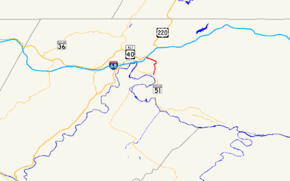
Maryland Route 639 (MD 639) is a state highway in the U.S. state of Maryland. The state highway runs 2.79 miles (4.49 km) from MD 51 in Evitts Creek north to Interstate 68 (I-68), U.S. Route 40 (US 40), US 220, and US 40 Alternate in Cumberland. MD 639 provides access to Allegany College of Maryland and Western Maryland Regional Medical Center, which opened in November 2009.[2] The Willowbrook Road portion of the state highway was constructed in the late 1960s. MD 639 was extended south to MD 51 in 2008.
| ||||
|---|---|---|---|---|
 Maryland Route 639 highlighted in red | ||||
| Route information | ||||
| Maintained by MDSHA | ||||
| Length | 2.79 mi[1] (4.49 km) | |||
| Existed | 1970–present | |||
| Major junctions | ||||
| South end | ||||
| North end | ||||
| Location | ||||
| Counties | Allegany | |||
| Highway system | ||||
| ||||

Route description
_at_Interstate_68_and_U.S._Route_40_(National_Freeway)_in_Cumberland%2C_Allegany_County%2C_Maryland.jpg)
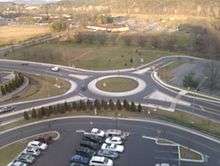
MD 639 begins at an intersection with MD 51 (Oldtown Road) in Evitts Creek. The state highway heads north as two-lane Messick Road, paralleling the east side of Evitts Creek. At the northern end of Messick Road, MD 639 turns onto Williams Road, which continues to follow Evitts Creek. After crossing the creek, MD 639 turns north onto Willowbrook Road, a two-lane road that passes through two roundabouts at the entrance to the Western Maryland Regional Medical Center and then enters the city limits of Cumberland. After passing the entrance to Allegany College of Maryland, MD 639 turns northwest, passing Country Club Road before reaching its northern terminus at a diamond interchange with the I-68, US 40, and US 220 (National Freeway). The roadway continues as US 40 Alternate (Baltimore Avenue), which heads toward downtown Cumberland.[1][3]
History
The first section of present-day MD 639 to become a state highway was the Williams Road segment, which was designated part of MD 52 by 1939.[4] MD 52 was removed from the state highway system in 1956.[5] Willowbrook Road between I-68 and Country Club Road was improved as a county highway in 1968 concurrent with the completion of the Cumberland Thruway east of downtown Cumberland.[6] Willowbrook Road was extended on a new alignment south to Williams Road and brought into the state highway system as MD 639 in 1970.[7] In 2008, MD 639 was extended south along Williams Road and Messick Road to its present southern terminus at MD 51.[8]
Junction list
The entire route is in Allegany County.
| Location | mi[1] | km | Destinations | Notes | |
|---|---|---|---|---|---|
| Evitts Creek | 0.00 | 0.00 | Southern terminus | ||
| 0.76 | 1.22 | Williams Road east | Former MD 52; MD 639 turns west on Williams Road | ||
| 1.34 | 2.16 | Williams Road west – Cumberland | Former MD 52; MD 639 turns north on Willowbrook Road | ||
| Cumberland | 1.56 | 2.51 | Roundabout | ||
| 1.78 | 2.86 | Entrance to Allegany College of Maryland | Unsigned MD 639A | ||
| 2.23 | 3.59 | Country Club Road | Unsigned MD 639B | ||
| 2.79 | 4.49 | Northern terminus; eastern terminus of US 40 Alternate; I-68 Exit 44 | |||
| 1.000 mi = 1.609 km; 1.000 km = 0.621 mi | |||||
Auxiliary routes
See also

References
- Highway Information Services Division (December 31, 2013). Highway Location Reference. Maryland State Highway Administration. Retrieved 2010-11-09.
- Allegany County (PDF).
- Sawyers, Michael A. (2010-02-07). "Closed Hospitals Mean Neighborhood Changes". Cumberland Times–News. Cumberland, MD: Community Newspaper Holdings. Retrieved 2010-11-10.
- Google (2010-03-05). "Maryland Route 639" (Map). Google Maps. Google. Retrieved 2010-03-05.
- Maryland State Roads Commission (1939). General Highway Map: State of Maryland (Map). Baltimore: Maryland State Roads Commission.
- Maryland State Roads Commission (1956). Maryland: Official Highway Map (Map). Baltimore: Maryland State Roads Commission.
- Maryland State Roads Commission (1968). Maryland: Official Highway Map (Map). Baltimore: Maryland State Roads Commission.
- Maryland State Roads Commission (1970). Maryland: Official Highway Map (Map). Baltimore: Maryland State Roads Commission.
- Highway Information Services Division (December 31, 2008). Highway Location Reference. Maryland State Highway Administration. Retrieved 2010-11-09.
- Allegany County (PDF).
- Google (2010-11-09). "Maryland Route 639B" (Map). Google Maps. Google. Retrieved 2010-11-09.
External links
![]()