Tschingelhörner
The Tschingelhörner (also spelled Tschingelhoren) are a chain of mountain peaks in the Glarus Alps, located on the border between the Swiss cantons of Glarus and Graubünden. They are composed of several summits on a 1 km long ridge, of which the highest is named Grosses Tschingelhorn (2,849 m). The mountain is located between Elm and Flims, west of the Segnas Pass (2,627 m). East of the main summit is the Martinsloch, a 6-by-18-metre (20-by-60 ft) triangular breakthrough, or hole, through which the sun shines at particular times of the year.
| Tschingelhörner | |
|---|---|
| Grosses Tschingelhorn | |
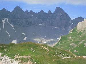 The Tschingelhörner (main summit on the right) with the Martinsloch visible on the right | |
| Highest point | |
| Elevation | 2,849 m (9,347 ft) |
| Prominence | 109 m (358 ft) [1] |
| Parent peak | Piz Grisch |
| Coordinates | 46°53′53.8″N 9°13′16.8″E |
| Geography | |
 Tschingelhörner Location in Switzerland | |
| Location | Glarus/Graubünden, Switzerland |
| Parent range | Glarus Alps |
The mountain is part of the Swiss Tectonic Arena Sardona and is a UNESCO World Heritage Site.[2]
References
- Retrieved from the Swisstopo topographic maps and Google Earth. The key col is located west of the summit at approximately 2,740 metres.
- https://whc.unesco.org/en/list/1179
This article is issued from Wikipedia. The text is licensed under Creative Commons - Attribution - Sharealike. Additional terms may apply for the media files.