Mariehamn
Mariehamn (![]()
Mariehamn | |
|---|---|
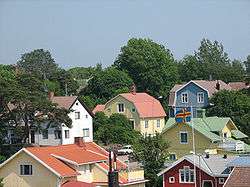 View of Mariehamn | |
 Coat of arms | |
| Nickname(s): De tusen lindarnas stad[1] | |
 Location of Mariehamn in Finland | |
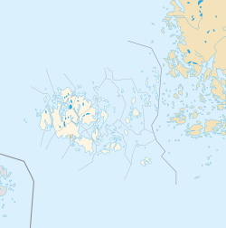 Mariehamn Location within the Åland Islands 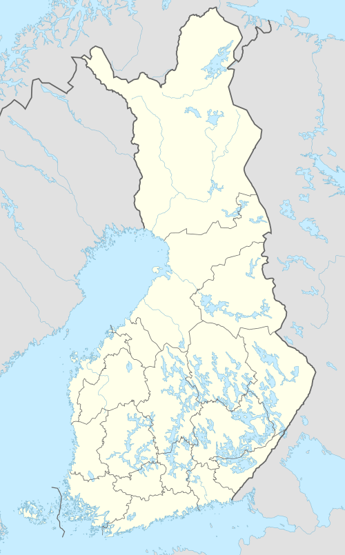 Mariehamn Mariehamn (Finland) | |
| Coordinates: 60°06′N 019°56′E | |
| Country | |
| Region | Åland |
| Sub-region | Mariehamn |
| Charter | 1861 |
| Named for | Maria Alexandrovna |
| Government | |
| • Mayor | Barbara Heinonen |
| Area (2018-01-01)[2] | |
| • Total | 20.75 km2 (8.01 sq mi) |
| • Land | 11.79 km2 (4.55 sq mi) |
| • Water | 8.96 km2 (3.46 sq mi) |
| Area rank | 311th largest in Finland |
| Population (2019-01-31)[3] | |
| • Total | 11,775 |
| • Rank | 89th largest in Finland |
| • Density | 998.73/km2 (2,586.7/sq mi) |
| Population by native language | |
| • Swedish | 87.7% (official) |
| • Finnish | 5.8% |
| • Others | 6.5% |
| Population by age | |
| • 0 to 14 | 14.8% |
| • 15 to 64 | 67.8% |
| • 65 or older | 17.4% |
| Time zone | UTC+02:00 (EET) |
| • Summer (DST) | UTC+03:00 (EEST) |
| Municipal tax rate[6] | 16.5% |
| Website | www.mariehamn.ax |
History
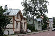
The town was named after the Russian empress Maria Alexandrovna. Mariehamn was founded in 1861, around the village of Övernäs, in what was at the time part of the municipality of Jomala. The city has since expanded and incorporated more of Jomala territory. Mariehamn was built according to a very regular scheme which is well-preserved. One of the oldest streets is Södragatan where many wooden houses dating from the 19th century can be seen. Following the First World War Mariehamn was home to the Mariehamn Grain Fleet.[7]
Transportation
Harbours
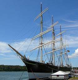
The city is located on a peninsula. It has two important harbours, one located on the western shore and one on the eastern shore, which are ice-free for nearly the whole year, and have no tides.[8] The Western Harbour is an important international harbour with daily traffic to Sweden, Estonia and mainland Finland. A powerful incentive for Baltic ferries to stop at Mariehamn is that, with respect to indirect taxation, Åland is not part of the EU customs zone and so duty-free goods can be sold aboard. Åland and Mariehamn have a reputable heritage in shipping. The Flying P-Liner Pommern museum ship is anchored in the Western Harbour. The Eastern Harbour features one of the largest marinas in Scandinavia. The famous Dutch steamer Jan Nieveen (now called F.P. von Knorring, after Åland teacher and vicar Frans Peter von Knorring) can also be found here.
Airport
Mariehamn Airport serves the city; it has scheduled flights on two airlines including Finnair.
Culture
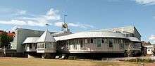
The city is an important centre for Åland media; both of the local newspapers (Ålandstidningen and Nya Åland), several radio stations and the local TV channels (TV Åland and Åland24) operate out of the city. The islanders are traditionally fond of reading, and had public libraries before 1920. A printing works was established in the town in 1891.[8] The municipal library, which was built in 1989, is one of the most interesting modern buildings.
Architecture
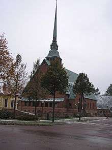
Mariehamn features several buildings drawn by Finnish architect Lars Sonck, who moved to Åland as a child. Buildings drawn by him include the church of Mariehamn (1927), the main building of the Åland Maritime College (1927) and the town hall (1939). Hilda Hongell also designed several buildings, although only a few are still standing.
Demographics
A chart on population increase.[9]
| People with a foreign background[10][11] | |
|---|---|
| Country of origin | Population (2017) |
| 1,093 (9.55%) | |
| 173 (1.51%) | |
| 163 (1.42%) | |
| 95 (0.83%) | |
| 92 (0.80%) | |
| 88 (0.77%) | |
| 86 (0.75%) | |
| 73 (0.64%) | |
| 55 (0.48%) | |
| 45 (0.39%) | |
Geography
Climate
Mariehamn has a transitional climate between humid continental climate with certain maritime influence as a result of the strong maritime moderation from being an island in the Baltic Sea. This renders summers to be cooler than both the Swedish and Finnish mainlands, with winters being similar in cold to the adjacent coastal part of Sweden but milder than Finland's mainland. The coldest temperature at Mariehamn airport was -32.9 C (-27.2F) in February 1979, and the warmest temperature on record was 31.3 C (88.3F) in July 1941. [12]
| Climate data for Mariehamn Airport normals 1981-2010, extremes 1914 - present | |||||||||||||
|---|---|---|---|---|---|---|---|---|---|---|---|---|---|
| Month | Jan | Feb | Mar | Apr | May | Jun | Jul | Aug | Sep | Oct | Nov | Dec | Year |
| Record high °C (°F) | 10.9 (51.6) |
10.5 (50.9) |
17.0 (62.6) |
21.1 (70.0) |
26.7 (80.1) |
29.4 (84.9) |
31.3 (88.3) |
30.7 (87.3) |
24.8 (76.6) |
19.0 (66.2) |
14.1 (57.4) |
10.4 (50.7) |
30.7 (87.3) |
| Average high °C (°F) | 0.3 (32.5) |
−0.3 (31.5) |
2.4 (36.3) |
7.6 (45.7) |
13.6 (56.5) |
17.5 (63.5) |
20.7 (69.3) |
19.6 (67.3) |
14.8 (58.6) |
9.6 (49.3) |
4.6 (40.3) |
1.7 (35.1) |
9.3 (48.7) |
| Daily mean °C (°F) | −2.1 (28.2) |
−3.1 (26.4) |
−0.6 (30.9) |
3.7 (38.7) |
9.1 (48.4) |
13.3 (55.9) |
16.7 (62.1) |
15.8 (60.4) |
11.4 (52.5) |
6.9 (44.4) |
2.6 (36.7) |
−0.4 (31.3) |
6.1 (43.0) |
| Average low °C (°F) | −5.0 (23.0) |
−6.3 (20.7) |
−3.7 (25.3) |
0.0 (32.0) |
4.3 (39.7) |
8.6 (47.5) |
12.2 (54.0) |
11.6 (52.9) |
7.7 (45.9) |
4.0 (39.2) |
0.2 (32.4) |
−3.1 (26.4) |
2.5 (36.5) |
| Record low °C (°F) | −32.3 (−26.1) |
−32.9 (−27.2) |
−25.0 (−13.0) |
−18.9 (−2.0) |
−6.5 (20.3) |
−3.2 (26.2) |
0.1 (32.2) |
−0.5 (31.1) |
−6.7 (19.9) |
−11.8 (10.8) |
−20.0 (−4.0) |
−28.9 (−20.0) |
−32.9 (−27.2) |
| Average precipitation mm (inches) | 53 (2.1) |
35 (1.4) |
38 (1.5) |
31 (1.2) |
35 (1.4) |
53 (2.1) |
52 (2.0) |
76 (3.0) |
61 (2.4) |
70 (2.8) |
71 (2.8) |
59 (2.3) |
634 (25) |
| Average precipitation days | 17 | 13 | 12 | 9 | 10 | 10 | 9 | 13 | 12 | 16 | 17 | 17 | 155 |
| Mean monthly sunshine hours | 39 | 74 | 130 | 207 | 297 | 296 | 312 | 235 | 163 | 91 | 41 | 26 | 1,911 |
| Source 1: FMI climatological normals for Finland 1981-2010[13] | |||||||||||||
| Source 2: record highs and lows 1961- present[14] | |||||||||||||
Twin towns and sister cities
Mariehamn is twinned with:[16]
Notable person
- Anders Överström, professional footballer
References
- "Turism - Mariehamns stad". Mariehamns stad. Retrieved 23 January 2020.
- "Area of Finnish Municipalities 1.1.2018" (PDF). National Land Survey of Finland. Retrieved 30 January 2018.
- "Suomen virallinen tilasto (SVT): Väestön ennakkotilasto [verkkojulkaisu]. Tammikuu 2019" (in Finnish). Statistics Finland. Retrieved 15 March 2019.
- "Population according to language and the number of foreigners and land area km2 by area as of 31 December 2008". Statistics Finland's PX-Web databases. Statistics Finland. Retrieved 29 March 2009.
- "Population according to age and gender by area as of 31 December 2008". Statistics Finland's PX-Web databases. Statistics Finland. Retrieved 28 April 2009.
- "List of municipal and parish tax rates in 2011". Tax Administration of Finland. 29 November 2010. Retrieved 13 March 2011.
- Derby., W L A (1937). "Mariehamn's Grain Fleet - Shipping Wonders of the World". Shipping Wonders of the World (21 July 1937): 746–749.
- Prothero, G.W. (1920). The Åland Islands. Great Britain. Foreign Office. Historical Section. p. 5.
- "PX-Web - Select variable and values".
- "Archived copy". Archived from the original on 2018-06-29. Retrieved 2018-09-26.CS1 maint: archived copy as title (link)
- https://helda.helsinki.fi/bitstream/handle/10138/15734/2009nro8.pdf?sequence=1&isAllowed=y
- "FMI normals 1981-2010" (PDF). fmi.fi. Retrieved 26 April 2016.
- "FMI open data". FMI. Retrieved 26 April 2016.
- Mariehamns stads vänorter. Accessed July 14, 2015
External links
| Wikimedia Commons has media related to Mariehamn. |
- Official website (in Swedish)
- Official Tourist Gateway of Mariehamn - Maarianhamina

- Map of Mariehamn
- Mariehamn. Tourist route (in Russian)
| Authority control |
|
|---|