Mapia Atoll
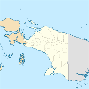
Mapia Atoll (Indonesian: Kepulauan Mapia), historically known as the Freewill Islands or San David, is an atoll in the Pacific Ocean. It is located in Papua province of Indonesia, approximately 290 kilometers north of the city of Manokwari and 630 kilometers from the islands of Palau. It consists of two main islands, Bras (Berasi) and Pegun (Mapia), the smaller Fanildo, and two minor islands, Bras Kecil (Little Bras) and Fanildo Kecil (Little Fanildo). The islands constitute a part of Supiori Regency, Papua.
 Mapia Atoll Location in Papua  Mapia Atoll Location in Western New Guinea  Mapia Atoll Location in Indonesia | |
| Geography | |
|---|---|
| Location | Pacific Ocean |
| Coordinates | 0°54′32″N 134°18′17″E |
| Total islands | 5 |
| Administration | |
| Province | |
The atoll was once part of the Spanish Empire under the name of Güedes. According to Spanish researcher Emilio Pastor in a paper submitted to his government in 1948, a number of small islands in Micronesia (Kapingamarangi or Coroa, Mapia or Güedes, Ocea or Matador, and Rongerik or Pescadores) continue legally under Spanish sovereignty. This is because the text of the German–Spanish Treaty of 1899 which transferred sovereignty of certain Spanish possessions in the Pacific to Germany, namely the Northern Mariana Islands (except Guam) and the Caroline Islands (including Palau), failed to include these smaller islands. Although the Spanish government studied the case in 1949 and accepted this interpretation, it has never formally reclaimed the islands.[1]
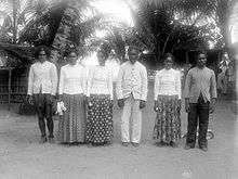
The extinct Mapia language was spoken on the islands until the end of the 20th century. As of 2000, according to Ethnologue, there was one elderly speaker of the language remaining on the islands.[2]
References
- Yahoo News (Spanish) - "Las cuatro islas españolas perdidas en el Océano Pacífico"
- "Ethnologue 14 report for language code:mpy". archive.ethnologue.com. Retrieved 2016-01-07.