Maine State Route 73
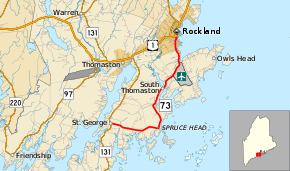
State Route 73 (abbreviated SR 73) is part of Maine's system of numbered state highways, a coastal route located in southern Knox County. It runs for 10.7 miles (17.2 km) from an intersection with SR 131 in St. George to an intersection with U.S. Route 1 (US 1) in Rockland.
| ||||
|---|---|---|---|---|
 | ||||
| Route information | ||||
| Maintained by MaineDOT | ||||
| Length | 10.68 mi[1] (17.19 km) | |||
| Existed | 1963–present | |||
| Major junctions | ||||
| South end | ||||
| North end | ||||
| Location | ||||
| Counties | Knox | |||
| Highway system | ||||
| ||||

Route description
SR 73 begins in St. George at SR 131 about eight miles (13 km) north of Marshall Point. SR 73 runs roughly parallel to SR 131 on the coastline, passing through the towns of South Thomaston and Owls Head without any major junctions. SR 73 crosses into Rockland and proceeds due north into the town center, where it ends at US 1.
SR 73 is known as Seal Harbor Road in St. George, Spruce Head Road in Spruce Head, Elm Street in South Thomaston, and Weskeag Road, Ingraham Drive and South Main Street in Rockland. Knox County Regional Airport is located along SR 73 in Owls Head.[2]
Junction list
The entire route is in Knox County.
| Location | mi[1] | km | Destinations | Notes | |
|---|---|---|---|---|---|
| St. George | 0.00 | 0.00 | |||
| Rockland | 10.68 | 17.19 | |||
| 1.000 mi = 1.609 km; 1.000 km = 0.621 mi | |||||
References
- "Maine DOT Map Viewer". Maine Office of GIS. Retrieved September 16, 2017.
- Google (September 16, 2017). "Maine State Route 73" (Map). Google Maps. Google. Retrieved September 16, 2017.