Maine State Route 153
State Route 153 (SR 153) is part of Maine's system of numbered state highways. It runs 4.68 miles (7.53 km) from an intersection with SR 6 and SR 16 to an intersection with Smith Lane near Sebec Lake in Dover-Foxcroft. The route is also known as Greeley's Landing Road.
| ||||
|---|---|---|---|---|
 | ||||
| Route information | ||||
| Maintained by MaineDOT | ||||
| Length | 4.68 mi[1] (7.53 km) | |||
| Existed | 1925–present | |||
| Major junctions | ||||
| South end | ||||
| North end | Cotton Brook Road in Dover-Foxcroft | |||
| Location | ||||
| Counties | Piscataquis | |||
| Highway system | ||||
| ||||

Route description
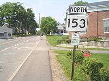
State Route 153 heading northbound through Dover-Foxcroft
SR 153 begins at its southern terminus in Dover-Foxcroft at an intersection with SR 6 / SR 16 (just north of its intersection with SR 15). It then heads north for just less than 5 miles (8.0 km) and ends at intersection with Cotton Brook Road south of Sebec Lake.[2]
Junction list
The entire route is in Dover-Foxcroft, Piscataquis County.
| mi[1] | km | Destinations | Notes | ||
|---|---|---|---|---|---|
| 0.00 | 0.00 | ||||
| 4.68 | 7.53 | Smith Lane | |||
| 1.000 mi = 1.609 km; 1.000 km = 0.621 mi | |||||
References
- Maine DOT Map Viewer (Map). Maine Office of GIS. Retrieved October 21, 2017.
- Google (October 21, 2017). "Maine State Route 153" (Map). Google Maps. Google. Retrieved October 21, 2017.
External links
This article is issued from Wikipedia. The text is licensed under Creative Commons - Attribution - Sharealike. Additional terms may apply for the media files.