Maibara, Shiga
Maibara (米原市, Maibara-shi) is a city in Shiga Prefecture, Japan.
Maibara 米原市 | |
|---|---|
 The Shinkansen streaks past Mt. Ibuki before reaching Maibara Station. | |
 Flag  Emblem | |
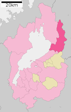 Location of Maibara in Shiga | |
 Maibara Location in Japan | |
| Coordinates: 35°19′N 136°17′E | |
| Country | Japan |
| Region | Kansai |
| Prefecture | Shiga |
| Government | |
| • Mayor | Michio Hirao |
| Area | |
| • Total | 250.46 km2 (96.70 sq mi) |
| Population (October 1, 2016) | |
| • Total | 38,473 |
| • Density | 150/km2 (400/sq mi) |
| Time zone | UTC+9 (JST) |
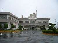
| City hall address | 3-3 Shimotara, Maibara-shi, Shiga-ken 521-8501 |
| Website | www |
As of October 1, 2016, the city has an estimated population of 38,473 and a population density of 150 persons per km². The total area is 250.46 km².
History
The modern city of Maibara was established on February 14, 2005, from the merger of the towns of Maihara, Santō and Ibuki (all from in Sakata District). The adjacent town of Ōmi was merged into Maibara on October 1, 2005. The new city name was based on the name of Japan Railways' Maibara Station which many people in Japan knew as a station on the Tōkaidō Shinkansen Line.
Maibara was struck by an F2 tornado on June 29, 2018. The tornado caused major damage to homes and injured 8 people.
Geography
The city is in the northeast region of Shiga Prefecture. Its area occupies 5.1% of Shiga's total land area. The west end of the city fronts Lake Biwa, while the mountainous east side borders on Sekigahara, Gifu Prefecture.
Mt. Ibuki is in the northeastern part of the prefecture. It is Maibara's most prominent landmark and designated as one of Japan's 100 most famous peaks. The Anegawa River and Amanogawa River empty into Lake Biwa and about 70 percent of the city comprises forest land. The city thus boasts an abundance of water and greenery.
Tourism
Maibara is mainly served by the JR Tōkaidō Line along which you can find Kashiwabara, Ōmi-Nagaoka, Samegai, and Maibara stations. Maibara Station serves the Shinkansen: From Tokyo, Maibara can be reached in about two and a half hours.
The city has a number of major sightseeing spots:
- Mt. Ibuki — With an elevation of 1,377.4 meters, Mt. Ibuki is Shiga Prefecture's tallest mountain and a popular spot for skiing in winter and camping and hiking in the warmer months. A gondola and ski lifts carry visitors to the top which affords fine views of Lake Biwa and the surrounding area. The nearest station is Omi-Nagaoka Station.
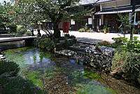
- Samegai Trout Farm — Established over a century ago, this is the largest trout farm in Asia and with many ponds. There is a shallow pond where children can try catch (and release) the trout. Riverside restaurants serve fresh trout.
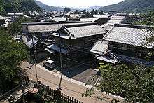
- Nakasendō stage towns — The Nakasendō was an old highway linking Kyoto with Edo (present-day Tokyo). The highway had 67 stages and three of them were Kashiwabara, Samegai and Bamba in Maibara city. Even today, you can see remnants of these stage towns established for highway travelers to lodge and trade.
- Amanogawa River — In June, fireflies come out at night. Parts of the river are designated as a protected areas for fireflies.
- Lake Biwa — The lakeshore road is very scenic on fine days.
Festivals & events
- Samegai Baikamo Flowers — Underwater flowers which bloom in Jizogawa River
- Maibara Hikiyama Festival — Parade of ornate floats which have a small stage featuring kabuki performed by children. Early October.
External links
| Wikimedia Commons has media related to Maibara, Shiga. |
- Maibara City official website (in Japanese)
Ōtsu (capital) | ||
| Core city |
| |
| Cities | ||
| Districts | ||
| Authority control |
|
|---|