Mahajanapadas
The Mahājanapadas (Sanskrit: महाजनपद, lit. 'great realm', from maha, "great", and janapada "foothold of a people") were sixteen kingdoms or oligarchic republics that existed in ancient India from the sixth to fourth centuries BCE. Two of them were most probably ganatantras (republics) and others had forms of monarchy. Ancient Buddhist texts like the Anguttara Nikaya[3] make frequent reference to sixteen great kingdoms and republics which had evolved and flourished in a belt stretching from Gandhara in the northwest to Anga in the eastern part of the Indian subcontinent and included parts of the trans-Vindhyan region,[4] prior to the rise of Buddhism in India.[5]
Mahājanapadas | |||||||||||||
|---|---|---|---|---|---|---|---|---|---|---|---|---|---|
| c. 600 BCE–c. 345 BCE | |||||||||||||
.png) Map of the 16 Mahājanapadas.[2] | |||||||||||||
| Capital | Various | ||||||||||||
| Common languages | Prakrits and Sanskrit | ||||||||||||
| Religion | Vedic Hinduism Śramaṇa (Buddhism and Jainism) | ||||||||||||
| Government | Republics Monarchies | ||||||||||||
| Historical era | Iron Age | ||||||||||||
• Established | c. 600 BCE | ||||||||||||
• Disestablished | c. 345 BCE | ||||||||||||
| |||||||||||||
Part of a series on the |
|---|
| History of India |
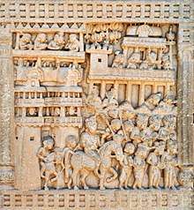
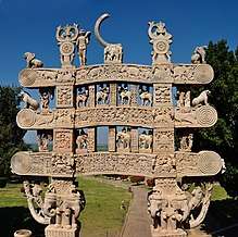 Satavahana gateway at Sanchi, 1st century CE |
|
Ancient
|
|
Classical
|
|
|
|
Early modern
|
|
Modern
|
|
Related articles
|
| Outline of South Asian history | ||||||||||||||||||||||||||||||||||||||||||||
|---|---|---|---|---|---|---|---|---|---|---|---|---|---|---|---|---|---|---|---|---|---|---|---|---|---|---|---|---|---|---|---|---|---|---|---|---|---|---|---|---|---|---|---|---|
_without_national_boundaries.svg.png) | ||||||||||||||||||||||||||||||||||||||||||||
|
Palaeolithic (2,500,000–250,000 BC) |
||||||||||||||||||||||||||||||||||||||||||||
|
Neolithic (10,800–3300 BC)
|
||||||||||||||||||||||||||||||||||||||||||||
|
Chalcolithic (3500–1500 BC)
|
||||||||||||||||||||||||||||||||||||||||||||
|
Bronze Age (3300–1300 BC)
|
||||||||||||||||||||||||||||||||||||||||||||
|
Iron Age (1500–200 BC)
|
||||||||||||||||||||||||||||||||||||||||||||
|
Middle Kingdoms (230 BC – AD 1206) |
||||||||||||||||||||||||||||||||||||||||||||
|
Late medieval period (1206–1526)
|
||||||||||||||||||||||||||||||||||||||||||||
|
Early modern period (1526–1858)
|
||||||||||||||||||||||||||||||||||||||||||||
|
Colonial states (1510–1961)
|
||||||||||||||||||||||||||||||||||||||||||||
|
Periods of Sri Lanka
|
||||||||||||||||||||||||||||||||||||||||||||
|
National histories |
||||||||||||||||||||||||||||||||||||||||||||
|
Specialised histories
|
||||||||||||||||||||||||||||||||||||||||||||
The 6th–5th century BCE is often regarded as a major turning point in early Indian history; it saw the emergence of India's first large cities after the demise of the Indus Valley Civilization, as well as the rise of sramana movements (including Buddhism and Jainism) which challenged the religious orthodoxy of the Vedic Period.
Archaeologically, this period corresponds in part to the Northern Black Polished Ware culture.[6]
Overview
The term "Janapada" literally means the foothold of a people. The fact that Janapada is derived from Jana points to an early stage of land-taking by the Jana people for a settled way of life. This process of first settlement on land had completed its final stage prior to the times of the Buddha and Pāṇini. The Pre-Buddhist north-west region of the Indian sub-continent was divided into several Janapadas demarcated from each other by boundaries. In Pāṇini's "Ashtadhyayi", Janapada stands for country and Janapadin for its citizenry. Each of these Janapadas was named after the Kshatriya people (or the Kshatriya Jana) who had settled therein.[7][8][9][10][11][12][13][14] Buddhist and other texts only incidentally refer to sixteen great nations (Solasa Mahajanapadas) which were in existence before the time of the Buddha. They do not give any connected history except in the case of Magadha. The Buddhist Anguttara Nikaya, at several places,[15] gives a list of sixteen great nations:
Another Buddhist text, the Digha Nikaya, mentions only twelve Mahajanapadas from the above list and omits four of them (Assaka, Avanti, Gandhara, and Kamboja).[16]
Chulla-Niddesa, another ancient text of the Buddhist canon, adds Kalinga to the list and substitutes Yona for Gandhara, thus listing the Kamboja and the Yona as the only Mahajanapadas from Uttarapatha.[17][18]
The Vyākhyāprajñapti (or the Bhagavati Sutra), a sutra of Jainism, gives a different list of sixteen Mahajanapadas:
The author of the Bhagavati Sutra (or the Vyākhyāprajñapti) has a focus on the countries of Madhydesa and of the far east and south only. He omits the nations from Uttarapatha like the Kamboja and Gandhara. The more extended horizon of the Bhagvati and the omission of all countries from Uttarapatha "clearly shows that the Bhagvati list is of later origin and therefore less reliable."[19]
List of Mahajanapadas
Anga
The first reference to the Angas is found in the Atharva-Veda where they find mention along with the Magadhas, Gandharis and the Mujavats, apparently as a despised people. The Jaina Prajnapana ranks Angas and Vangas in the first group of Aryan people. It mentions the principal cities of ancient India.[20] It was also a great center of trade and commerce and its merchants regularly sailed to distant Suwanabhumi. Anga was annexed by Magadha in the time of Bimbisara. This was the one and only conquest of Bimbisara.
Assaka
The country of Assaka or the Ashmaka tribe was located in Dakshinapatha or southern India. It included areas in present-day Andhra Pradesh, Telangana, and Maharashtra.[21] In Gautama Buddha's time, many of the Assakas were located on the banks of the Godavari River (south of the Vindhya mountains). The capital of the Assakas was Potana or Potali, which corresponds present-day Bodhan in Telangana and Paudanya of Mahabharata.[22] The Ashmakas are also mentioned by Pāṇini. They are placed in the north-west in the Markendeya Purana and the Brhat Samhita. The river Godavari separated the country of the Assakas from that of the Mulakas (or Alakas). The country of Assaka lay outside the pale of Madhyadesa. It was located on a southern high road, the Dakshinapatha. At one time, Assaka included Mulaka and abutted Avanti.[23]
Avanti
.jpg)
The country of the Avantis was an important kingdom of western India and was one of the four great monarchies in India in the post era of Mahavira and Buddha, the other three being Kosala, Vatsa and Magadha. Avanti was divided into north and south by the river Narmada. Initially, Mahishamati (Mahissati) was the capital of Southern Avanti, and Ujjaini (Sanskrit: Ujjayini) was of northern Avanti, but at the times of Mahavira and Buddha, Ujjaini was the capital of integrated Avanti. The country of Avanti roughly corresponded to modern Malwa, Nimar and adjoining parts of today's Madhya Pradesh. Both Mahishmati and Ujjaini stood on the southern high road called Dakshinapatha which extended from Rajagriha to Pratishthana (modern Paithan). Avanti was an important centre of Buddhism and some of the leading theras and theris were born and resided there. King Nandivardhana of Avanti was defeated by king Shishunaga of Magadha. Avanti later became part of the Magadhan empire.
Chedi
The Chedis, Chetis or Chetyas had two distinct settlements of which one was in the mountains of Nepal and the other in Bundelkhand near Kausambi. According to old authorities, Chedis lay near Yamuna midway between the kingdom of Kurus and Vatsas. In the mediaeval period, the southern frontiers of Chedi extended to the banks of the river Narmada. Sotthivatnagara, the Sukti or Suktimati of Mahabharata, was the capital of Chedi. The Chedis were an ancient people of India and are mentioned in the Rigveda, with their king Kashu Chaidya.[24]
The location of the capital city, Suktimati, has not been established with certainty. Historian Hem Chandra Raychaudhuri and F. E. Pargiter believed that it was in the vicinity of Banda, Uttar Pradesh.[24] Archaeologist Dilip Kumar Chakrabarti has proposed that Suktimati can be identified as the ruins of a large early historical city, at a place with the modern-day name Itaha, on the outskirts of Rewa, Madhya Pradesh.[25]
Gandhara
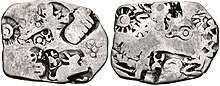
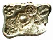
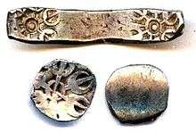 Coin of Early Gandhara Janapada: AR Shatamana and one-eighth Shatamana (round), Taxila-Gandhara region, c. 600–300 BCE.
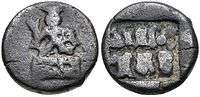
._Circa_220-185_BC.jpg) A coin of Takshashila, portrays a tree flanked by a hill surmounted by a crescent and a Nandipada above a swastika.[26]
A coin of Takshashila, portrays a tree flanked by a hill surmounted by a crescent and a Nandipada above a swastika.[26]
The wool of the Gandharis is referred to in the Rigveda. The Gandharas and their king figure prominently as strong allies of the Kurus against the Pandavas in the Mahabharata war. The Gandharas were furious people, well-trained in the art of war. According to Puranic traditions, this Janapada was founded by Gandhara, son of Aruddha, a descendant of Yayati. The princes of this country are said to have come from the line of Druhyu who was a famous king of the Rigvedic period and one of the five sons of king Yayati of lunar dynasty. The river Indus watered the lands of Gandhara. Taksashila and Pushkalavati, the two cities of this Mahajanapada, are said to have been named after Taksa and Pushkara, the two sons of Bharata, a prince of [[Ayodhya]the younder brother of Lord Rama]. According to Vayu Purana (II.36.107), the Gandharas were destroyed by Pramiti (a.k.a. Kalika) at the end of Kaliyuga. Pāṇini mentioned both the Vedic form Gandhari as well as the later form Gandhara in his Ashtadhyayi. The Gandhara kingdom sometimes also included Kashmira.[27] Hecataeus of Miletus (549-468) refers to Kaspapyros (Kasyapura or Purushapura, i.e., modern day Peshawar) as a Gandharic city. According to Gandhara Jataka, at one time, Gandhara formed a part of the kingdom of Kashmir. The Jataka also gives another name Chandahara for Gandhara.
Gandhara Mahajanapada of Buddhist traditions included territories of east Afghanistan, and north-west of the Panjab (modern districts of Peshawar (Purushapura) and Rawalpindi). Its later capital was Taksashila (Prakrit for Taxila). The Taksashila University was a renowned centre of learning in ancient times, where scholars from all over the world came to seek higher education. Pāṇini, the Indian genius of grammar and Kautiliya are the world-renowned products of Taxila University. King Pukkusati or Pushkarasarin of Gandhara in the middle of the 6th century BCE was the contemporary of king Bimbisara of Magadha. Gandhara was located on the grand northern high road (Uttarapatha) and was a centre of international commercial activities. According to one group of scholars, the Gandharas and Kambojas were cognate people.[28][29][30] It is also contended that the Kurus, Kambojas, Gandharas and Bahlikas were cognate people.[31] According to Dr T. L. Shah, the Gandhara and Kamboja were nothing but two provinces of one empire and were located coterminously, hence influencing each other's language.[32] Naturally, they may have once been a cognate people.[33] Gandhara was often linked politically with the neighboring regions of Kashmir and Kamboja.[34]
Kamboja
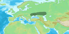
Kambojas are also included in the Uttarapatha. In ancient literature, the Kamboja is variously associated with the Gandhara, Darada and the Bahlika (Bactria). Ancient Kamboja is known to have comprised regions on either side of the Hindukush. The original Kamboja was located in eastern Oxus country as neighbor to Bahlika, but with time, some clans of the Kambojas appear to have crossed the Hindukush and planted colonies on its southern side also. These latter Kambojas are associated with the Daradas and Gandharas in Indian literature and also find mention in the Edicts of Ashoka. The evidence in the Mahabharata and in Ptolemy's Geography distinctly supports two Kamboja settlements.[35] The cis-Hindukush region from Nurestan up to Rajauri in southwest of Kashmir sharing borders with the Daradas and the Gandharas constituted the Kamboja country.[36] The capital of Kamboja was probably Rajapura (modern Rajori) in the south-west of Kashmir. The Kamboja Mahajanapada of the Buddhist traditions refers to this cis-Hindukush branch of ancient Kambojas.[37]
The trans-Hindukush region including the Pamirs and Badakhshan which shared borders with the Bahlikas (Bactria) in the west and the Lohas and Rishikas of Sogdiana/Fergana in the north, constituted the Parama-Kamboja country.[38] The trans-Hindukush branch of the Kambojas remained pure Iranian but a large section of the Kambojas of cis-Hindukush appears to have come under Indian cultural influence. The Kambojas are known to have had both Iranian as well as Indian affinities.[39][40][41][42][43][44][45][46][47][48][49]
The Kambojas were also a well known republican people since Epic times. The Mahabharata refers to several Ganah (or Republics) of the Kambojas.[50] Kautiliya's Arthashastra[51] and Ashoka's Edict No. XIII also attest that the Kambojas followed republican constitution. Pāṇini's Sutras,[52] though tend to convey that the Kamboja of Pāṇini was a Kshatriya monarchy, but "the special rule and the exceptional form of derivative" he gives to denote the ruler of the Kambojas implies that the king of Kamboja was a titular head (king consul) only.[53] According to Buddhist texts, the first fourteen of the above Mahajanapadas belong to Majjhimadesa (Mid India) while the last two belong to Uttarapatha or the north-west division of Jambudvipa.
In a struggle for supremacy that followed in the 6th/5th century BCE, the growing state of the Magadhas emerged as the predominant power in ancient India, annexing several of the Janapadas of the Majjhimadesa. A bitter line in the Brahmin Puranas laments that Magadhan emperor Mahapadma Nanda exterminated all Kshatriyas, none worthy of the name Kshatriya being left thereafter. This obviously refers to the Kasis, Kosalas, Kurus, Panchalas, Vatsyas and other neo-Vedic tribes of the east Panjab of whom nothing was ever heard except in the legend and poetry. (The Nandas usurped the throne of Shishunaga dynasty c. 345 BCE, thus founding the Nanda Empire.)[54]
The Kambojans and Gandharans, however, never came into direct contact with the Magadhan state until Chandragupta and Kautiliya arose on the scene. But these nations also fell prey to the Achaemenids of Persia during the reign of Cyrus (558–530 BCE) or in the first year of Darius. Kamboja and Gandhara formed the twentieth and richest satrapy of the Achaemenid Empire. Cyrus I is said to have destroyed the famous Kamboja city called Kapisi (modern Begram) in Paropamisade.
Kashi
The kingdom was located in the region around its capital Varanasi, bounded by the Varuna and Asi rivers in the north and south which gave Varanasi its name. Before Buddha, Kasi was the most powerful of the sixteen Mahajanapadas. Several jataka tales bear witness to the superiority of its capital over other cities in India and speak highly of its prosperity and opulence. These stories tell of the long struggle for supremacy between Kashi and the three kingdoms of Kosala, Anga and Magadha. Although King Brihadratha of Kashi conquered Kosala, Kashi was later incorporated into Kosala by King Kansa during Buddha's time. The Kashis along with the Kosalas and Videhans find mention in Vedic texts and appear to have been a closely allied people. The Matsya Purana and Alberuni spell Kashi as Kausika and Kaushaka respectively. All other ancient texts read Kashi.
Kosala
The country of Kosala was located to the north-west of Magadha, with its capital at Ayodhya. Its territory corresponded to the modern Awadh (or Oudh) in Central and Eastern Uttar Pradesh. It had the river Ganges for its southern, the river Gandak (Narayani) for its eastern, and the Himalaya mountains for its northern boundary. It finds mention as the center of Vedic Dharma. Its kings allied with the Devatas in various wars against the Daityas, Rakshas, and Asuras. Koshala and Ayodhya hold a central place in the Hindu scriptures, Itihas, and Purana. Raghuvansha-Ikshvakuvansha was the longest continuous dynasty; Lord Rama was a king in this dynasty. Other great kings were Prithu, Harishchandra, and Dilip, who are each mentioned in different Puranas, Ramayan, and Mahabharat. According to these texts, Koshala was the most powerful and biggest kingdom ever in the recorded history.
Later, the kingdom was ruled by the famous king Prasenajit during the era of Mahavira and Buddha, followed by his son Vidudabha (Virudhaka). King Prasenajit was highly educated. His position was further improved by a matrimonial alliance with Magadha: his sister was married to Bimbisara and part of Kasi was given as dowry. There was, however, a struggle for supremacy between king Pasenadi (Prasenajit) and king Ajatashatru of Magadha which was finally settled once the confederation of Lichchavis became aligned with Magadha. Kosala was ultimately merged into Magadha when Vidudabha was Kosala's ruler. Ayodhya, Saketa, Banaras, and Sravasti were the chief cities of Kosala.
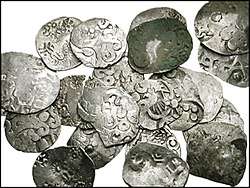
Kuru
_circa_350-315_BCE.jpg)
The Puranas trace the origin of Kurus from the Puru-Bharata family. Kuru was born after 25 generations of Puru's dynasty, and after 15 generations of Kuru, Kauravas and Pandavas were born. Aitareya Brahmana locates the Kurus in Madhyadesha and also refers to the Uttarakurus as living beyond the Himalayas. According to the Buddhist text Sumangavilasini,[56] the people of Kururashtra (the Kurus) came from the Uttarakuru. Vayu Purana attests that Kuru, son of Samvarsana of the Puru lineage, was the eponymous ancestor of the Kurus and the founder of Kururashtra (Kuru Janapada) in Kurukshetra. The country of the Kurus roughly corresponded to the modern Thanesar, state of Delhi, and Meerut district of Uttar Pradesh. According to the Jatakas, the capital of the Kurus was Indraprastha (Indapatta) near modern Delhi which extended seven leagues. At Buddha's time, the Kuru country was ruled by a titular chieftain (king consul) named Korayvya. The Kurus of the Buddhist period did not occupy the same position as they did in the Vedic period but they continued to enjoy their ancient reputation for deep wisdom and sound health. The Kurus had matrimonial relations with the Yadavas, the Bhojas, Trigratas, and the Panchalas. There is a Jataka reference to king Dhananjaya, introduced as a prince from the race of Yudhishtra. Though a well known monarchical people in the earlier period, the Kurus are known to have switched to a republican form of government during the 6th to 5th centuries BCE. In the 4th century BCE, Kautiliya's Arthashastra also attests the Kurus following the Rajashabdopajivin (king consul) constitution.
Magadha
The Magadha was one of the most prominent and prosperous of mahajanapadas. The capital city Pataliputra (Patna, Bihar) was situated on the confluence of major rivers like the Ganga, Son, Punpun and Gandak. The alluvial plains of this region and its proximity to the copper and iron rich areas of Bihar and Jharkhand helped the kingdom to develop good quality weapons and support the agrarian economy. Its location at the centre of the highways of trade of those days contributed to its wealth. All these factors helped Magadha to emerge as the most prosperous state of that period.
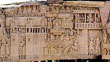
_at_Rajagriha%2C_the_visit_of_Bimbisara.jpg)
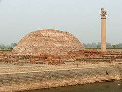
The kingdom of the Magadhas roughly corresponded to the modern districts of Patna and Gaya in southern Bihar and parts of Bengal in the east. The capital city of Pataliputra was bound in the north by the river Ganges, in the east by the river Champa, in the south by the Vindhya mountains and in the west by the river Sona. During Buddha's time its boundaries included Anga. Its earliest capital was Girivraja or Rajagaha (modern Rajgir in the Nalanda district of Bihar). The other names for the city were Magadhapura, Brihadrathapura, Vasumati, Kushagrapura and Bimbisarapuri. It was an active center of Jainism in ancient times. The first Buddhist Council was held in Rajagaha in the Vaibhara Hills. Later on, Pataliputra became the capital of Magadha.
Malla

The Mallas are frequently mentioned in Buddhist and Jain works. They were a powerful people dwelling in Northern South Asia. According to Mahabharata, Panduputra Bhimasena is said to have conquered the chief of the Mallas/Malls in the course of his expedition in Eastern India. During the Buddhist period, the Mallas/Malls Kshatriya were a republican people with their dominion consisting of nine territories[57] corresponding to the nine confederated clans. These republican states were known as Gana. Two of these confederations – one with Kuśināra (modern Kasia near Gorakhpur) as its capital and the second with Pava (modern Padrauna, 12 miles from Kasia) as the capital – had become very important at the time of Buddha. Kuśināra and Pava are very important in the history of Buddhism and Jainism since Lord Buddha and Lord Mahavira, the 24th Tirthankara took their last meals at Kushinara and Pava/Pavapuri respectively. Buddha was taken ill at Pava and died at Kusinara, whereas lord Mahavira took his Nirvana at Pavapuri. It is widely believed that Lord Gautam died at the courtyard of King Sastipal Mall of Kushinagar/Kushinara. Kushinagar is now the centre of the Buddhist pilgrimage circle which is being developed by the tourism development corporation of Uttar Pradesh.
The Mallas, like the Licchavis, are mentioned by Manusmriti as Vratya Kshatriyas. They are called Vasishthas (Vasetthas) in the Mahapparnibbana Suttanta. The Mallas originally had a monarchical form of government but later they switched to one of Samgha (republic), the members of which called themselves rajas. The Mallas appeared to have formed an alliance with the Licchhavis for self-defense but lost their independence not long after Buddha's death and their dominions were annexed to the Magadhan empire.

Matsya
The country of the Matsya or Machcha tribe lay to the south of the Kurus and west of the Yamuna, which separated them from the Panchalas. It roughly corresponded to the former state of Jaipur in Rajasthan, and included the whole of Alwar with portions of Bharatpur. The capital of Matsya was at Viratanagara (modern Bairat) which is said to have been named after its founder king Virata. In Pali literature, the Matsyas are usually associated with the Surasenas. The western Matsya was the hill tract on the north bank of the Chambal. A branch of Matsya is also found in later days in the Vizagapatam region. The Matsyas had not much political importance of their own during the time of Buddha. King Sujata ruled over both the Chedis and Matsyas, thus showing that Matsya once formed a part of the Chedi kingdom.
Panchala
The Panchalas occupied the country to the east of the Kurus between the mountains and river Ganges. It roughly corresponded to modern Budaun, Farrukhabad and the adjoining districts of Uttar Pradesh. The country was divided into Uttara-Panchala and Dakshina-Panchala. The northern Panchala had its capital at Adhichhatra or Chhatravati (modern Ramnagar in the Bareilly District), while southern Panchala had its capital at Kampilya or Kampil in the Farrukhabad District. The famous city of Kanyakubja or Kanauj was situated in the kingdom of Panchala. Originally a monarchical clan, the Panchals appear to have switched to republican corporation in the 6th and 5th centuries BCE. In the 4th century BCE, Kautiliya's Arthashastra also attests the Panchalas as following the Rajashabdopajivin (king consul) constitution.
Surasena
The country of the Surasenas lay to the east of Matsya and west of Yamuna. This corresponds roughly to the Brij region of Uttar Pradesh, Haryana and Rajasthan. and Gwalior region of Madhya Pradesh. It had its capital at Madhura or Mathura. Avantiputra, the king of Surasena, was the first among the chief disciples of Buddha, through whose help Buddhism gained ground in Mathura country. The Andhakas and Vrishnis of Mathura/Surasena are referred to in the Ashtadhyayi of Pāṇini. In Kautiliya's Arthashastra, the Vrishnis are described as sangha or republic. The Vrishnis, Andhakas and other allied tribes of the Yadavas formed a sangha and Vasudeva (Krishna) is described as the sangha-mukhya. Mathura, the capital of Surasena, was also known at the time of Megasthenes as the centre of Krishna worship. The Surasena kingdom had lost its independence on annexation by the Magadhan empire.
Vajji
Vajji (Sanskrit: Vṛji) or Vrijji was a confederacy of neighbouring clans including the Licchavis and one of the principal mahājanapadas of Ancient India. The area they ruled constitutes the region of Mithila in northern Bihar and their capital was the city of Vaishali.[59]
Both the Buddhist text Anguttara Nikaya and the Jaina text Bhagavati Sutra (Saya xv Uddesa I) included Vajji in their lists of solasa (sixteen) mahājanapadas.[60] The name of this mahājanapada was derived from one of its ruling clans, the Vṛjis. The Vajji state is indicated to have been a republic. This clan is mentioned by Pāṇini, Chanakya and Xuanzang.[61]
Vatsa or Vamsa
The Vatsas or Vamsas are called to be a branch of the Kurus. The Vatsa or Vamsa country corresponded with the territory of modern Allahabad in Uttar Pradesh. It had a monarchical form of government with its capital at Kausambi (identified with the village Kosam, 38 miles from Allahabad).[62] Kausambi was a very prosperous city where a large number of wealthy merchants resided. It was the most important entreport of goods and passengers from the north-west and south. Udayana was the ruler of Vatsa in the 6th-5th century BCE. He was very powerful, warlike and fond of hunting. Initially king Udayana was opposed to Buddhism, but later became a follower of Buddha and made Buddhism the state religion. Udayana's mother, Queen Mrigavati, is notable for being one of the earliest known female rulers in Indian history.
The period of the Vedas
Brahmarshi-desha, 'the county of the holy sages,' includes the territories of the Kurus, Matsyas, Panchalas and Shurasenas (i.e., the eastern half of the State of Patiala and of the Delhi division of the Punjab, the Alwar State and adjacent territory in Rajputana, the region which lies between the Ganges and the Jumna, and the Muttra District in the United Provinces).[63]
See also
| Part of a series on |
| Indo-European topics |
|---|
 |
|
|
Philology
|
|
Origins |
|
Archaeology Pontic Steppe
Caucasus East Asia Eastern Europe Northern Europe Pontic Steppe Northern/Eastern Steppe Europe
South Asia Steppe Europe Caucasus India |
|
Peoples and societies Indo-Aryans Iranians
East Asia Europe East Asia Europe
Indo-Aryan Iranian
|
|
Religion and mythology
Indo-Aryan Iranian Others Europe
|
|
- Janapada
- Iron Age India
- Epic India
- Indo-Aryan peoples
- Rigvedic tribes
References
- Lal, Deepak (2005). The Hindu Equilibrium: India C.1500 B.C. - 2000 A.D. Oxford University Press. p. xxxviii. ISBN 978-0-19-927579-3.
- Lal, Deepak (2005). The Hindu Equilibrium: India C.1500 B.C. - 2000 A.D. Oxford University Press. p. xxxviii. ISBN 978-0-19-927579-3.
- Anguttara Nikaya I. p 213; IV. pp 252, 256, 261.
- Singh, Upinder (2008). A History of Ancient and Early Medieval India: From the Stone Age to the 12th Century. Delhi: Pearson Education. pp. 260–4. ISBN 978-81-317-1120-0.
- 16 Mahajanapadas - Sixteen Mahajanapadas, 16 Maha Janapadas India, Maha Janapada Ancient India. Iloveindia.com. Retrieved on 2013-07-12.
- J.M. Kenoyer (2006), "Cultures and Societies of the Indus Tradition. In Historical Roots" in the Making of ‘the Aryan’, R. Thapar (ed.), pp. 21–49. New Delhi, National Book Trust.
- India as Known to Panini: A Study of the Cultural Material in the Ashṭādhyāyī, 1963, p 427
- Vasudeva Sharana Agrawala - India; India in the Time of Patañjali, 1968, p 68 Dr B. N. Puri - India;
- Socio-economic and Political History of Eastern India, 1977, p 9, Y. K Mishra - Bihar (India)
- Tribes of Ancient India, 1977, p 18 Mamata Choudhury - Ethnology
- Tribal Coins of Ancient India, 2007, p xxiv Devendra Handa - Coins, Indic - 2007
- The Journal of the Numismatic Society of India, 1972, p 221 Numismatic Society of India - Numismatics
- A History of Pāli Literature, 2000 Edition, p 648 B. C. Law
- Some Ksatriya Tribes of Ancient India, 1924, pp 230-253, Dr B. C. Law.
- Anguttara Nikaya: Vol I, p 213, Vol IV, pp 252, 256, 260 etc.
- Digha Nikaya, Vol II, p 200.
- Chulla-Niddesa (P.T.S.), p 37.
- Lord Mahāvīra and his times, 1974, p 197, Dr Kailash Chand Jain; The History and Culture of the Indian People, 1968, p lxv, Dr Ramesh Chandra Majumdar, Bharatiya Vidya Bhavan, Bhāratīya Itihāsa Samiti; Problems of Ancient India, 2000, p 7, K. D. Sethna.
- Political History of Ancient India, 1996, p. 86; History & Culture of Indian People, Age of Imperial Unity, pp. 15–16
- Digha Nikaya
- Tiwari, Anshuman; Sengupta, Anindya (10 August 2018). Laxminama: Monks, Merchants, Money and Mantra. Bloomsbury Publishing. p. 307. ISBN 9789387146808.
- Sen, Sailendra Nath (1999). Ancient Indian History and Civilization. New Age International. p. 109. ISBN 9788122411980.
- Dr Bhandarkaar
- Raychaudhuri, Hem Chandra (1923), Political history of ancient India, from the accession of Parikshit to the extinction of the Gupta dynasty, p. 66
- Chakrabarti, Dilip Kumar (2000), "Mahajanapada States of Early Historic India", in Hansen, Mogens Herman (ed.), A Comparative Study of Thirty City-state Cultures: An Investigation, p. 387, ISBN 9788778761774
- "Post-Mauryan (Punjab). Taxila (local coinage). Circa 220–185 BC. Æ (17x18mm, 7.71 g)". www.cngcoins.com. Classical Numismatic Group Inc. Retrieved 28 June 2017.
- Jataka No 406.
- Revue des etudes grecques 1973, p. 131, Ch-Em Ruelle, Association pour l'encouragement des etudes grecques en France.
- Early Indian Economic History, 1973, pp. 237, 324, Rajaram Narayan Saletore.
- Myths of the Dog-man, 199, p. 119, David Gordon White; Journal of the Oriental Institute, 1919, p 200; Journal of Indian Museums, 1973, p 2, Museums Association of India; The Pāradas: A Study in Their Coinage and History, 1972, p 52, Dr B. N. Mukherjee - Pāradas; Journal of the Department of Sanskrit, 1989, p 50, Rabindra Bharati University, Dept. of Sanskrit- Sanskrit literature; The Journal of Academy of Indian Numismatics & Sigillography, 1988, p 58, Academy of Indian Numismatics and Sigillography - Numismatics; Cf: Rivers of Life: Or Sources and Streams of the Faiths of Man in All Lands, 2002, p. 114, J. G. R. Forlong.
- Journal of the Oriental Institute, 1919, p 265, Oriental Institute (Vadodara, India) - Oriental studies; For Kuru-Kamboja connections, see Dr Chandra Chakraberty's views in: Literary history of ancient India in relation to its racial and linguistic affiliations, pp. 14,37, Vedas; The Racial History of India, 1944, p. 153, Chandra Chakraberty - Ethnology; Paradise of Gods, 1966, p 330, Qamarud Din Ahmed - Pakistan.
- Ancient India, History of India for 1000 years, four Volumes, Vol I, 1938, pp. 38, 98 by Dr T. L. Shah.
- James Fergusson observes: "In a wider sense, name Gandhara implied all the countries west of Indus as far as Candhahar" (The Tree and Serpent Worship, 2004, p. 47, James Fergusson).
- Encyclopedia Americana, 1994, p 277, Encyclopedias and Dictionaries.
- Ptolemy's Geography mentions Tambyzoi located in eastern Bactria (Ancient India as Described by Ptolemy: Being a Translation of the Chapters ... 1885, p. 268, John Watson McCrindle - Geography, Ancient; Barrington Atlas of the Greek and Roman World, History - 2000, p. 99, (editors) Richard J. A. Talbert) and Ambautai people located to south of Hindukush Mountains (Geography 6.18.3; See map in McCrindle, p. 8). Dr S. Levi has identified Tambyzoi with Kamboja (Indian Antiquary, 1923, p. 54; Pre Aryan and Pre Dravidian in India, 1993, p. 122, Dr Sylvain Lévi, Dr Jean Przyluski, Jules Bloch, Asian Educational Services) while land of Ambautai has also been identified by Dr Michael Witzel (Harvard University) with Sanskrit Kamboja Electronic Journal of Vedic Studies, Vol. 5, 1999, issue 1 (September), Dr. M. Witzel; Indo-Aryan Controversy: Evidence and Inference in Indian History, 2005, p 257, Laurie L. Patton, Edwin Bryant; The Indo-Aryans of Ancient South Asia: Language, Material Culture and Ethnicity, 1995, p. 326, George Erdosy.
- MBH VII.4.5; II.27.23.
- See: Problems of Ancient India, 2000, pp. 5-6; cf: Geographical Data in the Early Puranas, p. 168.
- MBH II.27.27.
- Vedic Index I, p. 138, Macdonnel, Dr Keith.
- Ethnology of Ancient Bhārata, 1970, p. 107, Dr Ram Chandra Jain.
- The Journal of Asian Studies; 1956, p. 384, Association for Asian Studies, Far Eastern Association (U.S.).
- Balocistān: siyāsī kashmakash, muz̤mirāt va rujḥānāt; 1989, p. 2, Munīr Aḥmad Marrī.
- India as Known to Panini: A Study of the Cultural Material in the Ashṭādhyāyī; 1953, p. 49, Dr Vasudeva Sharana Agrawala.
- Afghanistan, p. 58, W. K. Fraser, M. C. Gillet.
- Afghanistan, its People, its Society, its Culture, Donal N. Wilber, 1962, pp. 80, 311 etc.
- Iran, 1956, p. 53, Herbert Harold Vreeland, Clifford R. Barnett.
- Geogrammatical Dictionary of Sanskrit (Vedic): 700 Complete Revisions of the Best Books..., 1953, p. 49, Dr Peggy Melcher, Dr A. A. McDonnel, Dr Surya Kanta, Dr Jacob Wackernagel, Dr V. S. Agarwala.
- Geographical and Economic Studies in the Mahābhārata: Upāyana Parva, 1945, p. 33, Dr Moti Chandra - India.
- A Grammatical Dictionary of Sanskrit (Vedic): 700 Complete Reviews of the ..., 1953, p. 49, Dr Vasudeva Sharana Agrawala, Surya Kanta, Jacob Wackernagel, Arthur Anthony Macdonell, Peggy Melcher - India.
- MBH 7/91/39.
- Arthashastra 11/1/4.
- Ashtadhyayi IV.1.168–175.
- Hindu Polity: A Constitutional History of India in Hindu Times, Parts I and II., 1955, p. 52, Dr Kashi Prasad Jayaswal - Constitutional history; Prācīna Kamboja, jana aura janapada =: Ancient Kamboja, people and country, 1981, Dr Jiyālāla Kāmboja - Kamboja (Pakistan).
- Panda, Harihar (2007), Prof. H.C. Raychaudhuri, as a Historian, Northern Book Centre, p. 28, ISBN 978-81-7211-210-3
- Marshall p.59
- II. p 481
- Kalpa Sutra; Nirayavali Sutra
- Asiatic Mythology by J. Hackin p.83ff
- Olivelle, Patrick (13 July 2006). "Between the Empires: Society in India 300 BCE to 400 CE". Oxford University Press – via Google Books.
- Raychaudhuri Hemchandra (1972), Political History of Ancient India, Calcutta: University of Calcutta, pp. 85–6
- Raychaudhuri Hemchandra (1972), Political History of Ancient India, Calcutta: University of Calcutta, p.107
- Rohan L. Jayetilleke (5 December 2007). "The Ghositarama of Kaushambi". Daily News. Archived from the original on 4 June 2011. Retrieved 29 October 2008.
- Rapson, E. J. (1914). Ancient India, from the earliest times to the first century, A.D. (pp. 50–51).
Further reading
- R. C. Majumdar and A. D. Pusalker, eds. The History and Culture of the Indian People. Bharatiya Vidya Bhavan, Bombay 1951.
- Sethna, K. D. (1989). Ancient India in a new light. New Delhi: Aditya Prakashan.
- Sethna, K. D. (2000). Problems of ancient India. New Delhi: Aditya Prakashan.