Magra
The Magra is a 62-kilometre (39 mi) long river of Northern Italy, which runs through Pontremoli, Filattiera, Villafranca in Lunigiana and Aulla in the province of Massa-Carrara (Tuscany); Santo Stefano di Magra, Vezzano Ligure, Arcola, Sarzana and Ameglia in the province of La Spezia (Liguria).
| Magra | |
|---|---|
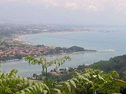 The mouth of the Magra | |
.png) | |
| Location | |
| Country | Italy |
| Physical characteristics | |
| Source | |
| • location | Between Monte Borgognone and Monte Tavola |
| • elevation | 1,200 m (3,900 ft) |
| Mouth | Tyrrhenian Sea |
• coordinates | 44.0481°N 9.9876°E |
• elevation | 0 m (0 ft) |
| Length | 62 km (39 mi) |
| Basin size | 1,686 km2 (651 sq mi) |
| Discharge | |
| • average | 40 m3/s (1,400 cu ft/s) |
In Roman times, it was known as the Macra and marked the eastern boundary of the territory of Liguria.
The river's drainage basin occupies around 1,686 km2 (651 sq mi). Its most important tributary is the Vara which joins the Magra from the right within the commune of Santo Stefano di Magra.
On 8 April 2020 around 10:20 local time, a 260 metre long road bridge across the Magra at Albiano Magra near Aulla collapsed. Very few vehicles were using the bridge at the time due to the coronavirus lockdown then in force, and only two people were injured.[1][2][3]
References
- "Italy bridge collapse: Two drivers survive". BBC News. 8 April 2020. Retrieved 8 April 2020.
- "Lockdown keeps casualty figure low as Italian bridge collapses". The Guardian. London. 8 April 2020. Retrieved 9 April 2020.
- "Bridge Collapses in Italy, Newest Crumbling Infrastructure". The New York Times. 8 April 2020. Retrieved 9 April 2020.
External links
![]()