Lyell Canyon
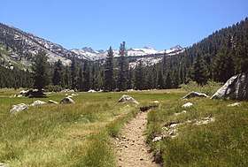
Lyell Canyon is a sub-alpine meadow in Yosemite National Park south of Tuolumne Meadows. For 13 kilometers (8 statute miles) most of the canyon has an approximate elevation of 2 700 meters (8,850 feet), and then rapidly climbs to 3 370 meters (11,056 feet) to Donohue Pass, below Donohue Peak – which marks the eastern boundary of Yosemite. The valley at the base is relatively flat and wide, following the Lyell Fork of the Tuolumne River through an open meadow and wooded areas. The Lyell Fork eventually meets with Tuolumne River.[1]
| Lyell Canyon | |
|---|---|
 Looking down into Lyell Canyon from the John Muir trail | |
| Floor elevation | 8,850 feet (2,700 m) |
| Length | 8 miles (13 km) |
| Geography | |
| Coordinates | 37°51′50.736″N 119°18′6.55″W |
The canyon as well as Mount Lyell to the west is named after Charles Lyell, a well-known 19th century geologist and friend of Charles Darwin.
The canyon is an easy hike from Tuolumne Meadows campground. The John Muir Trail and the Pacific Crest Trail both route through the canyon.[2] The trail is popular for hikers as an easy way to view surrounding mountains, a waterfall and Sierra wildflowers.
External links
See also
References
- Cary, Russ. "Lyell Canyon". Yosemite Hikes. Retrieved July 22, 2014.
- "John Muir Trail: Yosemite National Park Section". hikejmt.com. Retrieved July 22, 2014.