Lompnieu
Lompnieu is a former commune in the Ain department in eastern France. On 1 January 2019, it was merged into the new commune Valromey-sur-Séran.[2]
Lompnieu | |
|---|---|
Part of Valromey-sur-Séran | |
 | |
Location of Lompnieu 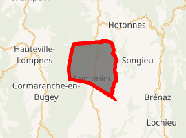
| |
 Lompnieu  Lompnieu | |
| Coordinates: 45°57′42″N 5°39′39″E | |
| Country | France |
| Region | Auvergne-Rhône-Alpes |
| Department | Ain |
| Arrondissement | Belley |
| Canton | Hauteville-Lompnes |
| Commune | Valromey-sur-Séran |
| Area 1 | 11.35 km2 (4.38 sq mi) |
| Population (2017-01-01)[1] | 117 |
| • Density | 10/km2 (27/sq mi) |
| Time zone | UTC+01:00 (CET) |
| • Summer (DST) | UTC+02:00 (CEST) |
| Postal code | 01260 |
| Elevation | 524–1,241 m (1,719–4,072 ft) (avg. 650 m or 2,130 ft) |
| 1 French Land Register data, which excludes lakes, ponds, glaciers > 1 km2 (0.386 sq mi or 247 acres) and river estuaries. | |
It is located in La Val Romey, which means, "The Roman Valley." The Romans built several outposts in the valley.
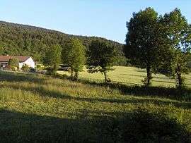
Lompnieu is located near the base of the large valley, with forest mounting on one side, and a plain with larger mountains looming on the other side. On a clear day, the snow-covered Alps can be seen. Lompnieu is around 600 metres in elevation. The climate is rather hot in the summer, attaining into the 1990s, and fairly cold in winter, with several large snow falls.
Population
| Historical population | ||
|---|---|---|
| Year | Pop. | ±% |
| 2004 | 97 | — |
| 2006 | 96 | −1.0% |
| 2007 | 103 | +7.3% |
| 2008 | 111 | +7.8% |
| 2009 | 118 | +6.3% |
| 2010 | 122 | +3.4% |
| 2011 | 125 | +2.5% |
| 2012 | 122 | −2.4% |
| 2013 | 118 | −3.3% |
| 2014 | 115 | −2.5% |
| 2015 | 113 | −1.7% |
| 2016 | 113 | +0.0% |

See also
References
- "Populations légales 2017". INSEE. Retrieved 6 January 2020.
- Arrêté préfectoral 17 December 2018 (in French)
| Wikimedia Commons has media related to Lompnieu. |
This article is issued from Wikipedia. The text is licensed under Creative Commons - Attribution - Sharealike. Additional terms may apply for the media files.