Loch Shurrery
Loch Shurrery (also known as Loch Shurrey) is a small, shallow, lowland freshwater loch lying approximately 8 mi (13 km) south west of Thurso in the Scottish Highlands. The loch has a somewhat elliptical shape with a perimeter of 7.4 km (4.6 mi). It is approximately 1.25 mi (2.01 km) long, has an average depth of 4.5 ft (1.4 m) and is 7 ft (2.1 m) at its deepest. The loch was surveyed[3] on 6 October 1902 by John Parsons and T.R.H. Garrett and later charted[4] as part of Sir John Murray's Bathymetrical Survey of Fresh-Water Lochs of Scotland 1897-1909. A dam lies to the north end of the loch.
| Loch Shurrery | |
|---|---|
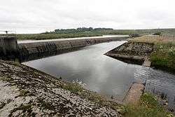 Dam at the head of Loch Shurrery | |
| Location | Caithness, Highlands Scotland |
| Coordinates | 58.477600°N 3.640100°W[1] |
| Type | freshwater loch |
| Primary inflows | Torran Water[2] |
| Primary outflows | Forss Water[2] |
| Basin countries | Scotland |
| Max. length | 1.25 mi (2.01 km)[3] |
| Max. width | 0.5 mi (0.80 km)[3] |
| Surface area | 99.4 ha (246 acres)[1] |
| Average depth | 4.5 ft (1.4 m)[3] |
| Max. depth | 7 ft (2.1 m)[3] |
| Water volume | 43,000,000 cu ft (1,200,000 m3)[3] |
| Shore length1 | 7.4 km (4.6 mi)[1] |
| Surface elevation | 94 m (308 ft)[1] |
| Islands | 1[1] |
| 1 Shore length is not a well-defined measure. | |
Approximately 200 yards (180 m) from the northern end of the loch are the archaeological remains of an Iron Age hut circle with a medium-sized oval house. Some pottery was found at the site.[5] At the southern end of the loch is Lambsdale Leans, a cairn with possible cist or chamber. Two Viking graves lie nearby.[6]
The loch is used for fishing and the Dounreay Fly Fishing Association keeps a boat on the loch for members and visitors.[7]
References
- "Loch Shurrey". British lakes. British Lakes. Retrieved 18 June 2016.
- "Sheet 11 - Thurso & Reay". National Library of Scotland. Ordnance Survey. 1931. Retrieved 18 June 2016.
- "Bathymetrical Survey of the Fresh-Water Lochs of Scotland, 1897-1909, Lochs of the Forss Basin". National Library of Scotland. Retrieved 18 June 2016.
- "Loch Calder; Loch Shurrery (Vol. 5, Plate 7), Bathymetrical Survey, 1897-1909". National Library of Scotland. Retrieved 12 June 2016.
- MacLaren, Alistair (1955). "Later Prehistoric house and Early Medieval buildings in Northern Scotland: Excavations at Loch Shurrery and Lambsdale Leans, Caithness, 1955" (PDF). Archaeology Data Service. Retrieved 2016-06-18.
- "Lambsdale". Canmore. Retrieved 2016-06-18.
- "Loch Shurrery". Dounreay Fly Fishing Association.