Loch Lundie
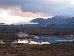
Loch Lundie is a small, lowland freshwater loch in Glen Garry, about 1.5 miles (2.4 km) north-west of Invergarry in the Scottish Highlands. The loch is irregular in shape with a perimeter of 0.9 km (0.56 mi). It is approximately 0.75 mi (1.21 km) long, has an average depth of 40 ft (12 m) and is 54 ft (16 m) at its deepest. The loch was surveyed[2] in 1903 by Sir John Murray and James Murray[3] as part of the Bathymetrical Survey of Fresh-Water Lochs of Scotland 1897-1909.
| Loch Lundie | |
|---|---|
 Loch Lundie | |
| Location | Highlands, Scotland |
| Coordinates | 57.091500°N 4.814000°W[1] |
| Type | freshwater loch |
| Primary inflows | Allt Lundie[2] |
| Primary outflows | Aldernaig Burn[2] |
| Basin countries | Scotland |
| Max. length | 0.75 mi (1.21 km)[2] |
| Max. width | 0.33 mi (0.53 km)[2] |
| Surface area | 44.1 ha (109 acres)[1] |
| Average depth | 40 ft (12 m)[2] |
| Max. depth | 54 ft (16 m)[2] |
| Water volume | 78,000,000 cu ft (2,200,000 m3)[2] |
| Shore length1 | 5.5 km (3.4 mi)[1] |
| Surface elevation | 137 m (449 ft)[1] |
| Islands | 2[1] |
| 1 Shore length is not a well-defined measure. | |
References
- "Loch Lundie, Highland". British lakes. British Lakes. Retrieved 25 June 2016.
- "Bathymetrical Survey of the Fresh-Water Lochs of Scotland, 1897-1909, Lochs of the Ness Basin". National Library of Scotland. Retrieved 25 June 2016.
- "Lochs Lundie & a' Bhainne (Vol. 4, Plate 96 - Mylar sheet 21)". National Library of Scotland. Retrieved 25 June 2016.
This article is issued from Wikipedia. The text is licensed under Creative Commons - Attribution - Sharealike. Additional terms may apply for the media files.