Loch Achanalt
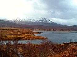
Loch Achanalt is a small, irregularly shaped, lowland freshwater loch in Ross and Cromarty in the Scottish Highlands, close to Achanalt railway station and the village of Achanalt. It is roughly quadrangular in shape with an approximate diameter of 1.21 km (0.75 mi), and is at an altitude of 112 m (367 ft). The average depth is 1.37 m (4 ft 6 in) and its maximum depth is 2.75 m (9 ft 0 in). The River Bran flows into the loch on its western shore, and at its eastern shore there is a short fast stream draining into Loch a' Chuilinn. The loch was surveyed on 9 August 1902 by R.M. Clarke and James Murray as part of Sir John Murray's Bathymetrical Survey of Fresh-Water Lochs of Scotland 1897–1909.[1][3][4]
| Loch Achanalt | |
|---|---|
 | |
| Location | Ross and Cromarty, Highlands, Scotland |
| Coordinates | 57.6083°N 4.8932°W[1] |
| Type | Freshwater |
| Primary inflows | River Bran[2] |
| Basin countries | Scotland |
| Max. length | 1.21 km (0.75 mi)[3] |
| Max. width | 1.21 km (0.75 mi)[3] |
| Surface area | 19.7 ha (49 acres)[1] |
| Average depth | 1.37 m (4.5 ft)[3] |
| Max. depth | 2.75 m (9.0 ft)[3] |
| Water volume | 877,822 m3 (31,000,000 cu ft)[3] |
| Shore length1 | 2.3 km (1.4 mi)[1] |
| Surface elevation | 112 m (367 ft)[1] |
| 1 Shore length is not a well-defined measure. | |
The Loch-class frigate HMS Loch Achanalt was named after the loch.[5]
References
- "Loch Achanalt". British Lakes. Retrieved 2017-09-27.
- "Ordnance Survey one-inch Scotland, 1885–1900". National Library of Scotland. Retrieved 2017-09-27.
- "Lochs of the Conon Basin". National Library of Scotland. Retrieved 2017-09-27.
- "Lochs Achanalt & a' Chuilinn; Loch Beannachan (Vol. 4, Plate 58)". National Library of Scotland. Retrieved 2017-09-16.
- "HMS Loch Achanalt, later HMNZS Pukaki". www.naval-history.net. Retrieved 2017-09-27.