Listed buildings in Whitwell and Selside
Whitwell and Selside is a civil parish in the South Lakeland District of Cumbria, England. It contains eleven listed buildings that are recorded in the National Heritage List for England. Of these, one is listed at Grade II*, the middle of the three grades, and the others are at Grade II, the lowest grade. The parish contains the village of Selside and smaller settlements, and is otherwise rural. The listed buildings consist of houses, farm buildings, bridges, mileposts, and a church.
Key
| Grade | Criteria[1] |
|---|---|
| II* | Particularly important buildings of more than special interest |
| II | Buildings of national importance and special interest |
Buildings
| Name and location | Photograph | Date | Notes | Grade |
|---|---|---|---|---|
| Selside Hall and outbuilding 54.38476°N 2.71813°W |
— |
Late 14th century | The house was later altered and extended. It is in roughcast stone with ashlar dressings and slate roofs. The house has an L-shaped plan and is mainly in two storeys. The east front has five bays, the outer bays projecting and gabled, and it contains a gabled porch with pointed openings. The south wing has thick walls and four bays. To the north is a single-storey extension with a projecting wing. The windows vary; some are mullioned, some are casements, and others are sashes. Inside the house is an inglenook and a bressumer.[2][3] | II* |
| Brackenrigg Side and barn 54.38311°N 2.70925°W |
— |
1674 | The house and barn are in stone with a slate roof. The house has two storeys and three bays, and the barn is attached to the left. On the front of the house is a gabled porch, and the windows are casements. The barn has various entrances and windows.[4] | II |
| Watchgate 54.38493°N 2.72787°W |
— |
Early 18th century (probable) | The rear wing was added in the 19th century. The house is in roughcast stone with a slate roof, and quoins in the rear wing. There are two storeys and a south front of three bays. On the front is a gabled porch and sash windows, those in the ground floor having hood moulds. The windows in the rear wing are casements.[5] | II |
| Browfoot Barn 54.37521°N 2.70276°W |
— |
Early to mid 18th century (probable) | A bank barn in stone with quoins and a Cumberland slate roof. There are two storeys, a main range of three bays, and a two-bay wing, giving an L-shaped plan. In the south front is a porch and wagon entrance with a segmental head and voussoirs, and elsewhere are other doorways.[6] | II |
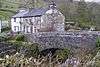
| Bannisdale High Bridge 54.40387°N 2.70847°W |
 |
18th century (probable) | The bridge carries a road, originally the Heron Syke to Eamont Bridge turnpike road, over Bannisdale Beck. It is in stone and consists of a single segmental arch with a roadway 8 metres (26 ft) wide. The bridge has irregular voussoirs, and parapets with dressed coping.[7] | II |
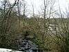
| Garnett Bridge 54.38660°N 2.73501°W |
 |
18th century | The bridge carries a narrow road over the River Sprint. It is in limestone and consists of a single arch over a natural gorge.[8] | II |
| Bannisdale Low Bridge 54.40341°N 2.70602°W |
— |
1820s | The bridge carries the A6 road over Bannisdale Beck. It is in stone and consists of a single round arch with flanking piers. The bridge has a band, coped parapets, and abutments on the west side that curve forward. The roadway is about 9 metres (30 ft) wide.[9] | II |
| Milepost opposite Memorial Hall 54.39840°N 2.70955°W |
 |
1825 | The milepost was provided for the Heron Syke to Eamont Bridge turnpike road. It is in cast iron, and is half-hexagonal with concave faces and a domed top. The panels are inscribed with the distances in miles to Shap and to Kendal.[10] | II |
| Milepost near North Gateside 54.38897°N 2.72738°W |
— |
1825 | The milepost was provided for the Heron Syke to Eamont Bridge turnpike road. It is in cast iron, and is half-hexagonal with concave faces and a domed top. The panels are inscribed with the distances in miles to Shap and to Kendal.[11] | II |
| St Thomas' Church 54.38623°N 2.71675°W |
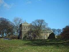 |
1838 | The church was rebuilt on the site of an earlier church. In 1894 it was restored by C. J. Ferguson, and the tower was added. The church is in stone, the body roughcast, and the roof slated. It consists of a nave, a porch, a north organ loft, and a west tower. The tower has bands, an embattled parapet, a squat pyramidal roof with a weathervane, and a stair turret at the south. The porch is gabled and has a Tudor arched doorway, and the windows are lancets.[2][12] | II |
| Outbuilding, Selside Hall 54.38468°N 2.71786°W |
— |
19th century (probable) | The outbuilding is in stone with a slate roof and three bays. The first two bays have pigstys in the ground floor and hen houses above. The third bay projects and contains an entrance. On the north side are steps leading to an upper floor doorway.[2][13] | II |
References
Citations
- Historic England
- Hyde & Pevsner (2010), p. 613
- Historic England & 1311671
- Historic England & 1335922
- Historic England & 1158031
- Historic England & 1158094
- Historic England & 1086906
- Historic England & 1213112
- Historic England & 1137606
- Historic England & 1311663
- Historic England & 1335942
- Historic England & 1311692
- Historic England & 1086834
Sources
- Historic England, "Selside Hall and attached outbuilding, Whitwell and Selside (1311671)", National Heritage List for England, retrieved 19 May 2017
- Historic England, "Brackenrigg Side and attached barn, Whitwell and Selside (1335922)", National Heritage List for England, retrieved 19 May 2017
- Historic England, "Watchgate, Whitwell and Selside (1158031)", National Heritage List for England, retrieved 19 May 2017
- Historic England, "Browfoot Barn to rear of Darlfield House, Whitwell and Selside (1158094)", National Heritage List for England, retrieved 19 May 2017
- Historic England, "Bannisdale High Bridge, Whitwell and Selside (1086906)", National Heritage List for England, retrieved 19 May 2017
- Historic England, "Garnett Bridge over the River Sprint, Whitwell and Selside (1213112)", National Heritage List for England, retrieved 19 May 2017
- Historic England, "Bannisdale Low Bridge, Whitwell and Selside (1137606)", National Heritage List for England, retrieved 19 May 2017
- Historic England, "Milepost opposite Memorial Hall, Whitwell and Selside (1311663)", National Heritage List for England, retrieved 19 May 2017
- Historic England, "Milepost to west of North Gateside, Whitwell and Selside (1335942)", National Heritage List for England, retrieved 19 May 2017
- Historic England, "Church of St Thomas, Whitwell and Selside (1311692)", National Heritage List for England, retrieved 19 May 2017
- Historic England, "Outbuilding immediately to south-east of Selside Hall, Whitwell and Selside (1086834)", National Heritage List for England, retrieved 19 May 2017
- Historic England, Listed Buildings, retrieved 19 May 2017
- Hyde, Matthew; Pevsner, Nikolaus (2010) [1967], Cumbria, The Buildings of England, New Haven and London: Yale University Press, ISBN 978-0-300-12663-1
This article is issued from Wikipedia. The text is licensed under Creative Commons - Attribution - Sharealike. Additional terms may apply for the media files.