Listed buildings in Skelsmergh
Skelsmergh is a former civil parish now in the parish of Skelsmergh and Scalthwaiterigg, in the South Lakeland district of Cumbria, England. It contained five listed buildings that are recorded in the National Heritage List for England. All the listed buildings are designated at Grade II, the lowest of the three grades, which is applied to "buildings of national importance and special interest".[1] The parish contained the village of Skelsmergh, and was otherwise rural. The listed buildings consist of two houses with associated structures, a chapel, and two milestones.
Buildings
| Name and location | Photograph | Date | Notes |
|---|---|---|---|
| Skelsmergh Hall 54.35654°N 2.72213°W |
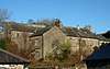 |
15th century | Two houses and an outbuilding that originated as a pele tower, with extensions in the 16th and 17th centuries. The building is in stone, partly roughcast, and has slate roofs. The tower, now an outbuilding, has three storeys, and is gabled on two sides. The 17th-century range has mullioned and transomed windows, and there is also a garderobe with slit windows.[2][3] |
| Burton House, barn and outbuilding 54.36133°N 2.72728°W |
— |
17th century (probable) | The building is in stone with slate roofs. The house has two storeys and two bays, a gabled porch with rounded angles, and casement windows. To the south is a barn with a ramp leading up to the entrance, a gabled wing to the west, and an outshut to the east. To the north is an outbuilding with a doorway, a window, and a loading door.[4] |
| Chapel of SS Robert and Alice and Presbytery 54.35167°N 2.71965°W |
— |
Mid to late 17th century | Originally an H-shaped house, it was left to the Roman Catholic church in 1723, and converted into a chapel. It is in roughcast stone with a slate roof. The building has two storeys, an east front of three bays, and a south front of two bays. Most of the windows are sashes, there are some casement windows, and there is a gabled porch with a segmental-headed entrance.[2][5] |
| Milepost near Stocks Mill 54.36500°N 2.72525°W |
— |
1825 | The milepost is on the west side of the A6 road, and is in cast iron. It was provided for the Heron Syke to Eamont Bridge turnpike road. The milepost is half-hexagonal and has fluted faces and a domed cap. It is inscribed with the distances in miles to Shap and to Kendal.[6] |
| Milepost at SD 524 980 54.37578°N 2.73420°W |
— |
1825 | The milepost is on the west side of the A6 road, and is in cast iron. It was provided for the Heron Syke to Eamont Bridge turnpike road. The milepost is half-hexagonal and has fluted faces and a domed cap. It is inscribed with the distances in miles to Shap and to Kendal.[7] |
References
Citations
Sources
- Historic England, "Skelsmergh Hall, Skelsmergh (1086869)", National Heritage List for England, retrieved 7 May 2017
- Historic England, "Burton House and attached barn and outbuilding, Skelsmergh (1086870)", National Heritage List for England, retrieved 7 May 2017
- Historic England, "Catholic Chapel of SS Robert and Alice and Presbytery, Dodding Green, Skelsmergh (1157927)", National Heritage List for England, retrieved 7 May 2017
- Historic England, "Milepost approximately 100 metres to north of Stocks Mill, Skelsmergh (1157917)", National Heritage List for England, retrieved 7 May 2017
- Historic England, "Milepost at SD 524 980, Skelsmergh (1335919)", National Heritage List for England, retrieved 7 May 2017
- Historic England, Listed Buildings, retrieved 7 May 2017
- Hyde, Matthew; Pevsner, Nikolaus (2010) [1967], Cumbria, The Buildings of England, New Haven and London: Yale University Press, ISBN 978-0-300-12663-1
This article is issued from Wikipedia. The text is licensed under Creative Commons - Attribution - Sharealike. Additional terms may apply for the media files.