Listed buildings in Fawcett Forest
Fawcett Forest is a civil parish in the South Lakeland District of Cumbria, England. It contains twelve listed buildings that are recorded in the National Heritage List for England. All the listed buildings are designated at Grade II, the lowest of the three grades, which is applied to "buildings of national importance and special interest". [1] The parish is in the Lake District National Park, and is sparsely populated, containing no settlements of significant size. Six of the listed buildings are bridges, and the others are farmhouses, farm buildings, and mileposts.
Buildings
| Name and location | Photograph | Date | Notes |
|---|---|---|---|
| Borrowdale Head Farmhouse and barn 54.43040°N 2.70453°W |
— |
17th century (probable) | The farmhouse and barn are in stone with a slate roof. The house has two storeys and two bays. On the front is a gabled porch, the windows in the ground floor are sashes, and in the upper floor they are casements. In the east front of the barn are five small openings, a blocked entrance and a winnowing door, and on the north side is the entrance to a cow shed. On the west side is an outshut, an outhouse, and a ramp leading up to an entrance.[2][3] |
| Barn, Bannisdale Head 54.43157°N 2.74921°W |
— |
17th century (probable) | The barn is in stone with a slate roof. It has a barn entrance and various smaller entrances, and on the east side is a later outshut. Inside is a cruck truss.[4] |
| Bannisdale Head 54.43145°N 2.74905°W |
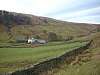 |
Mid to late 17th century | A south wing was added to the house in the 19th century. The house is in roughcast stone with a slate roof and two storeys. The original range has three bays, the third bay projecting forward under a gable. There is a central gabled porch, the ground floor windows have segmental heads, there is a hood mould above them, and the upper floor windows have flat heads. The south wing has two bays, tall casement windows, and a gabled porch.[5] |
| Bannisdale High Bridge 54.40387°N 2.70847°W |
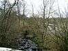 |
18th century (probable) | The bridge carries a road, originally the Heron Syke to Eamont Bridge turnpike road, over Bannisdale Beck. It is in stone and consists of a single segmental arch with a roadway 8 metres (26 ft) wide. The bridge has irregular voussoirs, and parapets with dressed coping.[6] |
| Borrowdale Head Bridge 54.43059°N 2.70366°W |
— |
18th century (probable) | The bridge carries a track over Borrow Beck. It is in stone, it consists of a single segmental arch with voussoirs, and is about 2.5 metres (8 ft 2 in) wide. There are iron railings, but no parapets.[7] |
| Crookdale Bridge 54.44335°N 2.69508°W |
— |
18th century (probable) | The bridge carries a road over Crookdale Beck. It is in stone and consists of a single segmental arch. The bridge has thin voussoirs, low parapets, and is about 3.5 metres (11 ft) wide. It was on the route of the Heron Syke to Eamont Bridge turnpike road.[8] |
| Crookdale Low Bridge 54.43111°N 2.69276°W |
— |
18th century (probable) | The bridge carries a track over Crookdale Beck. It is in stone and consists of a single segmental arch. The bridge has thin voussoirs, low parapets, and is about 3.5 metres (11 ft) wide.[9] |
| High Borrow Bridge 54.42983°N 2.69508°W |
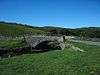 |
18th century (probable) | The bridge carries a road over Borrow Beck, it is in stone and consists of a single segmental arch. The bridge has thin voussoirs, a plain parapet with upright stones forming coping, and is about 3.5 metres (11 ft) wide. It was on the route of the Heron Syke to Eamont Bridge turnpike road.[10] |
| Outbuilding, Borrowdale Head Farm 54.43043°N 2.70433°W |
— |
18th or 19th century (probable) | A small stone building with a slate roof, two storeys, and a north lean-to. On the west side is a gable and an entrance with a canopy, in the south wall is a small window, and on the east side are external steps leading up to an entrance.[11] |
| Milepost 54.43215°N 2.69113°W |
— |
1825 | The milepost was provided for the Heron Syke to Eamont Bridge turnpike road, now the A6 road. It is in cast iron and has a half hexagonal plan with fluted faces and a domed cap. The date is on the front face, and the other faces are inscribed with the distances in miles to Shap and to Kendal.[12] |
| Milepost 54.40742°N 2.69481°W |
— |
1825 | The milepost was provided for the Heron Syke to Eamont Bridge turnpike road, now the A6 road. It is in cast iron and has a half hexagonal plan with fluted faces and a domed cap. The date is on the front face, and the other faces are inscribed with the distances in miles to Shap and to Kendal.[13] |
| Huck's Bridge 54.42904°N 2.69110°W |
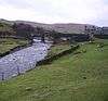 |
1826 | The bridge carries the A6 road over Crookdale Beck. It is in stone, and consists of two round arches, the piers having triangular cutwaters. The bridge has plain parapets, a band on the east side, and raking abutments. Originally about 9 metres (30 ft) wide, it has been widened to about 15.5 metres (51 ft).[14] |
References
Citations
- Historic England
- Hyde & Pevsner (2010), pp. 346–347
- Historic England & 1137635
- Historic England & 1312218
- Historic England & 1086905
- Historic England & 1086906
- Historic England & 1086908
- Historic England & 1335937
- Historic England & 1312197
- Historic England & 1137653
- Historic England & 1086907
- Historic England & 1086903
- Historic England & 1086904
- Historic England & 1312241
Sources
- Historic England, "Borrowdale Head Farmhouse and attached barn, Fawcett Forest (1137635)", National Heritage List for England, retrieved 15 February 2017
- Historic England, "Barn to north end of Bannisdale Head, Fawcett Forest (1312218)", National Heritage List for England, retrieved 15 February 2017
- Historic England, "Bannisdale Head, Fawcett Forest (1086905)", National Heritage List for England, retrieved 15 February 2017
- Historic England, "Bannisdale High Bridge, Fawcett Forest (1086906)", National Heritage List for England, retrieved 15 February 2017
- Historic England, "Borrowdale Head Bridge, Fawcett Forest (1086908)", National Heritage List for England, retrieved 15 February 2017
- Historic England, "Crookdale Bridge, Fawcett Forest (1335937)", National Heritage List for England, retrieved 15 February 2017
- Historic England, "Crookdale Low Bridge, Fawcett Forest (1312197)", National Heritage List for England, retrieved 15 February 2017
- Historic England, "High Borrow Bridge, Fawcett Forest (1137653)", National Heritage List for England, retrieved 15 February 2017
- Historic England, "Outbuilding to south-west of Borrowdale Head Farmhouse, Fawcett Forest (1086907)", National Heritage List for England, retrieved 15 February 2017
- Historic England, "Milepost at NY 552 042, Fawcett Forest (1086903)", National Heritage List for England, retrieved 15 February 2017
- Historic England, "Milepost approximately 330 metres to north-east of Forest Hall, Fawcett Forest (1086904)", National Heritage List for England, retrieved 15 February 2017
- Historic England, "Huck's Bridge, Fawcett Forest (1312241)", National Heritage List for England, retrieved 15 February 2017
- Historic England, Listed Buildings, retrieved 15 February 2017
- Hyde, Matthew; Pevsner, Nikolaus (2010) [1967], Cumbria, The Buildings of England, New Haven and London: Yale University Press, ISBN 978-0-300-12663-1
This article is issued from Wikipedia. The text is licensed under Creative Commons - Attribution - Sharealike. Additional terms may apply for the media files.