List of smallest cities in the United Kingdom
This list displays the official cities in the United Kingdom with a population of less than 100,000 since the 2001 census.
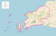
Map of St. Davids in Pembrokeshire, Wales, demonstrating the size of the settlement, compared to its wider community boundary. Also indicated are isolated hamlets within the city.
City boundaries
Built-up area
For the list of all cities, and with additional information, see List of cities in the United Kingdom.
Lichfield, Hereford and Salisbury, in addition to being some of the smallest cities in England, are among the most populous civil parishes.
| # | City | Census Population1 | Home Nation | County | Area (sq mi)2 | Area (sq km)2 | Locale/ Body% | |||
|---|---|---|---|---|---|---|---|---|---|---|
| 2001 | 2011 | Body3 | Locale4 | Body3 | Locale4 | |||||
| 1 | St Davids | 1,797[1] | 1,841 | Wales | Pembrokeshire | 17.88 | 0.23 | 46.30 | 0.595 | 1.29% |
| 2 | St Asaph | 3,491 | 3,355 | Wales | Denbighshire | 2.49 | 0.50 | 6.44 | 1.30 | 20.19% |
| 3 | City of London | 7,185[2] | 8,072 | England | City of London | 1.12 | 1.12 | 2.90 | 2.90 | 100.00% |
| 4 | Wells | 10,406[3] | 10,536 | England | Somerset | 2.11 | 1.35 | 5.47 | 3.50 | 63.99% |
| 5 | Armagh | 14,590 | 14,749 | Northern Ireland | County Armagh | — | 3.97 | — | 10.29 | — |
| 6 | Bangor | 13,725[4] | 16,358[5] | Wales | Gwynedd | 2.79 | 1.65 | 7.23 | 4.28 | 59.20% |
| 7 | Ripon | 15,922[6] | 16,702[7] | England | North Yorkshire | 3.83 | 1.97 | 9.93 | 5.10 | 51.36% |
| 8 | Truro | 17,431[8] | 18,766 | England | Cornwall | 4.15 | 2.83 | 10.74 | 7.33 | 68.25% |
| 9 | Ely | 15,102[9] | 20,256 | England | Cambridgeshire | 22.86 | 1.84 | 59.21 | 4.76 | 8.04% |
| 10 | Chichester | 23,731[10] | 26,795 | England | West Sussex | 4.12 | 3.32 | 10.66 | 8.61 | 80.77% |
| 11 | Newry | 27,433 | 26,967 | Northern Ireland | County Armagh & County Down |
— | 5.43 | — | 14.06 | — |
| 12 | Lichfield | 27,900[11] | 32,219 | England | Staffordshire | 5.41 | 3.35 | 14.02 | 8.67 | 61.84% |
| 13 | Salisbury | 39,726[12][13] | 40,302 | England | Wiltshire | 7.14 | 4.36 | 18.48 | 11.28 | 61.04% |
| 14 | Lisburn | 71,465 | 45,370[14] | Northern Ireland | County Antrim & County Down |
— | 7.53 | — | 19.51 | — |
| 15 | Stirling | 45,115 | 45,750 | Scotland | Stirling | — | 7.91 | — | 20.48 | — |
| 16 | Perth | 43,450 | 46,970[15] | Scotland | Perth & Kinross | — | 6.71 | — | 17.38 | — |
| 17 | Hereford | 50,154[16] | 58,896[17] | England | Herefordshire | 7.85 | 6.58 | 20.34 | 17.05 | 83.82% |
| 18 | Inverness | 71,000 | 61,235[18][19] | Scotland | Highland | — | 10.28 | — | 26.63 | — |
| 19 | Chester | 77,040[20] | 79,645[21] | England | Cheshire | 448.045 | 9.85 | 1,160.425 | 25.52 | — |
| 20 | Derry | 83,652 | 85,016 | Northern Ireland | County Londonderry | — | 13.10 | — | 33.94 | — |
| 21 | Bath | 83,992[22] | 88,859 | England | Somerset | 28.685 | 11.07 | 74.285 | 28.67 | — |
| 22 | Lincoln | 85,595[23] | 93,541 | England | Lincolnshire | 13.78 | 12.61 | 35.69 | 32.65 | 91.48% |
| 23 | Durham | 87,709[24] | 94,375 | England | County Durham | 186.685 | 4.96 | 483.505 | 12.86 | — |
| 24 | Worcester | 93,353[25] | 97,700[26] | England | Worcestershire | 12.85 | 9.52 | 33.27 | 24.66 | 74.12% |
Notes
- ^1 Population is usually of the lowest level local council body most closely covering the urban extent of the settlement (see note3). For cities without a direct public entity such as in an unparished area, the population is instead compiled from an agglomeration of electoral wards which cover its urban area (see note4) or prior district area (see note5). Several districts presently hold city status, and are named after their largest town - these have populations over 100,000 and so are not listed here, although the town will typically have a smaller population than this.
- ^2 Sources:
- England and Wales area figures are taken from the ONS Geography Linked Data, DEFRA, AND NOMIS sites.
- Scotland cities post-2000 area and population figures are taken from the Scotland Census site and settlement size used as local government areas there are not required to hold the city designation for their full area[27]
- Northern Ireland (NI) area and population figures taken from the NISRA site. The cities there formed their own districts until local authority reform in 2015. These settlements now form part of larger council areas, but kept their city statuses through continuing legislation.
- ^3 The area (body) measurement is the size of a localised council area holder of the city designation, if there is one. See the table in the List of cities in the United Kingdom for the local government status of these bodies. These council area borders are well-defined, and cities are typically awarded the honour via parish or principal governing public bodies, so it is used as a primary sizing definition. Most in the table are parishes (England) or communities (Wales), except for the City of London (county), Lincoln and Worcester (districts). In Scotland and NI (see note2), wider council areas can hold the title on behalf of a city urban area so the area (body) does not apply.
- ^4 The area (locale) reflects the built up area that most closely covers the urban size of the named city settlement. It is listed as a comparator figure to the public body measurement given. It is used in lieu of the body size where there is no local government entity, e.g. unparished area with city charter trustees (see note5), or cities designated by their urban area (Scotland, NI). This is a secondary method of determining physical size; relatively fewer cities are explicitly defined by this, and their urban area can extend beyond the city boundary.
- ^5 Cities with charter trustees covering previous local government areas (England):
- Bath - the city area considered is the present-day 16 electoral wards covering the size of the former borough, in existence until 1996.
- Chester - area held is the prior City of Chester district active until 2009, population of wards in 2001 was 118,210, wards not directly mappable in 2011 so local population figures given in table.
- Durham - this was parished in 2018, but city charter trustees continue to exist, and so hold the charter on behalf of the city area covered by the much wider Durham city district council until 2009, 2011 population is of wards covering the same area. The title is not held by the parish council.[28][29][30] Size of the parish is 5.56 sq mi (14.40 km2) and its population 20,115 (2011).[31][32]
References
- Census 2001 : Pembrokeshire
- Census 2001 : City of London
- Census 2001 : Mendip
- Census 2001 : Gwynedd Archived 2010-09-22 at the Wayback Machine
- "Custom report - Nomis - Official Labour Market Statistics". www.nomisweb.co.uk. Retrieved 2018-10-21.
- Census 2001 : Harrogate
- "Custom report - Nomis - Official Labour Market Statistics". www.nomisweb.co.uk. Retrieved 2018-10-21.
- Census 2001 : Carrick
- Census 2001 : East Cambridgeshire
- Census 2001 : Chichester
- Census 2001 : Lichfield
- Census 2001 : Salisbury (Former Local Authority)
- Census 2001 : Salisbury
- "Key Statistics" (PDF). www.niassembly.gov.uk.
- "Perth & Kinross Council - Census 2011 (3 Perth wards)". www.pkc.gov.uk. Retrieved 2017-04-02.
- Census 2001 : Herefordshire
- "2011 CENSUS KEY STATISTICS - Hereford City" (PDF). factsandfigures.herefordshire.gov.uk/about-your-area/2011-census-market-town-profiles.aspx.
- Butlin, Heather. "Highland profile - key facts and figures". www.highland.gov.uk. Retrieved 2017-04-02.
- Council, The Highland. "The Highland Council download - Briefing notes | Planning and building standards | Planning - policies, advice and service levels". www.highland.gov.uk. Retrieved 2017-04-02.
- "Demographics" (PDF). Cheshire County Council. Archived from the original (PDF) on June 26, 2008. Retrieved 27 September 2008.
- "Locality Chester People and Population Profile Census 2011". inside.cheshirewestandchester.gov.uk.
- Bathnes.gov.uk Archived 2007-12-20 at the Wayback Machine, Bath and North East Somerset District Council: Population Statistics
- Office for National Statistics : Census 2001 : Key Statistics : City of Lincoln Retrieved 2009-11-22
- Census 2001 : Durham
- Census 2001 : Worcester
- Lemon, Sarah. "Population Statistics". www.worcestershire.gov.uk. Archived from the original on 2017-04-03. Retrieved 2017-04-02.
- "Department for Culture Media and Sport - civic honours competitions". old.culture.gov.uk. Archived from the original on 2016-04-28. Retrieved 2017-05-02.
Applications can only be made in respect of the whole of the local authority area, except in Scotland, where the award of city status operates differently because of differences in the legislation underpinning local government.
- "What you need to know about a new parish council for Durham city centre". The Northern Echo.
- "Review of Community Governance in the Unparished Area of Durham City carried out by Durham County Council Final Recommendations (No Parishing Arrangements)" (PDF). www.durham.gov.uk.
- "Review of Community Governance in the Central Unparished areas of Durham by Durham County Council" (PDF). www.durham.gov.uk.
- Elvet Ward. "Custom report - Nomis - Official Labour Market Statistics". www.nomisweb.co.uk. Retrieved 2018-10-21.
- Neville's Cross Ward. "Custom report - Nomis - Official Labour Market Statistics". www.nomisweb.co.uk. Retrieved 2018-10-21.
This article is issued from Wikipedia. The text is licensed under Creative Commons - Attribution - Sharealike. Additional terms may apply for the media files.