List of protected heritage sites in Thuin
This table shows an overview of the protected heritage sites in the Walloon town Thuin. This list is part of Belgium's national heritage.
| Object |
Year/architect |
Town/section |
Address |
Coordinates |
Number? |
Image |
|---|---|---|---|---|---|---|
| Thuin Belfry (nl) (fr) |
Thuin | rue Albert Ier | 50.339645°N 4.286605°E |
56078-CLT-0001-01 Info |
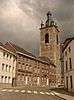 Belfort van Thuin | |
| House "espagnole": facade (nl) (fr) |
Thuin | Grand-Rue n°21 | 50.339016°N 4.288350°E |
56078-CLT-0004-01 Info |
Huis "espagnole": gevel | |
| Cloister Chapel of the Grey Nuns (nl) (fr) |
Thuin | Thuin | 50.338835°N 4.291392°E |
56078-CLT-0005-01 Info |
||
| "Jardins suspendus"- hanging garders of Thuin (nl) (fr) |
Thuin | Thuin | 50.338295°N 4.290162°E |
56078-CLT-0006-01 Info |
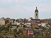 "Jardins suspendus" van Thuin | |
| Organs of the chapel of the Soeurs de Notre-Dame (nl) (fr) |
Thuin | 50.338911°N 4.291429°E |
56078-CLT-0007-01 Info |
|||
| Organs of the church of Notre-Dame des Carmes (nl) (fr) |
Thuin | 50.338739°N 4.287856°E |
56078-CLT-0008-01 Info |
|||
| Castle Leers-et-Fosteau and the facades and roofs of the outbuildings and the ensemble of the building and surrounding areas (nl) (fr) |
Thuin | 50.304867°N 4.252007°E |
56078-CLT-0010-01 Info |
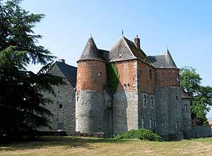 kasteel van Leers-et-Fosteau en de gevels en daken van de bijgebouwen en het ensemble van het gebouw en de omliggende terreinen | ||
| Woodland Church of Gozée (nl) (fr) |
Thuin | 50.352106°N 4.370620°E |
56078-CLT-0012-01 Info |
|||
| Various woods, meadows and a pond near the abbey farm Aulne (nl) (fr) |
Thuin | 50.362354°N 4.332106°E |
56078-CLT-0013-01 Info |
 Verschillende bossen, weilanden en een vijver in de buurt van de abdij-hoeve van Aulne | ||
| Land near the abbey farm Aulne (nl) (fr) |
Thuin | 50.360482°N 4.336369°E |
56078-CLT-0014-01 Info |
|||
| St. Martin's Church (nl) (fr) |
Thuin | Ragnies | 50.308314°N 4.284191°E |
56078-CLT-0015-01 Info |
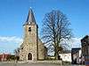 Kerk Saint-Martin | |
| Chapel of Ossogne and environment (nl) (fr) |
Thuin | 50.291162°N 4.342670°E |
56078-CLT-0016-01 Info |
|||
| Total parsonage Ragnies (nl) (fr) |
Thuin | 50.308679°N 4.283698°E |
56078-CLT-0017-01 Info |
|||
| Galleries at the foot of the belfry (nl) (fr) |
Thuin | place du Chapitre | 50.339728°N 4.286694°E |
56078-CLT-0018-01 Info |
.jpg) Galerijen aan de voet van het belfort | |
| Church of Notre-Dame d'el Vaux, retaining wall, sidewalk along the southern facade of the church, cobbled alleyways, stairway under the arch of the choir and the ensemble formed by the building, sidewalks, alleys and square du Moustier (old cemetery) (nl) (fr) |
Thuin | 50.341148°N 4.281764°E |
56078-CLT-0019-01 Info |
|||
| Ensemble formed by the buildings on Grand-Rue n ° s 36 and 38, and the park "Refuge d'Aulne" (now park of the town hall) (nl) (fr) |
Thuin | Grand-Rue n°s 36 et 38 | 50.339509°N 4.288421°E |
56078-CLT-0020-01 Info |
||
| Mill Biesmelle (nl) (fr) |
Thuin | rue des Compères | 50.297606°N 4.331766°E |
56078-CLT-0021-01 Info |
||
| House facades and roofs, except under a glass roof of the beginning of the century) and the house adjacent to the courtyard on the west (nl) (fr) |
Thuin | place Albert Ier n°13 | 50.339407°N 4.286435°E |
56078-CLT-0022-01 Info |
||
| Menhir called "Le Zeupire", near Route de Beaumont. Setting conservation. (nl) (fr) |
Thuin | Gozée | 50.329192°N 4.348334°E |
56078-CLT-0023-01 Info |
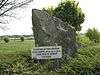 Menhir genaamd "Le Zeupire", nabij route de Beaumont. Instelling beschermingszone. | |
| The two remaining arches of the bridge over the Moines river called the Sambre downstream of the old abbey of Aulne, and on the right bank of this stream, rue de Leernes 13 (with the exception of the house built on the platform that can be accessed via the bridge and the masonry around the arches) (nl) (fr) |
Thuin | rue de Leernes 13 | 50.366595°N 4.336379°E |
56078-CLT-0024-01 Info |
||
| Forest of Grand Bon Dieu (nl) (fr) |
Thuin | 50.331714°N 4.286486°E |
56078-CLT-0025-01 Info |
|||
| Certain parts of the Aulne Abbey, with the abbey farm and the ensemble of the abbey and surrounding areas (nl) (fr) |
Thuin | 50.365738°N 4.331394°E |
56078-CLT-0026-01 Info |
.JPG) Bepaalde delen van de abdij van Aulne, met de abdij-hoeve en het ensemble van de abdij en de omliggende terreinen | ||
| Farmhouse Grande Couture and its environment (nl) (fr) |
Thuin | 50.295825°N 4.325184°E |
56078-CLT-0028-01 Info |
|||
| Zone around the forest "Bois du Prince" (nl) (fr) |
Thuin | 50.366646°N 4.340587°E |
56078-CLT-0029-01 Info |
|||
| Thuin Belfry (nl) (fr) |
Thuin | 50.339645°N 4.286605°E |
56078-PEX-0001-01 Info |
Belfort van Thuin | ||
| "Jardins suspendus" of Thuin (nl) (fr) |
Thuin | Thuin | 50.338295°N 4.290162°E |
56078-PEX-0002-01 Info |
 "Jardins suspendus" van Thuin | |
| Site of the Aulne Abbey and surrounding areas including the farm (nl) (fr) |
Thuin | 50.364186°N 4.332111°E |
56078-PEX-0003-01 Info |
Site van de abdij van Aulne en de omliggende terreinen met inbegrip van de hoeve |
See also
- List of protected heritage sites in Hainaut (province)
- Thuin
| Wikimedia Commons has media related to Cultural heritage monuments in Thuin. |
References
- Belgian heritage register: Direction générale opérationnelle - Aménagement du territoire, Logement, Patrimoine et Energie (DG4)
- www.dglive.be
This article is issued from Wikipedia. The text is licensed under Creative Commons - Attribution - Sharealike. Additional terms may apply for the media files.